Karte / Plan
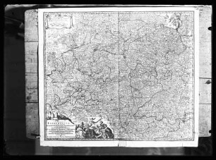
Westfälischer Kreis Territorialkarte Circulus Westphalicus 1.H. 18.Jh. 10 dt. Meilen = 7 cm 48 x 56 farb. Kupferstich: Matthäus Seutter, Augsburg B I Nr. 15
- Former reference number
-
B I 15
- Further information
-
Ort: Westfälischer Kreis
- Context
-
Karten A (Allgemein) >> 1. Topographische Karte, Übersichtskarten >> 1.3. Territorialkarten
- Holding
-
W 051 Karten A (Allgemein)
- Indexentry place
-
Westfälischer Kreis
Westfälischer Kreis, Territorialkarte, 1725
- Date of creation
-
1725
- Other object pages
- Provenance
-
Sammlungsregistraturbildner
- Delivered via
- Last update
-
05.11.2025, 4:01 PM CET
Data provider
This object is provided by:
Landesarchiv Nordrhein-Westfalen. Abteilung Westfalen. If you have any questions about the object, please contact the data provider.
Landesarchiv Nordrhein-Westfalen. Abteilung Westfalen. If you have any questions about the object, please contact the data provider.
Object type
- Karten / Pläne
Time of origin
- 1725
Other Objects (12)

Niedersächsischer Kreis Territorialkarte Saxoniae inferioris circulus 1.H. 18.Jh. 12 dt. Meilen = 10,3 cm 48 x 56 farb. Kupferstich: Matthäus Seutter, Augsburg B I Nr. 15

Nassau (Fürstentum) Territorialkarte Nassoviae principatus 1.H. 18.Jh. o.M. 47,5 x 56 farb. Kupferstich: Matthäus Seutter, Augsburg B I Nr. 15
Reproduktion: Circulus Franconicus von Matthäus Seutter, 18. Jh.

Westfalen (Herzogtum) Territorialkarte Ducatus Westphalia nova mappa geographica 1.H. 18.Jh. 3 dt. Meilen = 9,8 cm 47,5 x 55 kol. Stich: Matthäus Seutter, Augsburg B Nr. 358

Hildesheim (Fürstbistum) Territorialkarte Episcopatus Hildesiensis ... mappa georgraphica 1.H. 18.Jh. 4 dt. Meilen = 10,2 cm 46,5 x 54,5 farb. Kupferstich: Matthäus Seutter, Augsburg B I Nr. 15

Meißen (Markgrafschaft) Territorialkarte Marchionatus Misniae primaria elector. Saxoniae provincia 1.H. 18.Jh. 5 dt. Meilen = 8,7 cm 48 x 57 farb. Kupferstich: Matthäus, Seutter, Augsburg B I Nr. 15

Brandenburg (Kurfürstentum) Territorialkarte Electoratus sive Marchia Brandenburgensis .. in mappa geographica ... opera 1.H. 18.Jh. 6 dt. Meilen = 8,2cm 48 x 54 farb. Kupferstich Matthäus Seutter, Augsburg B I Nr. 15

Kirchenstaat Etrurien Territorialkarte Novissima et accuratissima delineatio status ecclesiae et magni ducatus Hetruriae 1.H. 18.Jh. 7 dt. Meilen = 6 cm 47 x 56 farb. Kupferstich: Matthäus Seutter, Augsburg B I 15

Hessen (Landgrafschaft) Territorialkarte Superior et inferior Hassiae landgraviatus ... 1.H. 18.Jh. 7 dt. Meilen = 9,7 cm 47 x 54,5 farb. Kupferstich: Matthäus Seutter, Augsburg Tobias Lotter sculp. B I Nr. 15

Bayern (Kreis und Kurfürstentum) Territorialkarte Bavariae circulus et electoratus in suas quaque ditiones 1.H. 18.Jh. 7 dt. Meilen = 8,2 cm 54 x 46 farb. Kupferstich: Johann Baptist Homann, Nürnberg B I Nr. 15

Schwäbischer Kreis Württemberg (Herzogtum) Übersichtskarte Circulus Suevicus in quo ducatus Wirtenbergensis ... curate designatus 1.H. 18.Jh. 7 dt. Meilen = 8,1 cm 48 x 55,5 farb. Kupferstich: Matthäus Seutter, Augsburg B I Nr. 15

Paderborn (Bistum) Territorialkarte Recens et accurata designatio episcopatus Paderbornensis ... exacte distincti 1.H. 18.Jh. 3 dt. Meilen = 9,6 cm 47,5 x 53 kol. Stich: Tobias Konrad Lotter Matthaeus Seutter, Augsburg B Nr. 360b
Niedersächsischer Kreis Territorialkarte Saxoniae inferioris circulus 1.H. 18.Jh. 12 dt. Meilen = 10,3 cm 48 x 56 farb. Kupferstich: Matthäus Seutter, Augsburg B I Nr. 15
Nassau (Fürstentum) Territorialkarte Nassoviae principatus 1.H. 18.Jh. o.M. 47,5 x 56 farb. Kupferstich: Matthäus Seutter, Augsburg B I Nr. 15
Reproduktion: Circulus Franconicus von Matthäus Seutter, 18. Jh.
Westfalen (Herzogtum) Territorialkarte Ducatus Westphalia nova mappa geographica 1.H. 18.Jh. 3 dt. Meilen = 9,8 cm 47,5 x 55 kol. Stich: Matthäus Seutter, Augsburg B Nr. 358
Hildesheim (Fürstbistum) Territorialkarte Episcopatus Hildesiensis ... mappa georgraphica 1.H. 18.Jh. 4 dt. Meilen = 10,2 cm 46,5 x 54,5 farb. Kupferstich: Matthäus Seutter, Augsburg B I Nr. 15
Meißen (Markgrafschaft) Territorialkarte Marchionatus Misniae primaria elector. Saxoniae provincia 1.H. 18.Jh. 5 dt. Meilen = 8,7 cm 48 x 57 farb. Kupferstich: Matthäus, Seutter, Augsburg B I Nr. 15
Brandenburg (Kurfürstentum) Territorialkarte Electoratus sive Marchia Brandenburgensis .. in mappa geographica ... opera 1.H. 18.Jh. 6 dt. Meilen = 8,2cm 48 x 54 farb. Kupferstich Matthäus Seutter, Augsburg B I Nr. 15
Kirchenstaat Etrurien Territorialkarte Novissima et accuratissima delineatio status ecclesiae et magni ducatus Hetruriae 1.H. 18.Jh. 7 dt. Meilen = 6 cm 47 x 56 farb. Kupferstich: Matthäus Seutter, Augsburg B I 15
Hessen (Landgrafschaft) Territorialkarte Superior et inferior Hassiae landgraviatus ... 1.H. 18.Jh. 7 dt. Meilen = 9,7 cm 47 x 54,5 farb. Kupferstich: Matthäus Seutter, Augsburg Tobias Lotter sculp. B I Nr. 15
Bayern (Kreis und Kurfürstentum) Territorialkarte Bavariae circulus et electoratus in suas quaque ditiones 1.H. 18.Jh. 7 dt. Meilen = 8,2 cm 54 x 46 farb. Kupferstich: Johann Baptist Homann, Nürnberg B I Nr. 15
Schwäbischer Kreis Württemberg (Herzogtum) Übersichtskarte Circulus Suevicus in quo ducatus Wirtenbergensis ... curate designatus 1.H. 18.Jh. 7 dt. Meilen = 8,1 cm 48 x 55,5 farb. Kupferstich: Matthäus Seutter, Augsburg B I Nr. 15