Karte / Plan
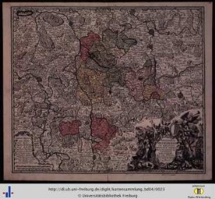
Hildesheim (Fürstbistum) Territorialkarte Episcopatus Hildesiensis ... mappa georgraphica 1.H. 18.Jh. 4 dt. Meilen = 10,2 cm 46,5 x 54,5 farb. Kupferstich: Matthäus Seutter, Augsburg B I Nr. 15
- Former reference number
-
B I 15
- Further information
-
Ort: Fürstbistum Hildesheim
- Context
-
Karten A (Allgemein) >> 1. Topographische Karte, Übersichtskarten >> 1.3. Territorialkarten
- Holding
-
W 051 Karten A (Allgemein)
- Indexentry place
-
Fürstbistum Hildesheim
Hildesheim, Bistum, Territorialkarte, 1725
- Date of creation
-
1725
- Other object pages
- Provenance
-
Sammlungsregistraturbildner
- Delivered via
- Last update
-
17.09.2025, 3:08 PM CEST
Data provider
This object is provided by:
Landesarchiv Nordrhein-Westfalen. Abteilung Westfalen. If you have any questions about the object, please contact the data provider.
Landesarchiv Nordrhein-Westfalen. Abteilung Westfalen. If you have any questions about the object, please contact the data provider.
Object type
- Karten / Pläne
Time of origin
- 1725
Other Objects (12)

Westfalen (Herzogtum) Territorialkarte Ducatus Westphalia nova mappa geographica 1.H. 18.Jh. 3 dt. Meilen = 9,8 cm 47,5 x 55 kol. Stich: Matthäus Seutter, Augsburg B Nr. 358

Episcopatus Hildesiensis Cum Adiacentibus Provinciis Ac Statibus Mappa Geographica Repraesentatus

Brandenburg (Kurfürstentum) Territorialkarte Electoratus sive Marchia Brandenburgensis .. in mappa geographica ... opera 1.H. 18.Jh. 6 dt. Meilen = 8,2cm 48 x 54 farb. Kupferstich Matthäus Seutter, Augsburg B I Nr. 15

Nassau (Fürstentum) Territorialkarte Nassoviae principatus 1.H. 18.Jh. o.M. 47,5 x 56 farb. Kupferstich: Matthäus Seutter, Augsburg B I Nr. 15

Westfälischer Kreis Territorialkarte Circulus Westphalicus 1.H. 18.Jh. 10 dt. Meilen = 7 cm 48 x 56 farb. Kupferstich: Matthäus Seutter, Augsburg B I Nr. 15

Paderborn (Bistum) Territorialkarte 18.Jh. 3 dt. Meilen = 9,5 cm 47,5 x 53 farb. Stich: Matthaeus Seutter, Augsburg Tob. Con. Lotter sc. Bem.: Stadtansicht
Episcopatus Hildesiensis
Episcopus Hildesiensis.
Episcopatus Hildesiensis

Niedersächsischer Kreis Territorialkarte Saxoniae inferioris circulus 1.H. 18.Jh. 12 dt. Meilen = 10,3 cm 48 x 56 farb. Kupferstich: Matthäus Seutter, Augsburg B I Nr. 15
Organographia Hildesiensis specialis

Kleve (Herzogtum) Mark (Grafschaft) Territorialkarte Nova et accurata Cliviae et comitatus Marchiae 18.Jh. 3 dt. Meilen = 6,7 cm 47,5 x 56 farb. Stich: Matthaeus Seutter, Augsburg
Westfalen (Herzogtum) Territorialkarte Ducatus Westphalia nova mappa geographica 1.H. 18.Jh. 3 dt. Meilen = 9,8 cm 47,5 x 55 kol. Stich: Matthäus Seutter, Augsburg B Nr. 358
Episcopatus Hildesiensis Cum Adiacentibus Provinciis Ac Statibus Mappa Geographica Repraesentatus
Brandenburg (Kurfürstentum) Territorialkarte Electoratus sive Marchia Brandenburgensis .. in mappa geographica ... opera 1.H. 18.Jh. 6 dt. Meilen = 8,2cm 48 x 54 farb. Kupferstich Matthäus Seutter, Augsburg B I Nr. 15
Nassau (Fürstentum) Territorialkarte Nassoviae principatus 1.H. 18.Jh. o.M. 47,5 x 56 farb. Kupferstich: Matthäus Seutter, Augsburg B I Nr. 15
Westfälischer Kreis Territorialkarte Circulus Westphalicus 1.H. 18.Jh. 10 dt. Meilen = 7 cm 48 x 56 farb. Kupferstich: Matthäus Seutter, Augsburg B I Nr. 15
Paderborn (Bistum) Territorialkarte 18.Jh. 3 dt. Meilen = 9,5 cm 47,5 x 53 farb. Stich: Matthaeus Seutter, Augsburg Tob. Con. Lotter sc. Bem.: Stadtansicht
Episcopatus Hildesiensis
Episcopus Hildesiensis.
Episcopatus Hildesiensis
Niedersächsischer Kreis Territorialkarte Saxoniae inferioris circulus 1.H. 18.Jh. 12 dt. Meilen = 10,3 cm 48 x 56 farb. Kupferstich: Matthäus Seutter, Augsburg B I Nr. 15
Organographia Hildesiensis specialis