Karte / Plan
Nassau (Fürstentum) Territorialkarte Nassoviae principatus 1.H. 18.Jh. o.M. 47,5 x 56 farb. Kupferstich: Matthäus Seutter, Augsburg B I Nr. 15
- Alt-/Vorsignatur
-
B I,15
- Sonstige Erschließungsangaben
-
Ort: Fürstentum Nassau
- Kontext
-
Karten A (Allgemein) >> 1. Topographische Karte, Übersichtskarten >> 1.3. Territorialkarten
- Bestand
-
W 051 Karten A (Allgemein)
- Indexbegriff Ort
-
Fürstentum Nassau
Nassau, Fürstentum, Territorialkarte, 1725
- Laufzeit
-
1725
- Weitere Objektseiten
- Provenienz
-
Sammlungsregistraturbildner
- Geliefert über
- Letzte Aktualisierung
-
17.09.2025, 14:46 MESZ
Datenpartner
Dieses Objekt wird bereitgestellt von:
Landesarchiv Nordrhein-Westfalen. Abteilung Westfalen. Bei Fragen zum Objekt wenden Sie sich bitte an den Datenpartner.
Landesarchiv Nordrhein-Westfalen. Abteilung Westfalen. Bei Fragen zum Objekt wenden Sie sich bitte an den Datenpartner.
Objekttyp
- Karten / Pläne
Entstanden
- 1725
Ähnliche Objekte (12)
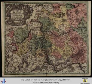
Nassoviae principatus

Westfälischer Kreis Territorialkarte Circulus Westphalicus 1.H. 18.Jh. 10 dt. Meilen = 7 cm 48 x 56 farb. Kupferstich: Matthäus Seutter, Augsburg B I Nr. 15

Principatus Nassoviae : die Erhebung der Grafen von Nassau in den Fürstenstand des Heiligen Römischen Reiches

Paderborn (Bistum) Territorialkarte 18.Jh. 3 dt. Meilen = 9,5 cm 47,5 x 53 farb. Stich: Matthaeus Seutter, Augsburg Tob. Con. Lotter sc. Bem.: Stadtansicht

Niedersächsischer Kreis Territorialkarte Saxoniae inferioris circulus 1.H. 18.Jh. 12 dt. Meilen = 10,3 cm 48 x 56 farb. Kupferstich: Matthäus Seutter, Augsburg B I Nr. 15
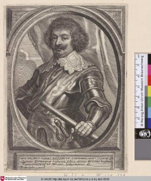
Wilhelmus Comes Nassoviae

Kleve (Herzogtum) Mark (Grafschaft) Territorialkarte Nova et accurata Cliviae et comitatus Marchiae 18.Jh. 3 dt. Meilen = 6,7 cm 47,5 x 56 farb. Stich: Matthaeus Seutter, Augsburg

Westfalen (Herzogtum) Territorialkarte Ducatus Westphalia nova mappa geographica 1.H. 18.Jh. 3 dt. Meilen = 9,8 cm 47,5 x 55 kol. Stich: Matthäus Seutter, Augsburg B Nr. 358
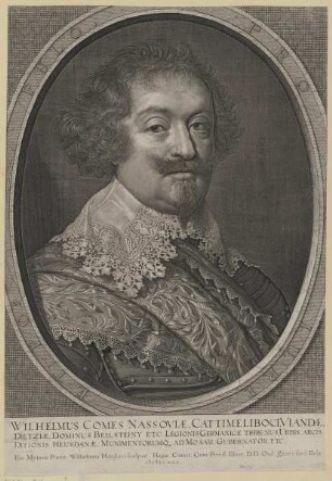
Bildnis des Wilhelmus Nassoviae
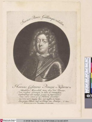
Henricus Casimirus Princeps Nassoviae

Meißen (Markgrafschaft) Territorialkarte Marchionatus Misniae primaria elector. Saxoniae provincia 1.H. 18.Jh. 5 dt. Meilen = 8,7 cm 48 x 57 farb. Kupferstich: Matthäus, Seutter, Augsburg B I Nr. 15

Hildesheim (Fürstbistum) Territorialkarte Episcopatus Hildesiensis ... mappa georgraphica 1.H. 18.Jh. 4 dt. Meilen = 10,2 cm 46,5 x 54,5 farb. Kupferstich: Matthäus Seutter, Augsburg B I Nr. 15
Nassoviae principatus
Westfälischer Kreis Territorialkarte Circulus Westphalicus 1.H. 18.Jh. 10 dt. Meilen = 7 cm 48 x 56 farb. Kupferstich: Matthäus Seutter, Augsburg B I Nr. 15
Principatus Nassoviae : die Erhebung der Grafen von Nassau in den Fürstenstand des Heiligen Römischen Reiches
Paderborn (Bistum) Territorialkarte 18.Jh. 3 dt. Meilen = 9,5 cm 47,5 x 53 farb. Stich: Matthaeus Seutter, Augsburg Tob. Con. Lotter sc. Bem.: Stadtansicht
Niedersächsischer Kreis Territorialkarte Saxoniae inferioris circulus 1.H. 18.Jh. 12 dt. Meilen = 10,3 cm 48 x 56 farb. Kupferstich: Matthäus Seutter, Augsburg B I Nr. 15
Wilhelmus Comes Nassoviae
Kleve (Herzogtum) Mark (Grafschaft) Territorialkarte Nova et accurata Cliviae et comitatus Marchiae 18.Jh. 3 dt. Meilen = 6,7 cm 47,5 x 56 farb. Stich: Matthaeus Seutter, Augsburg
Westfalen (Herzogtum) Territorialkarte Ducatus Westphalia nova mappa geographica 1.H. 18.Jh. 3 dt. Meilen = 9,8 cm 47,5 x 55 kol. Stich: Matthäus Seutter, Augsburg B Nr. 358
Bildnis des Wilhelmus Nassoviae
Henricus Casimirus Princeps Nassoviae
Meißen (Markgrafschaft) Territorialkarte Marchionatus Misniae primaria elector. Saxoniae provincia 1.H. 18.Jh. 5 dt. Meilen = 8,7 cm 48 x 57 farb. Kupferstich: Matthäus, Seutter, Augsburg B I Nr. 15