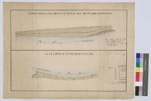
Karten und Pläne
Umgebung von Hafenlohr, Rothenfels und Neustadt a.M.
Enthält: Gemarkungsplan
- Reference number
-
Landesarchiv Baden-Württemberg, Abt. Staatsarchiv Wertheim, R-K Nr. 6755
- Dimensions
-
33 x 41 (Höhe x Breite)
- Notes
-
aus StAWt-R Lit. B 6827 b
- Further information
-
Ausführung: Federzeichnung; handkoloriert
- Context
-
Karten und Pläne >> C. Bayern >> C.13. Hafenlohr >> C.13.5. Hafenlohr
- Holding
-
Landesarchiv Baden-Württemberg, Abt. Staatsarchiv Wertheim, R-K Karten und Pläne
- Creator
-
Autor/Fotograf: H. Müller
- Date of creation
-
[1897]
- Other object pages
- Rights
-
Es gelten die Nutzungsbedingungen des Landesarchivs Baden-Württemberg.
- Last update
-
26.03.2024, 9:03 AM CET
Data provider
This object is provided by:
Landesarchiv Baden-Württemberg. If you have any questions about the object, please contact the data provider.
Landesarchiv Baden-Württemberg. If you have any questions about the object, please contact the data provider.
Object type
- Karten und Pläne
Associated
- Autor/Fotograf: H. Müller
Time of origin
- [1897]
Other Objects (12)

Steuergemeinde Hafenlohr, Herrschaftsgericht Rothenfels
Volksschulwesen: Hafenlohr bei Rothenfels. Schule.
Hofgut Hafenlohr
Gemarkung Hafenlohr
Hafenlohr: Lauterhof
Hofgut Hafenlohr
Hofgut Hafenlohr
Hofwiese ober Hafenlohr und Langewiese unter Hafenlohr (Inselkarte)
Hafenlohr: Lauterhof (Inselkarte)
![[Lauterhof bei Hafenlohr]](https://iiif.deutsche-digitale-bibliothek.de/image/2/141e03f0-7a8d-42cc-be3b-ebe478583497/full/!306,450/0/default.jpg)
[Lauterhof bei Hafenlohr]
![[Lauterhof bei Hafenlohr]](https://iiif.deutsche-digitale-bibliothek.de/image/2/2e73b005-2da3-4919-a1d3-86c91124242d/full/!306,450/0/default.jpg)
[Lauterhof bei Hafenlohr]
Sägewerk Hubertus [Hafenlohr]
Steuergemeinde Hafenlohr, Herrschaftsgericht Rothenfels
Volksschulwesen: Hafenlohr bei Rothenfels. Schule.
Hofgut Hafenlohr
Gemarkung Hafenlohr
Hafenlohr: Lauterhof
Hofgut Hafenlohr
Hofgut Hafenlohr
Hofwiese ober Hafenlohr und Langewiese unter Hafenlohr (Inselkarte)
Hafenlohr: Lauterhof (Inselkarte)
[Lauterhof bei Hafenlohr]
[Lauterhof bei Hafenlohr]