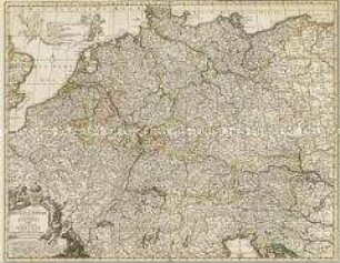
- Standort
-
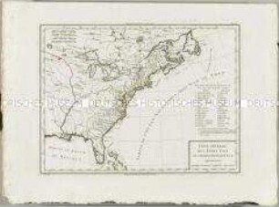
Deutsches Historisches Museum, Berlin
- Inventarnummer
-
1988/1789
- Maße
-
Höhe x Breite: 52,4 x 60,9 cm (Blatt), Höhe x Breite: 59,4 x 57,3 cm (Platte), Höhe x Breite: 47,3 x 54,6 cm (Karte)
- Material/Technik
-
Papier, Kupferstich, Flächen- und Grenzkolorit
- Klassifikation
-
Kartografie (Gattung)
- Bezug (was)
-
Kreisverfassung
Lüneburg
Holstein
Mecklenburg
Magdeburg
Braunschweig
Bremen
- Ereignis
-
Herstellung
- (wer)
-
Geograph, Kartograf, Verleger: Matthäus Seutter (1678)
- (wann)
-
um 1730
- Rechteinformation
-
Deutsches Historisches Museum
- Letzte Aktualisierung
-
24.03.2023, 09:29 MEZ
Datenpartner
Dieses Objekt wird bereitgestellt von:
Stiftung Deutsches Historisches Museum. Bei Fragen zum Objekt wenden Sie sich bitte an den Datenpartner.
Stiftung Deutsches Historisches Museum. Bei Fragen zum Objekt wenden Sie sich bitte an den Datenpartner.
Objekttyp
- Grenzkarte
Beteiligte
- Geograph, Kartograf, Verleger: Matthäus Seutter (1678)
Entstanden
- um 1730
Ähnliche Objekte (12)
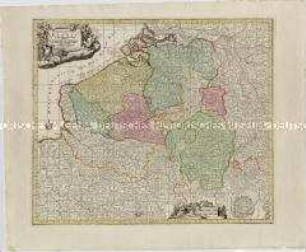
Germaniae Inferioris sive Belgii. Mit einem Fortifikationsplan: Ostende

Kurrheinischer Reichskreis: S. R. I. Circulus Rhenanus Inferior Sive Electorum Rheni complectens tres Archiepiscopatus, Moguntinum, Coloniensem et Trevirensem, Palatinatum Rheni, Comit. Beilstein, Newenaer, Inf. Isenburg, et Reiferscheit repraesentatus â Ioh. Baptista Homanno Norimbergae
Karte: Beschreibung der Schweiz; 1751

Deutschland vom Major C. F. Hammer. Nürnberg bey Friedrich Campe

Tableau Général de l'Asie
Partie Septentrionale de la Couronne de Castille
Cataloniae Principatus et Ruscinonis ac Cerretaniae Comitatuum

Prächtig gestaltete Titelkartusche mit Darstellung der vor Spaniens Küste operierenden englischen Flotte mit Einschiffungsszenerie und der Ankunft von Karl III. in Spanien.
Peraccurata S. Romani Imperii Tabula comprehendens Regiones vulgo Sub Nomine Germaniae Nuncupantes
BORUSSIAE - REGNUM

Atlas Nouveau: Carte du Golfe du Mexique et des Isles Antilles
Atlas Nouveau: Carte Générale des Etats Unis de l'Amérique septentrionale
Germaniae Inferioris sive Belgii. Mit einem Fortifikationsplan: Ostende
Kurrheinischer Reichskreis: S. R. I. Circulus Rhenanus Inferior Sive Electorum Rheni complectens tres Archiepiscopatus, Moguntinum, Coloniensem et Trevirensem, Palatinatum Rheni, Comit. Beilstein, Newenaer, Inf. Isenburg, et Reiferscheit repraesentatus â Ioh. Baptista Homanno Norimbergae
Karte: Beschreibung der Schweiz; 1751
Deutschland vom Major C. F. Hammer. Nürnberg bey Friedrich Campe
Tableau Général de l'Asie
Partie Septentrionale de la Couronne de Castille
Cataloniae Principatus et Ruscinonis ac Cerretaniae Comitatuum
Prächtig gestaltete Titelkartusche mit Darstellung der vor Spaniens Küste operierenden englischen Flotte mit Einschiffungsszenerie und der Ankunft von Karl III. in Spanien.
Peraccurata S. Romani Imperii Tabula comprehendens Regiones vulgo Sub Nomine Germaniae Nuncupantes
BORUSSIAE - REGNUM
Atlas Nouveau: Carte du Golfe du Mexique et des Isles Antilles