- Alternative title
-
TABLEAU GÉNÉRAL DE L'ASIE, / comprenant / LES PRINCIPAUX ETATS OU PAYS ET LES CORPS D'ISLES, QUI COMPOSENT CETTE GRANDE PARTIE DU MONDE, AU NOMBRE DE HUIT; / LEURS DIVISIONS PAR PROVINCES,
- Location
-
Deutsches Historisches Museum, Berlin
- Inventory number
-
Do 2006/244
- Measurements
-
Höhe x Breite: 58 x 80,6 cm (Blatt)
Höhe x Breite: 34,8 x 43,3 cm (Karte)
Höhe x Breite: 54,8 x 77 cm (Platte)
- Material/Technique
-
Druckfarbe, Papier, Kupferstich, grenzkoloriert
- Classification
-
Kartografie (Gattung)
- Subject (what)
-
Asien
- Event
-
Herstellung
- (who)
-
Geograph, Kartograf: Louis Brion de la Tour (1756)
Verlag: Campion frères
- (where)
-
Paris, Frankreich
- (when)
-
1787
- Rights
-
Deutsches Historisches Museum
- Last update
-
24.03.2023, 9:27 AM CET
Data provider
This object is provided by:
Stiftung Deutsches Historisches Museum. If you have any questions about the object, please contact the data provider.
Stiftung Deutsches Historisches Museum. If you have any questions about the object, please contact the data provider.
Object type
- Grenzkarte
Associated
- Geograph, Kartograf: Louis Brion de la Tour (1756)
- Verlag: Campion frères
Time of origin
- 1787
Other Objects (12)
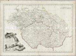
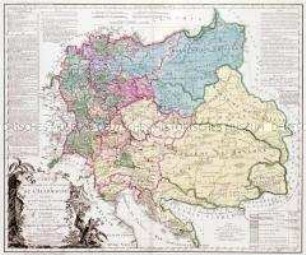
Carte des Etats de Boheme en général
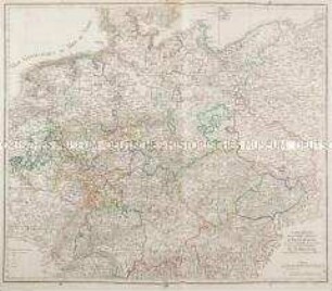
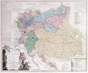
Carte réduite de la Carte Génerale d'Allemagne
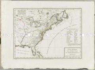
Atlas Nouveau: Carte Générale des Etats Unis de l'Amérique septentrionale
Brion et Maire: Tableau Géographique Et Politique De L'Allemagne. Blatt 3: Carte Des Etats de la Confédération du Rhin. Conformément au traité de paix de Vienne, 14 Octobre 1809. Carte comprenant en entier l'Empire d' Autriche, la Confédération du Rhin, le Duché de Warsovie, au Roi de Saxe, le Royaume de Prusse; les Provinces Illyriennes et autre Etats à l'Empereur des Francais. Roi d'Italie. Par Brion et Maire, Ing. Géog. 1809. avec des changemens on 1811.
Brion et Maire: Tableau Géographique Et Politique De L'Allemagne. Blatt 1: Carte Élementaire Et Statistique De L'Allemagne, Conformément au traité de paix de Lunéville, de l'an 9 - 1801; et au recès de la diète de l'Empire, à Ratisbonne, de l'an 11 - 1803. Carte comprenant, de plus, Les Etats Autrichiens et Prussiens, hors de l'Allemagne. Par Brion et Maire, Ingénieurs-Géographes. Nouvelle édition augmentée, surtout des positions les plus signalées par la marche victorieuse et inonie des armées françaises en 1805.

Europa: Carte Générale De Toute L'Europe, Divisée Selon L'Etendue De Ses Principaux Etats, Subdivisée En Leurs Principales Provinces. Einzelkarten (6) auf der Rückseite betitelt: General-Charte von Europa nebst einigen Laendern von angrenzenden Welttheilen, Schuber fehlt
Brion et Maire: Tableau Géographique Et Politique De L'Allemagne. Blatt 2: Carte Élementaire Et Statistique De L'Allemagne, Conformément au traité de paix de Lunéville, de l'an 9 - 1801; et au recès de la diète de l'Empire, à Ratisbonne, de l'an 11 - 1803. Carte Comprenant, En Entier, La Confédération Du Rhin, Les Etats Autrichens Et Prussiens suivant le traité de Presbourg en 1805 et ceux de Tilsitt en 1807. Par BRION et MAIRE, Ingenieurs-Géographes. Nouvelle édition augmentée, surtout des positions les plus signalées par la marche victorieuse et inoure des armées françaises, et par des conventions ou traités. 1809.

Carte Géographi-Diplomatique Suivant les Derniers Traités De Paix. Dédiée Au Général Beurnonville Ambassadeur De La République Francaise. Nebenkarte: Carte De La République Ionienne
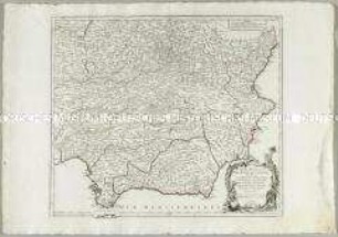
Partie Meridionale des Etats de Castille
Germaniae Inferioris sive Belgii. Mit einem Fortifikationsplan: Ostende
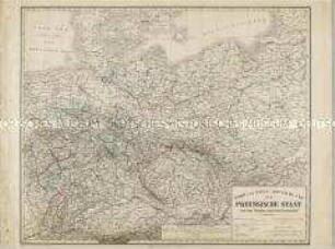
Nord und West-Deutschland der Preussische Staat und die übrigen Zollvereinsstaaten
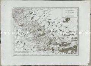
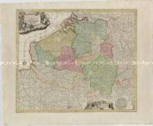
Atlas Nouveau: Gouvernement de Flandre
Carte des Etats de Boheme en général
Carte réduite de la Carte Génerale d'Allemagne
Atlas Nouveau: Carte Générale des Etats Unis de l'Amérique septentrionale
Brion et Maire: Tableau Géographique Et Politique De L'Allemagne. Blatt 3: Carte Des Etats de la Confédération du Rhin. Conformément au traité de paix de Vienne, 14 Octobre 1809. Carte comprenant en entier l'Empire d' Autriche, la Confédération du Rhin, le Duché de Warsovie, au Roi de Saxe, le Royaume de Prusse; les Provinces Illyriennes et autre Etats à l'Empereur des Francais. Roi d'Italie. Par Brion et Maire, Ing. Géog. 1809. avec des changemens on 1811.
Brion et Maire: Tableau Géographique Et Politique De L'Allemagne. Blatt 1: Carte Élementaire Et Statistique De L'Allemagne, Conformément au traité de paix de Lunéville, de l'an 9 - 1801; et au recès de la diète de l'Empire, à Ratisbonne, de l'an 11 - 1803. Carte comprenant, de plus, Les Etats Autrichiens et Prussiens, hors de l'Allemagne. Par Brion et Maire, Ingénieurs-Géographes. Nouvelle édition augmentée, surtout des positions les plus signalées par la marche victorieuse et inonie des armées françaises en 1805.
Europa: Carte Générale De Toute L'Europe, Divisée Selon L'Etendue De Ses Principaux Etats, Subdivisée En Leurs Principales Provinces. Einzelkarten (6) auf der Rückseite betitelt: General-Charte von Europa nebst einigen Laendern von angrenzenden Welttheilen, Schuber fehlt
Brion et Maire: Tableau Géographique Et Politique De L'Allemagne. Blatt 2: Carte Élementaire Et Statistique De L'Allemagne, Conformément au traité de paix de Lunéville, de l'an 9 - 1801; et au recès de la diète de l'Empire, à Ratisbonne, de l'an 11 - 1803. Carte Comprenant, En Entier, La Confédération Du Rhin, Les Etats Autrichens Et Prussiens suivant le traité de Presbourg en 1805 et ceux de Tilsitt en 1807. Par BRION et MAIRE, Ingenieurs-Géographes. Nouvelle édition augmentée, surtout des positions les plus signalées par la marche victorieuse et inoure des armées françaises, et par des conventions ou traités. 1809.
Carte Géographi-Diplomatique Suivant les Derniers Traités De Paix. Dédiée Au Général Beurnonville Ambassadeur De La République Francaise. Nebenkarte: Carte De La République Ionienne
Partie Meridionale des Etats de Castille
Germaniae Inferioris sive Belgii. Mit einem Fortifikationsplan: Ostende
Nord und West-Deutschland der Preussische Staat und die übrigen Zollvereinsstaaten