- Alternative title
-
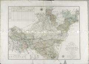
Karte / von / DEUTSCHLAND / in XVI. Blatt
- Location
-
Deutsches Historisches Museum, Berlin
- Inventory number
-
Do 61/336
- Measurements
-
Höhe x Breite: 101,3 x 118,8 cm (Blatt)
Höhe x Breite: 96,3 x 113,3 cm (Karte)
Höhe x Breite: 99 x 116,4 cm (Platte)
- Material/Technique
-
Druckfarbe, Papier : Leinwand, Kupferstich, koloriert, grenzkoloriert
- Classification
-
Kartografie (Gattung)
- Subject (what)
-
Deutschland
- Event
-
Herstellung
- (who)
-
Geograph, Kartograf, Stecher, Landvermesser: Daniel Friedrich Sotzmann
Kartograph?: Johann W. Meil
Stecher, Verleger: Carl Jäck
Verlag: Königlich Preußische Akademie Kunst- und Buchhandlung
- (where)
-
Berlin, Deutschland
- (when)
-
zwischen 1789 und 1792
- Rights
-
Deutsches Historisches Museum
- Last update
-
24.03.2023, 9:28 AM CET
Data provider
This object is provided by:
Stiftung Deutsches Historisches Museum. If you have any questions about the object, please contact the data provider.
Stiftung Deutsches Historisches Museum. If you have any questions about the object, please contact the data provider.
Object type
- Regionalkarte
Associated
- Geograph, Kartograf, Stecher, Landvermesser: Daniel Friedrich Sotzmann
- Kartograph?: Johann W. Meil
- Stecher, Verleger: Carl Jäck
- Verlag: Königlich Preußische Akademie Kunst- und Buchhandlung
Time of origin
- zwischen 1789 und 1792
Other Objects (12)
Special Charte von den Westphälschen Provinzen
Karte von Deutschland in XVI Blatt nach H. O. C. Büsching Erdbeschreibung u. den besten Hülfsmitteln entworffen von D. F. Sotzmann.
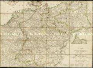
Neueste Post Karte von Deutschland und dessen angrenzenden Ländern.
!["Neuste Post-Karte von DEUTSCHLAND und dessen angrenzenden Länder"; Abschnitt Paris - Lemberg [Lvow], Appenrade [Abenrå] - Mantua. [Carl] Jäck (Stecher, Verfasser?). 1. Auflage; Stich. 1 : 2.200.000. Berlin. Mehrfach gefaltet, 79 x 56,5 cm; thematische Karte mit Einzeichnungen der Poststrecken und -stationen (Abstände von 1/4 bis 4 Meilen); Karte aus 16 Teilen zusammengesetzt und auf Leinen aufgezogen; Post- oder Reisekarte [vgl. Nr. 373]. Bem.: ohne Maßstab; polständiges Meridiangitternetz; Einzeichnungen der Poststrecken mit verschiedenen Beförderungsmöglichkeiten und Abständen.](/assets/placeholder/searchResultMediaNoDigitisedMedia.png)
"Neuste Post-Karte von DEUTSCHLAND und dessen angrenzenden Länder"; Abschnitt Paris - Lemberg [Lvow], Appenrade [Abenrå] - Mantua. [Carl] Jäck (Stecher, Verfasser?). 1. Auflage; Stich. 1 : 2.200.000. Berlin. Mehrfach gefaltet, 79 x 56,5 cm; thematische Karte mit Einzeichnungen der Poststrecken und -stationen (Abstände von 1/4 bis 4 Meilen); Karte aus 16 Teilen zusammengesetzt und auf Leinen aufgezogen; Post- oder Reisekarte [vgl. Nr. 373]. Bem.: ohne Maßstab; polständiges Meridiangitternetz; Einzeichnungen der Poststrecken mit verschiedenen Beförderungsmöglichkeiten und Abständen.

Karte von Dresden und Umgebung von Freiberg im Westen bis Neustadt im Osten und mit der Sächsischen Schweiz sowie einem Maßstab in Deutschen Meilen
![Karte und Übersicht der ganzen Operation am Ober-Rhein im Jahre 1793 : nebst allen Stellungen der königl. Preußis. auch kaiserl. königl. Truppen und Bataillen, unter Führung und Befehl Sr. K. Majestät v[on] Preußen; hernachmals aber unter Befehl Sr. Hochfürstl. Durchl. des regierenden Herzogs von Braunschweig und kaiserl. königl. General-Lieutenants Grafen von Wurmser / gestochen von Carl Jäck. - Berlin, [ca. 1798]](https://iiif.deutsche-digitale-bibliothek.de/image/2/0a8cdf00-401b-45d9-8c1d-63315fd27e38/full/!306,450/0/default.jpg)
Karte und Übersicht der ganzen Operation am Ober-Rhein im Jahre 1793 : nebst allen Stellungen der königl. Preußis. auch kaiserl. königl. Truppen und Bataillen, unter Führung und Befehl Sr. K. Majestät v[on] Preußen; hernachmals aber unter Befehl Sr. Hochfürstl. Durchl. des regierenden Herzogs von Braunschweig und kaiserl. königl. General-Lieutenants Grafen von Wurmser / gestochen von Carl Jäck. - Berlin, [ca. 1798]
![112: Głogów, Polen, (dt. Glogau), 1820 : 112 : [Glogau]. - [1:200 000]. - Berlin : Stark , [ca. 1820]. - 1 Kt. : Stich // Maßstabsangabe in graph. Form (geogr. Meile)](https://iiif.deutsche-digitale-bibliothek.de/image/2/638e6c62-c807-4134-b55d-772a78eb94e1/full/!306,450/0/default.jpg)
112: Głogów, Polen, (dt. Glogau), 1820 : 112 : [Glogau]. - [1:200 000]. - Berlin : Stark , [ca. 1820]. - 1 Kt. : Stich // Maßstabsangabe in graph. Form (geogr. Meile)
Treffen bey Hohkirch
![Neueste Postcharte von Teutschland und dessen angränzenden Ländern / gestochen von Jäck. - Berlin : Simon Schropp, [ca. 1799]](https://iiif.deutsche-digitale-bibliothek.de/image/2/8ea5dd47-d0e4-4fb1-9d99-93abe4750156/full/!306,450/0/default.jpg)
Neueste Postcharte von Teutschland und dessen angränzenden Ländern / gestochen von Jäck. - Berlin : Simon Schropp, [ca. 1799]
![Charte von Ostpreussen nebst Preussisch-Litthauen und Westpreussen nebst dem Netzdistrict etc. / [gestochen von C. Jäck]. - [Ca. 1:150.000]. - Berlin, 1804. - [1 Kt. Kupferst.. ; 55 x 40 cm]](https://iiif.deutsche-digitale-bibliothek.de/image/2/3eecfea1-b376-4f2f-99b8-97e8a7100545/full/!306,450/0/default.jpg)
Charte von Ostpreussen nebst Preussisch-Litthauen und Westpreussen nebst dem Netzdistrict etc. / [gestochen von C. Jäck]. - [Ca. 1:150.000]. - Berlin, 1804. - [1 Kt. Kupferst.. ; 55 x 40 cm]

Berlin, b. Lagarde: Vorzeichnungen in Buchstaben und Zügen für Schriftstecher, Mahler, Graveurs, Petschierstecher, Steinmetzer, Schriftschneider, Glasschleifer, Juwelier, u. für jeden, der regelmässige und zierliche Buchstaben zu stechen, zu mahlen oder in und aus Metall zu formen hat. Von Carl Jäck. 1. Heft. 14 Blätter. 2. Heft 12 Blätter.

Anticritik gegen die Recension der neuesten Postcharte von Teutschland, gestochen von Jäck in Berlin. In Commission bey Simon Schropp et. Comp. In den A. G. E. May 1800. 458 bis 475
Special Charte von den Westphälschen Provinzen
Karte von Deutschland in XVI Blatt nach H. O. C. Büsching Erdbeschreibung u. den besten Hülfsmitteln entworffen von D. F. Sotzmann.
Neueste Post Karte von Deutschland und dessen angrenzenden Ländern.
"Neuste Post-Karte von DEUTSCHLAND und dessen angrenzenden Länder"; Abschnitt Paris - Lemberg [Lvow], Appenrade [Abenrå] - Mantua. [Carl] Jäck (Stecher, Verfasser?). 1. Auflage; Stich. 1 : 2.200.000. Berlin. Mehrfach gefaltet, 79 x 56,5 cm; thematische Karte mit Einzeichnungen der Poststrecken und -stationen (Abstände von 1/4 bis 4 Meilen); Karte aus 16 Teilen zusammengesetzt und auf Leinen aufgezogen; Post- oder Reisekarte [vgl. Nr. 373]. Bem.: ohne Maßstab; polständiges Meridiangitternetz; Einzeichnungen der Poststrecken mit verschiedenen Beförderungsmöglichkeiten und Abständen.
Karte von Dresden und Umgebung von Freiberg im Westen bis Neustadt im Osten und mit der Sächsischen Schweiz sowie einem Maßstab in Deutschen Meilen
Karte und Übersicht der ganzen Operation am Ober-Rhein im Jahre 1793 : nebst allen Stellungen der königl. Preußis. auch kaiserl. königl. Truppen und Bataillen, unter Führung und Befehl Sr. K. Majestät v[on] Preußen; hernachmals aber unter Befehl Sr. Hochfürstl. Durchl. des regierenden Herzogs von Braunschweig und kaiserl. königl. General-Lieutenants Grafen von Wurmser / gestochen von Carl Jäck. - Berlin, [ca. 1798]
112: Głogów, Polen, (dt. Glogau), 1820 : 112 : [Glogau]. - [1:200 000]. - Berlin : Stark , [ca. 1820]. - 1 Kt. : Stich // Maßstabsangabe in graph. Form (geogr. Meile)
Treffen bey Hohkirch
Neueste Postcharte von Teutschland und dessen angränzenden Ländern / gestochen von Jäck. - Berlin : Simon Schropp, [ca. 1799]
Charte von Ostpreussen nebst Preussisch-Litthauen und Westpreussen nebst dem Netzdistrict etc. / [gestochen von C. Jäck]. - [Ca. 1:150.000]. - Berlin, 1804. - [1 Kt. Kupferst.. ; 55 x 40 cm]
Berlin, b. Lagarde: Vorzeichnungen in Buchstaben und Zügen für Schriftstecher, Mahler, Graveurs, Petschierstecher, Steinmetzer, Schriftschneider, Glasschleifer, Juwelier, u. für jeden, der regelmässige und zierliche Buchstaben zu stechen, zu mahlen oder in und aus Metall zu formen hat. Von Carl Jäck. 1. Heft. 14 Blätter. 2. Heft 12 Blätter.