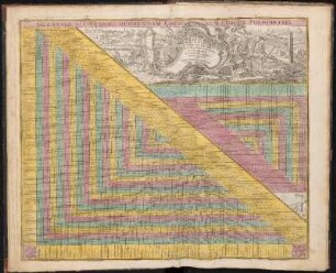
Altkarte
Plan von Constantinopel, mit der umliegenden Gegend, und des Canals vom Schwarzen Meer : = Plan de la Ville de Constantinople, des Places voisines, et du Canal de Pont Euxine
- Weitere Titel
-
Plan de la Ville de Constantinople, des Places voisines, et du Canal de Pont Euxine
- Standort
-
München, Bayerische Staatsbibliothek -- 2 Mapp. 6-8
- Maße
-
54 x 38 cm, Bildgr. 54 x 48 cm
- Umfang
-
1 Kt.
- Sprache
-
Deutsch
- Anmerkungen
-
Kupferstich
O oben. - Mit 1 Stadtansicht: Constantinopel
- Erschienen in
-
Atlas maior sive collectio mapparum diversorum autoribus / 8 ; 30
- Schlagwort
-
Vedute
Konstantinopel
Konstantinopel
Bosporus-Gebiet
- Ereignis
-
Veröffentlichung
- (wo)
-
Augsburg
- (wer)
-
Tob. Conr. Lotter
- (wann)
-
1770
- Beteiligte Personen und Organisationen
- URN
-
urn:nbn:de:bvb:12-bsb00002277-9
- Letzte Aktualisierung
-
16.04.2025, 08:52 MESZ
Datenpartner
Dieses Objekt wird bereitgestellt von:
Bayerische Staatsbibliothek. Bei Fragen zum Objekt wenden Sie sich bitte an den Datenpartner.
Bayerische Staatsbibliothek. Bei Fragen zum Objekt wenden Sie sich bitte an den Datenpartner.
Objekttyp
- Altkarte
Beteiligte
- Lotter, Tobias Conrad
- Tob. Conr. Lotter
Entstanden
- 1770
Ähnliche Objekte (12)
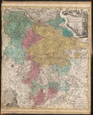
L'Electorat de Hannover : ou Les Duchés du Lunebourg, de Bremen et de Ferden etc. c'est à dire Les Domaines Du Roi De La Grand Bretagne En Allemagne
Topographia Sedis Imperatoriae Moscovitarum Petropolis : anno 1744 designata iam publici iuris facta ; Cum Grat. et Privil. S. R. I. Vicariatus, in part. Rheni, Sveviae, et Iur. Franc. = Plan der Kayserlichen Residentz-Stadt Sankt Petersburg
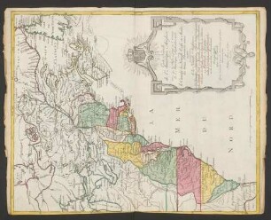
Carte Nouvelle de l'Amerique Angloise : contenant tout ce que les Anglois possedent sur le Continent de l'Amerique Septentrionale Savoir le Canada, la Nouvelle Ecosse ou Acadie, les treize Provinces unies qui sont: les quatres Colonies de la Nouvelle Angleterre 1. New Hampshire, 2. Massachusetsbaye, 3. Rhode-Island, & 4. Conecticut, 5. la Nouvelle York, 6. Nouvelle Jersey, 7. Pensilvanie, 8. les Comtés de Newcastle Kent et Sussex sur la Delaware, 9. Mariland, 10. Virginie, 11. la Caroline Septentrionale, 12. la Caroline Meridionale et 13. Georgie: avec la Floride
Superioris atque inferioris Alsatiae
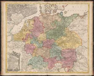
Nova Et Exacta Mappa Geographica exhibens Circulum Westphalicum
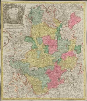
Ducatus Wurtembergici cum Territoriis conterminis
![XVII. Provinciæ Belgii sive Germaniæ Inferioris priscis temporib[us] Circulo Burgundico S.R.I. annumeratæ quarum X. hodie maximam partem Hispaniarum non nullæ Galliæ Regis ditioni subjacent, VII. vero sub nomine Foederatarum Provinciar libertate gaudent](https://iiif.deutsche-digitale-bibliothek.de/image/2/411ef080-9f0a-4b2b-870f-49ae5ced3b36/full/!306,450/0/default.jpg)
XVII. Provinciæ Belgii sive Germaniæ Inferioris priscis temporib[us] Circulo Burgundico S.R.I. annumeratæ quarum X. hodie maximam partem Hispaniarum non nullæ Galliæ Regis ditioni subjacent, VII. vero sub nomine Foederatarum Provinciar libertate gaudent
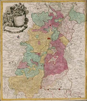
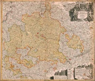
Circulus Franconicus
Mappa Geographica exhibens Postas omnes tam vehiculares quam veredarias Totius Germaniæ : cum earum accurata distantia
Germaniae Aliorumque Quorundam Loco-rum Europae Poliometria
Globus Terrestris ad sphaeram obliquam delineatus. Globus Coelestis cum Astrodictico artificiali iunctus - B 49

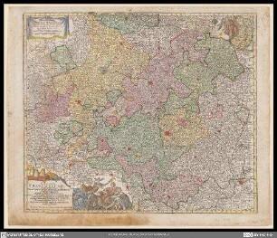
Geographia Silesiae, 0
L'Electorat de Hannover : ou Les Duchés du Lunebourg, de Bremen et de Ferden etc. c'est à dire Les Domaines Du Roi De La Grand Bretagne En Allemagne
Topographia Sedis Imperatoriae Moscovitarum Petropolis : anno 1744 designata iam publici iuris facta ; Cum Grat. et Privil. S. R. I. Vicariatus, in part. Rheni, Sveviae, et Iur. Franc. = Plan der Kayserlichen Residentz-Stadt Sankt Petersburg
Carte Nouvelle de l'Amerique Angloise : contenant tout ce que les Anglois possedent sur le Continent de l'Amerique Septentrionale Savoir le Canada, la Nouvelle Ecosse ou Acadie, les treize Provinces unies qui sont: les quatres Colonies de la Nouvelle Angleterre 1. New Hampshire, 2. Massachusetsbaye, 3. Rhode-Island, & 4. Conecticut, 5. la Nouvelle York, 6. Nouvelle Jersey, 7. Pensilvanie, 8. les Comtés de Newcastle Kent et Sussex sur la Delaware, 9. Mariland, 10. Virginie, 11. la Caroline Septentrionale, 12. la Caroline Meridionale et 13. Georgie: avec la Floride
Superioris atque inferioris Alsatiae
Nova Et Exacta Mappa Geographica exhibens Circulum Westphalicum
Ducatus Wurtembergici cum Territoriis conterminis
XVII. Provinciæ Belgii sive Germaniæ Inferioris priscis temporib[us] Circulo Burgundico S.R.I. annumeratæ quarum X. hodie maximam partem Hispaniarum non nullæ Galliæ Regis ditioni subjacent, VII. vero sub nomine Foederatarum Provinciar libertate gaudent
Circulus Franconicus
Mappa Geographica exhibens Postas omnes tam vehiculares quam veredarias Totius Germaniæ : cum earum accurata distantia
Germaniae Aliorumque Quorundam Loco-rum Europae Poliometria
Globus Terrestris ad sphaeram obliquam delineatus. Globus Coelestis cum Astrodictico artificiali iunctus - B 49