Altkarte
Videbis totius Greciãe limites diuisos per mōtes flumina & maria nominib. hodiernis, ad hunc modū
- Alternative title
-
Videbis totius Greciae limites divisos per montes flumina et maria, nominib. hodiernis, ad hunc modum
- Location
-
Dillingen, Studienbibliothek -- X 123#Nr.113
- Dimensions
-
39 x 50 cm
- Extent
-
1 Karte
- Language
-
Latein
- Notes
-
Kupferstich
Maßstab in grafischer Form (Milliaria, Stadia)
Literatur: Karrow, Robert: Mapmakers of the sixteenth century and their maps, 1993, Nr. 51/10.1
- Bibliographic citation
-
[Lafreri-Atlas der Studienbibliothek Dillingen X,123] ; [113]
- Keyword
-
Griechenland
- Event
-
Veröffentlichung
- (where)
-
[Antverpiae]
- (who)
-
[Gerard de Jode]
- (when)
-
[Circa 1578]
- Contributor
- URN
-
urn:nbn:de:bvb:12-bsb00106735-8
- Last update
-
16.04.2025, 8:32 AM CEST
Data provider
This object is provided by:
Bayerische Staatsbibliothek. If you have any questions about the object, please contact the data provider.
Bayerische Staatsbibliothek. If you have any questions about the object, please contact the data provider.
Object type
- Altkarte
Associated
- Jode, Gérard de
- [Gerard de Jode]
Time of origin
- [Circa 1578]
Other Objects (12)
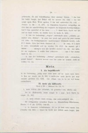
Mote.
MOteL

Motes, Alfred
MoTE
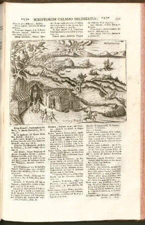
Mõte Vesvvio
Motes históricos
Männertanz <sang mote>
Ightham Mote, Kent
Motes de naciones
Ad Flumina
Super flumina
Super flumina
Mote.
MOteL
Motes, Alfred
MoTE
Mõte Vesvvio
Motes históricos
Männertanz <sang mote>
Ightham Mote, Kent
Motes de naciones
Ad Flumina
Super flumina
Super flumina
Mote.
MOteL
Motes, Alfred
MoTE
Mõte Vesvvio
Motes históricos
Männertanz <sang mote>
Ightham Mote, Kent
Motes de naciones
Ad Flumina
Super flumina