- Archivaliensignatur
-
RW Karten, 6675
- Maße
-
Maßstab: 1 : 320.000
- Bemerkungen
-
Nebenkarten: Ile de Jersey 1 : 320.000, 10 x 9 cm. - Westliche Umgegend von Paris 1 : 500.000, 16 x 20 cm
- Kontext
-
RW Karten >> 8. Verkehr >> 8.4. Fremdenverkehr >> 8.4.2. Ausland
- Bestand
-
RW Karten
- Laufzeit
-
[ca. 1910] 85 x 60 cm
- Weitere Objektseiten
- Provenienz
-
Diverse Registraturbildner
- Geliefert über
- Letzte Aktualisierung
- 09.01.2026, 11:38 MEZ
Datenpartner
Dieses Objekt wird bereitgestellt von:
Landesarchiv Nordrhein-Westfalen. Abteilung Rheinland. Bei Fragen zum Objekt wenden Sie sich bitte an den Datenpartner.
Landesarchiv Nordrhein-Westfalen. Abteilung Rheinland. Bei Fragen zum Objekt wenden Sie sich bitte an den Datenpartner.
Objekttyp
- Karten / Pläne
Entstanden
- [ca. 1910] 85 x 60 cm
Ähnliche Objekte (12)
![Carte-Guide Campbell Nr. 12-Gironde [Karte und Guide pratique].](https://iiif.deutsche-digitale-bibliothek.de/image/2/67a87966-c792-44fc-b9a5-beaf99b5b13f/full/!306,450/0/default.jpg)
Carte-Guide Campbell Nr. 12-Gironde [Karte und Guide pratique].
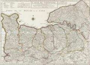
Carte de Normandie
Carte de Normandie
![Carte-Guide Campbell Nr.13- Pyrénées. Bayonne [Karte und Guide pratique]. Gravé et imp. par Dufrenoy, Paris](https://iiif.deutsche-digitale-bibliothek.de/image/2/7fcf3c31-a050-4c0d-a761-7299c95f7b38/full/!306,450/0/default.jpg)
Carte-Guide Campbell Nr.13- Pyrénées. Bayonne [Karte und Guide pratique]. Gravé et imp. par Dufrenoy, Paris
![Carte-Guide Campbell Nr. 6-Centre [Fontainebleau-Clermont-Ferrand. Karte und Guide pratique]. Imp. par Erhard Fres, Paris](https://iiif.deutsche-digitale-bibliothek.de/image/2/0cdd8a6d-5c8e-4867-b9b4-a38cfe6e8e04/full/!306,450/0/default.jpg)
Carte-Guide Campbell Nr. 6-Centre [Fontainebleau-Clermont-Ferrand. Karte und Guide pratique]. Imp. par Erhard Fres, Paris
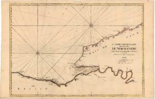
Carte Particulière des Costes de Normandie

Guides

Guides

Normandie, ?. Aufl., Clermont-Ferrand 1984: Michelin (Les Guides Verts Michelin/Guide de Tourisme)
Karte der herzoglich württembergischen Geleitstraßen von Neuenstadt, angefertigt vom Corps de Guides
Campbell
Campbell
Carte-Guide Campbell Nr. 12-Gironde [Karte und Guide pratique].
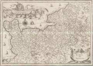
Carte de Normandie
Carte de Normandie
Carte-Guide Campbell Nr.13- Pyrénées. Bayonne [Karte und Guide pratique]. Gravé et imp. par Dufrenoy, Paris
Carte-Guide Campbell Nr. 6-Centre [Fontainebleau-Clermont-Ferrand. Karte und Guide pratique]. Imp. par Erhard Fres, Paris
Carte Particulière des Costes de Normandie
Guides
Guides
Normandie, ?. Aufl., Clermont-Ferrand 1984: Michelin (Les Guides Verts Michelin/Guide de Tourisme)
Karte der herzoglich württembergischen Geleitstraßen von Neuenstadt, angefertigt vom Corps de Guides
Campbell
Campbell
Carte-Guide Campbell Nr. 12-Gironde [Karte und Guide pratique].
Carte de Normandie
Carte de Normandie
Carte-Guide Campbell Nr.13- Pyrénées. Bayonne [Karte und Guide pratique]. Gravé et imp. par Dufrenoy, Paris
Carte-Guide Campbell Nr. 6-Centre [Fontainebleau-Clermont-Ferrand. Karte und Guide pratique]. Imp. par Erhard Fres, Paris
Carte Particulière des Costes de Normandie
Guides
Guides
Normandie, ?. Aufl., Clermont-Ferrand 1984: Michelin (Les Guides Verts Michelin/Guide de Tourisme)
Karte der herzoglich württembergischen Geleitstraßen von Neuenstadt, angefertigt vom Corps de Guides
Campbell