Karte
Griechenland und der Griechisch-Türkische Archipel : Im Maassstabe von 1:1.850.000
- Location
-
Leibniz-Institut für Länderkunde e.V., Leipzig
- Collection
-
Collection Alphons Stübel
- Other number(s)
-
HK 1624 (Signatur)
- Material/Technique
-
Grenzen kolor.
- Inscription/Labeling
-
Aus: Stieler's Hand-Atlas, 38 / Adolf Stieler. - Maßstab in graph. Form (Deutsche geographische Meilen). - Titel, Maßstab, Erkl. der Farben u. Erkl. der Zeichen oben links. - Abkürzungsverz. unten links. - Mit 3 Nebenkt.: Santorin oder Thera. Insel Syra. Athen und Umgebung. - Relief: Schraffen
- Subject (what)
-
Altkarte
Physische Karte
Griechenland
Ägäis
- Event
-
Veröffentlichung
- (who)
-
Justus Perthes (Verlag)
- (where)
-
Gotha
- (when)
-
1867
- Rights
-
Leibniz-Institut für Länderkunde e.V.
- Last update
-
15.05.2025, 12:43 PM CEST
Data provider
This object is provided by:
Leibniz-Institut für Länderkunde e. V.. If you have any questions about the object, please contact the data provider.
Leibniz-Institut für Länderkunde e. V.. If you have any questions about the object, please contact the data provider.
Object type
- Karte
Associated
- Justus Perthes (Verlag)
Time of origin
- 1867
Other Objects (12)
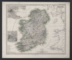
Ireland : im Maassstabe von 1:1 500 000

Palästina im Maassstabe von 1:1.200.000

Indien & Inner-Asien : in 2 Blättern, im Maassstabe von 1:7.500.000
Ostindischer Archipel, ganz und größere Teile : 1920 : Kartensammlung

Ostindischer Archipel, ganz und größere Teile : 1842 : Kartensammlung
Ostindischer Archipel, ganz und größere Teile : 1892-1902 : Kartensammlung
Ostindischer Archipel, ganz und größere Teile : 1836-1893 : Kartensammlung
Ostindischer Archipel, ganz und größere Teile : 1827-1914 : Kartensammlung
Ostindischer Archipel, ganz und größere Teile : 1869-1881 : Kartensammlung
Ostindischer Archipel, ganz und größere Teile : 1889-1891 : Kartensammlung
![Königreich Griechenland und die Ionischen Inseln [Hand-Atlas über alle Theile der Erde nach dem neuesten Zustande und über das Weltgebäude]](https://iiif.deutsche-digitale-bibliothek.de/image/2/459c05f4-2f0b-4b77-9f5b-77d526c5e643/full/!306,450/0/default.jpg)
Königreich Griechenland und die Ionischen Inseln [Hand-Atlas über alle Theile der Erde nach dem neuesten Zustande und über das Weltgebäude]

China (Östl. Theil), Korea und Japan im Maassstabe von 1:7.500.000
Ireland : im Maassstabe von 1:1 500 000
Palästina im Maassstabe von 1:1.200.000
Indien & Inner-Asien : in 2 Blättern, im Maassstabe von 1:7.500.000
Ostindischer Archipel, ganz und größere Teile : 1920 : Kartensammlung
Ostindischer Archipel, ganz und größere Teile : 1842 : Kartensammlung
Ostindischer Archipel, ganz und größere Teile : 1892-1902 : Kartensammlung
Ostindischer Archipel, ganz und größere Teile : 1836-1893 : Kartensammlung
Ostindischer Archipel, ganz und größere Teile : 1827-1914 : Kartensammlung
Ostindischer Archipel, ganz und größere Teile : 1869-1881 : Kartensammlung
Ostindischer Archipel, ganz und größere Teile : 1889-1891 : Kartensammlung
Königreich Griechenland und die Ionischen Inseln [Hand-Atlas über alle Theile der Erde nach dem neuesten Zustande und über das Weltgebäude]