Altkarte
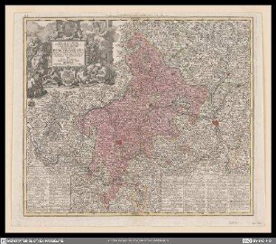
Mappa Geographica Circuli Metalliferi Electoratus Saxoniae : cum omnibus, quae in eo comprehenduntur Praefecturis, quales sunt ; Cum Priv. S. M. Polon. et Elect. Saxon.
- Location
-
München, Bayerische Staatsbibliothek -- 2 Mapp. 6-5
- Dimensions
-
Gesamtgr. 96 x 56 cm, je Teil 48 x 46 cm
- Extent
-
1 Kt. auf 2 Bl.
- Notes
-
Kupferstich
Maßstab in graph. Form (Milliaria communia, milliaria Saxonica majora). - Titelkartusche oben links. - Mit d. Abb. e. Bergwerkes
- Bibliographic citation
-
Atlas maior sive collectio mapparum diversorum autoribus / 5 ; 43/44
- Series
-
Atlas maior sive collectio mapparum diversorum autoribus / 5; 43/44
- Keyword
-
Geschichte 1547-1806
Bergbau
Sachsen
- Event
-
Veröffentlichung
- (where)
-
Aug. Vind.//Augsburg//
- (when)
-
s.a. [zwischen 1740 u. 1760]
- Contributor
- URN
-
urn:nbn:de:bvb:12-bsb00083002-0
- Last update
-
27.11.2025, 8:40 AM CET
Data provider
This object is provided by:
Bayerische Staatsbibliothek. If you have any questions about the object, please contact the data provider.
Bayerische Staatsbibliothek. If you have any questions about the object, please contact the data provider.
Object type
- Altkarte
Time of origin
- s.a. [zwischen 1740 u. 1760]
Other Objects (12)
Nova et accuratior repraesentatio geographica Sacr. Rom. Imperii episcopatus Wirceburgensis Franciae Orientalis ducatus cum omnibus suis praefecturis et ditionibus eo pertinentibus etc.

Electoratus Hanoverani cum ditionibus et praefecturis suis nova et accurata delineatio

Ducatus Wurtembergici cum Territoriis conterminis
Novissima et accurata Tabula Geographica Principalis Sancti R. I. Praepositurae Ellevacensis cum suis Praefecturis atque locis eò pertinentibus

Globus Terrestris ad sphaeram obliquam delineatus. Globus Coelestis cum Astrodictico artificiali iunctus - B 49
Mappa Geographica exhibens Postas omnes tam vehiculares quam veredarias Totius Germaniæ : cum earum accurata distantia

Borussiae Regnum : complectens Circulos Sambiensem, Natangiensem et Hockerlandiae Nec non Borussia Polonica exhibens Palatinatus Culmiensem, Marienburgensem, Pomerelliae et Varmiae Cum adjacentibus aliis Provinciis

Historia Circuli Bavarici, Nec Non Finitimarum Ac Insertarum Regionum : Cum Grat. et Priv. S. R. I. Vicar. in part. Rheni Svev. et Juris Francon.
Spatiosissimum Imperium Russiæ Magnæ juxta recentissimas Observationes Mappa Geographica : Cum Gratia et Privil. S. R. I. Vicariatus, in partibus Rheni, Sueviæ, et Juris Franconici

Topographia Sedis Imperatoriae Moscovitarum Petropolis : anno 1744 designata iam publici iuris facta ; Cum Grat. et Privil. S. R. I. Vicariatus, in part. Rheni, Sveviae, et Iur. Franc. = Plan der Kayserlichen Residentz-Stadt Sankt Petersburg

Tabula Synoptica Totius Fluminis Danubii A Fontibus Usque Ad Ostia - R 18 : in qua omnes regiones, quas perfluit et amnes, quos recipit, Imprimis Integrum Hungariae Regnum, Principat. Transilvaniae, Moldaviae, Walachiae, Archiducatus Austriae, Regna Et Ducat. Styriae, Carinthiae, Carniolae, Croatiae, Dalmatiae, Sclavoniae, Bosniae, Bessarabiae, Bulgariae, Romaniae, Cum Magna Parte Turciae Et Tartariae &c. &c. Nec Non Mare Adriaticum Et Pontus Euxinus Oculis Sistuntur; Cum Gratia et Privil. S. R. I. Vicariatus, in partibus Rheni, Sueviae, et Iuris Franconicii

Geographische Abzeichnung der in dem Meisnischen Creiß des Churfürstenthumbs Sachsen Liegenden Dioeces oder Superintendtur Grossen Hayn : Sambt ihren Staetten, Flecken und Dorffschafften in welcher gegend Ihro Konigl. Maj. in Pohl. u. Churfurstl. Durchl. zu Sachsen Fridericus Augustus im Monat Maj und Iunio A 1730 Beÿ dem Großen u. verwunderungs-würdigen Campement Dero gesamten Saechsischen Armee, nelbst denen Anwesenden Höchsten und Hohen Königlich. u. Fürstlich. auch andern Grossen Standes-Persohnen Dero Quartier genohmen ; Cum Gratia et Privil. S. I. R. Vicariatus, in partibus Rheni, Sveviae, et Juris Franconici
Nova et accuratior repraesentatio geographica Sacr. Rom. Imperii episcopatus Wirceburgensis Franciae Orientalis ducatus cum omnibus suis praefecturis et ditionibus eo pertinentibus etc.
Electoratus Hanoverani cum ditionibus et praefecturis suis nova et accurata delineatio
Ducatus Wurtembergici cum Territoriis conterminis
Novissima et accurata Tabula Geographica Principalis Sancti R. I. Praepositurae Ellevacensis cum suis Praefecturis atque locis eò pertinentibus
Globus Terrestris ad sphaeram obliquam delineatus. Globus Coelestis cum Astrodictico artificiali iunctus - B 49
Mappa Geographica exhibens Postas omnes tam vehiculares quam veredarias Totius Germaniæ : cum earum accurata distantia
Borussiae Regnum : complectens Circulos Sambiensem, Natangiensem et Hockerlandiae Nec non Borussia Polonica exhibens Palatinatus Culmiensem, Marienburgensem, Pomerelliae et Varmiae Cum adjacentibus aliis Provinciis
Historia Circuli Bavarici, Nec Non Finitimarum Ac Insertarum Regionum : Cum Grat. et Priv. S. R. I. Vicar. in part. Rheni Svev. et Juris Francon.
Spatiosissimum Imperium Russiæ Magnæ juxta recentissimas Observationes Mappa Geographica : Cum Gratia et Privil. S. R. I. Vicariatus, in partibus Rheni, Sueviæ, et Juris Franconici
Topographia Sedis Imperatoriae Moscovitarum Petropolis : anno 1744 designata iam publici iuris facta ; Cum Grat. et Privil. S. R. I. Vicariatus, in part. Rheni, Sveviae, et Iur. Franc. = Plan der Kayserlichen Residentz-Stadt Sankt Petersburg
Tabula Synoptica Totius Fluminis Danubii A Fontibus Usque Ad Ostia - R 18 : in qua omnes regiones, quas perfluit et amnes, quos recipit, Imprimis Integrum Hungariae Regnum, Principat. Transilvaniae, Moldaviae, Walachiae, Archiducatus Austriae, Regna Et Ducat. Styriae, Carinthiae, Carniolae, Croatiae, Dalmatiae, Sclavoniae, Bosniae, Bessarabiae, Bulgariae, Romaniae, Cum Magna Parte Turciae Et Tartariae &c. &c. Nec Non Mare Adriaticum Et Pontus Euxinus Oculis Sistuntur; Cum Gratia et Privil. S. R. I. Vicariatus, in partibus Rheni, Sueviae, et Iuris Franconicii