Verzeichnung
Die Nordseeküste von Rottum bis Norderney mit Einzeichnung der Wassertiefen und der Emsmündung Druck von G. Dempwolff Papier auf Leinen Format 157,8x65,0 M 1:50.000 (ca)
- Reference number
-
NLA HA, Rep. 244, C Nr. 571
- Former reference number
-
Rep. 244, 2572 C
Rep. 244 C 2572
- Context
-
Kartensammlung >> 8 Europa >> 1 Europa >> 10 Gewässer, Kanäle, Seekarten
- Holding
-
Rep. 244 Kartensammlung
- Indexbegriff subject
-
Inseln Rottum/Norderney, Nordseeküste
- Indexentry person
-
Dempwolff, G.
- Indexentry place
-
Emsmündung, Wassertiefen
Norderney/Rottum, Nordseeküste
Nordseeküste, Rottum/Norderney
Rottum/Norderney, Nordseeküste
- Date of creation
-
- 1861
- Other object pages
- Last update
-
16.06.2025, 1:30 PM CEST
Data provider
This object is provided by:
Niedersächsisches Landesarchiv. If you have any questions about the object, please contact the data provider.
Niedersächsisches Landesarchiv. If you have any questions about the object, please contact the data provider.
Object type
- Verzeichnung
Time of origin
- - 1861
Other Objects (12)

Karte der Emsmündung mit Angabe der Wassertiefen und von Strömungen
Faszination Nordseeküste - Norderney
Die niederländische Nordseeküste : Westerschelde bis Emsmündung ; Handbuch für die Sportschiffahrt
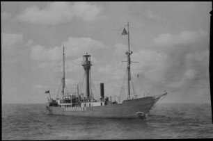
Helgoländer Bucht, Feuerschiff Norderney auf Position zwischen Weser- und Emsmündung
Wegpunkte der Nordsee : Ramsgate - Wash - Cap Gris - Ems-Mündung - deutsche Nordseeküste - Esbjerg
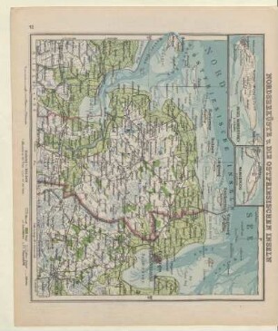
Nordseeküste u. die Ostfriesischen Inseln, Insel Norderney, Wangeroog
Karte der Emsmündung und der niederländischen Nordseeküste mit Einzeichnung der Wassertiefen Druck herausgegeben von der königlichen Generaldirektion des Wasserbaus, Hannover Druck von C. v. Castell, Hannover Papier Format 76,0x61,0 M 1:50.000
Schiff, (Senkblei für Wassertiefen)
Wellenmessungen auf verschiedenen Wassertiefen
Die Nordseeküste von der Insel Schiermonnikoog bis nach Norderney mit Einzeichnung der Wassertiefen Druck herausgegeben vom Hydrographischen Amt der Admiralität, Berlin Papier Format 74,2x75,0 M 1:100.000
Rottum
Rottum
Karte der Emsmündung mit Angabe der Wassertiefen und von Strömungen
Faszination Nordseeküste - Norderney
Die niederländische Nordseeküste : Westerschelde bis Emsmündung ; Handbuch für die Sportschiffahrt
Helgoländer Bucht, Feuerschiff Norderney auf Position zwischen Weser- und Emsmündung
Wegpunkte der Nordsee : Ramsgate - Wash - Cap Gris - Ems-Mündung - deutsche Nordseeküste - Esbjerg
Nordseeküste u. die Ostfriesischen Inseln, Insel Norderney, Wangeroog
Karte der Emsmündung und der niederländischen Nordseeküste mit Einzeichnung der Wassertiefen Druck herausgegeben von der königlichen Generaldirektion des Wasserbaus, Hannover Druck von C. v. Castell, Hannover Papier Format 76,0x61,0 M 1:50.000
Schiff, (Senkblei für Wassertiefen)
Wellenmessungen auf verschiedenen Wassertiefen
Die Nordseeküste von der Insel Schiermonnikoog bis nach Norderney mit Einzeichnung der Wassertiefen Druck herausgegeben vom Hydrographischen Amt der Admiralität, Berlin Papier Format 74,2x75,0 M 1:100.000
Rottum