Altkarte | Stadtplan
Abbildung der Keys. Freyen- Reichs- Wahl- und Handelstatt Franckfurt Am Mayn Mit Ihrem Gebiet und Gräntzen : Cum Privilegio Sac. Caes. Majestatis
- Alternative title
-
Abbildung der Keyserlichen Freyen-, Reichs-, Wahl-, und Handelstatt Franckfurt Am Mayn Mit Ihrem Gebiet und Gräntzen
- Location
-
München, Bayerische Staatsbibliothek -- 2 Mapp. 8-3,1
- Dimensions
-
56 x 47 cm
- Extent
-
1 Kt.
- Notes
-
Kupferstich
Maßstab in graph. Form (Gemeine Teutsche Meil). - Mit 1 Stadtansicht u. 2 bildl. Darstellungen. - Titel oben
- Bibliographic citation
-
Atlas Selectus / 3 ; 152
- Series
-
Atlas Selectus / 3; 152
- Keyword
-
Territorium
Frankfurt am Main
Frankfurt am Main
- Event
-
Veröffentlichung
- (where)
-
Nürnberg
- (when)
-
s.a. [nach 1715]
- Contributor
- URN
-
urn:nbn:de:bvb:12-bsb00080389-4
- Last update
-
27.11.2025, 8:35 AM CET
Data provider
This object is provided by:
Bayerische Staatsbibliothek. If you have any questions about the object, please contact the data provider.
Bayerische Staatsbibliothek. If you have any questions about the object, please contact the data provider.
Object type
- Altkarte
- Stadtplan
Associated
Time of origin
- s.a. [nach 1715]
Other Objects (12)
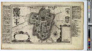
Ypra : Cum Gr. et Privilegio Sac. Caes. Majestatis
![Abbildung der Keys[e]rl[ichen] Freyen-Reichs-Wahl-und Handelsstatt Franckfurt Am Mayn. Mit ihrem Gebiet und Gräntzen vorgestelt von Joh[ann] Baptist Homann. Cum Privilegio Sac. Caes. Majestatis.](https://iiif.deutsche-digitale-bibliothek.de/image/2/5b8752c9-d15f-4e31-9111-eb654c7a9be2/full/!306,450/0/default.jpg)
Abbildung der Keys[e]rl[ichen] Freyen-Reichs-Wahl-und Handelsstatt Franckfurt Am Mayn. Mit ihrem Gebiet und Gräntzen vorgestelt von Joh[ann] Baptist Homann. Cum Privilegio Sac. Caes. Majestatis.

Totius Regni Galliæ Sive Franciæ Tabula : Cum Privilegio Sac. Cæs. Majestatis

Sac. Caesar. Majestatis Privilegium

Sac: Caesar: Majestatis Privilegium

Sac. Caesar. Majestatis Privilegium
![Regnorum Hispaniæ et Portugalliæ Tabula Generalis ; Cum Privilegio Sac. Cæs. Majest[a]tis](https://iiif.deutsche-digitale-bibliothek.de/image/2/6b711ec2-2585-4825-bae6-a0c7ba6943b0/full/!306,450/0/default.jpg)
Regnorum Hispaniæ et Portugalliæ Tabula Generalis ; Cum Privilegio Sac. Cæs. Majest[a]tis
![[Ratificatio Suæ Sac. ... - Ratificatio Suæ Majestatis ...]](https://iiif.deutsche-digitale-bibliothek.de/image/2/d68bcfe8-70a1-4775-8857-38f5faca2933/full/!306,450/0/default.jpg)
[Ratificatio Suæ Sac. ... - Ratificatio Suæ Majestatis ...]
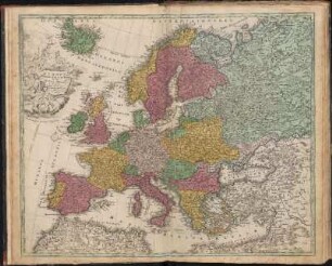
Europa Christiani Orbis Domina : In Sua Imperia Regna Et Status exacte divisa ; Cum Privilegio Sac. Cæs. Majestatis

Lithuania Borussica : Cum Privilegio Sac. Caes. Maiestatis
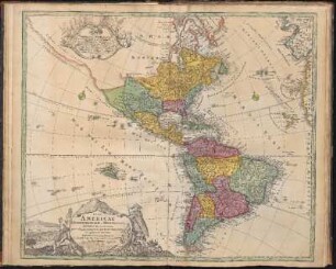
Totius Americae Septentrionalis Et Meridionalis Novissima Repræsentatio : quam ex singulis recentium Geographorum Tabulis collectam ; Cum Privilegio Sac. Cæs. Majestatis
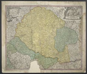
Regni Hungariae Tabula Generalis : Cum Privilegio Sacrae Caesarea Majestatis
Ypra : Cum Gr. et Privilegio Sac. Caes. Majestatis
Abbildung der Keys[e]rl[ichen] Freyen-Reichs-Wahl-und Handelsstatt Franckfurt Am Mayn. Mit ihrem Gebiet und Gräntzen vorgestelt von Joh[ann] Baptist Homann. Cum Privilegio Sac. Caes. Majestatis.
Totius Regni Galliæ Sive Franciæ Tabula : Cum Privilegio Sac. Cæs. Majestatis
Sac. Caesar. Majestatis Privilegium
Sac: Caesar: Majestatis Privilegium
Sac. Caesar. Majestatis Privilegium
Regnorum Hispaniæ et Portugalliæ Tabula Generalis ; Cum Privilegio Sac. Cæs. Majest[a]tis
[Ratificatio Suæ Sac. ... - Ratificatio Suæ Majestatis ...]
Europa Christiani Orbis Domina : In Sua Imperia Regna Et Status exacte divisa ; Cum Privilegio Sac. Cæs. Majestatis
Lithuania Borussica : Cum Privilegio Sac. Caes. Maiestatis
Totius Americae Septentrionalis Et Meridionalis Novissima Repræsentatio : quam ex singulis recentium Geographorum Tabulis collectam ; Cum Privilegio Sac. Cæs. Majestatis