Karten und Pläne
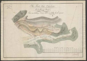
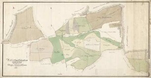
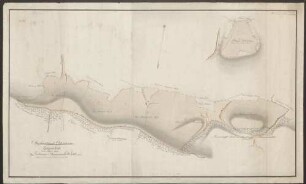
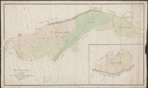
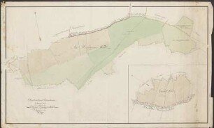
Plan der Wald-Angellocher Gemeinds-Waldung im Ober-Forst-Amt Odenheim Eichelberger Forst
Forstgrenzkarte wie Nr. 5, 1. Die einzelnen Distrikte mit schwarzen Rahmen.
- Reference number
-
Abt. Generallandesarchiv Karlsruhe, H Waldangelloch 5, 2
- Dimensions
-
44,5 x 63 (Höhe x Breite)
- Notes
-
Zugang 1891-37
- Further information
-
Ausführung: Handzeichnung
Orientierung: NNW
Originalmaßstab: 140/150 Ruten, 10 = 1,1 cm, Scala 4 c = 1:4 000 ?
- Context
-
Gemarkungspläne >> Badische Orte >> W >> Waldangelloch, Stadt Sinsheim, HD
- Holding
-
Landesarchiv Baden-Württemberg, Abt. Generallandesarchiv Karlsruhe, H Gemarkungspläne
- Creator
-
Autor/Fotograf: ?
- Date of creation
-
1807
- Other object pages
- View digital item at providers-website
- Rights
-
Es gelten die Nutzungsbedingungen des Landesarchivs Baden-Württemberg.
- Last update
-
04.04.2025, 8:09 AM CEST
Data provider
This object is provided by:
Landesarchiv Baden-Württemberg. If you have any questions about the object, please contact the data provider.
Landesarchiv Baden-Württemberg. If you have any questions about the object, please contact the data provider.
Object type
- Karten und Pläne
Associated
- Autor/Fotograf: ?
Time of origin
- 1807
Other Objects (12)
Ober-Forst-Amt Odenheim, Eichelberger Revier
Oberforstamt Odenheim. Mingolsheimer Forst. Die Mingolsheimer Gemeinds-Waldungen
Oberforstamt Odenheim. Zeiterner Forst. Die Ubstadter Gemeinds-Waldungen
Oberforstamt Odenheim Mingolsheimer Forst. Die Langenbrücker Gemeinds-Waldungen
Oberforstamt Odenheim. Mühlhaeuser Forst. Ein Theil der Östringer Gemeinds-Waldungen
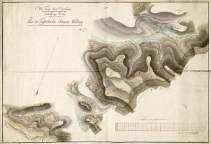
Ober-Forst-Amt Odenheim. Eichelberger Revier. Plan der Tieffenbacher Commun-Waldungen
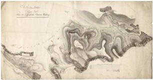
Ober-Forst-Amt Odenheim. Eichelberger Revier. Plan der Tieffenbacher Commun-Waldungen
Plan der Wald-Angellocher Gemeinds-Waldung im Ober-Forst-Amt Odenheim Eichelber Forst
Oberforstamt Odenheim. Zeiterner Forst. Ein Theil der Zeitener Gemeinds Waldungen. IV Plan Lit. B
Oberforstamt Odenheim. Zeiterner Forst. Ein Theil der Zeiterner Gemeinds Waldungen. IV Plan Lit. C
Oberforstamt Odenheim. Zeiterner Forst. Ein Theil der Zeiterner Gemeinds Waldungen. IV Plan Lit. C

Oberforstamt Odenheim. Zeiterner Forst, Plan Lit.ra D. Ein Theil der Zeiterner Gemeinds-Waldungen. Odenheimer Forst Lit.ra A. Ein Theil der Oberöwisheimer Gemeinds-Waldungen
Ober-Forst-Amt Odenheim, Eichelberger Revier
Oberforstamt Odenheim. Mingolsheimer Forst. Die Mingolsheimer Gemeinds-Waldungen
Oberforstamt Odenheim. Zeiterner Forst. Die Ubstadter Gemeinds-Waldungen
Oberforstamt Odenheim Mingolsheimer Forst. Die Langenbrücker Gemeinds-Waldungen
Oberforstamt Odenheim. Mühlhaeuser Forst. Ein Theil der Östringer Gemeinds-Waldungen
Ober-Forst-Amt Odenheim. Eichelberger Revier. Plan der Tieffenbacher Commun-Waldungen
Ober-Forst-Amt Odenheim. Eichelberger Revier. Plan der Tieffenbacher Commun-Waldungen
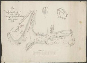
Plan der Wald-Angellocher Gemeinds-Waldung im Ober-Forst-Amt Odenheim Eichelber Forst
Oberforstamt Odenheim. Zeiterner Forst. Ein Theil der Zeitener Gemeinds Waldungen. IV Plan Lit. B
Oberforstamt Odenheim. Zeiterner Forst. Ein Theil der Zeiterner Gemeinds Waldungen. IV Plan Lit. C
Oberforstamt Odenheim. Zeiterner Forst. Ein Theil der Zeiterner Gemeinds Waldungen. IV Plan Lit. C
Oberforstamt Odenheim. Zeiterner Forst, Plan Lit.ra D. Ein Theil der Zeiterner Gemeinds-Waldungen. Odenheimer Forst Lit.ra A. Ein Theil der Oberöwisheimer Gemeinds-Waldungen
Ober-Forst-Amt Odenheim, Eichelberger Revier
Oberforstamt Odenheim. Mingolsheimer Forst. Die Mingolsheimer Gemeinds-Waldungen
Oberforstamt Odenheim. Zeiterner Forst. Die Ubstadter Gemeinds-Waldungen
Oberforstamt Odenheim Mingolsheimer Forst. Die Langenbrücker Gemeinds-Waldungen
Oberforstamt Odenheim. Mühlhaeuser Forst. Ein Theil der Östringer Gemeinds-Waldungen
Ober-Forst-Amt Odenheim. Eichelberger Revier. Plan der Tieffenbacher Commun-Waldungen
Ober-Forst-Amt Odenheim. Eichelberger Revier. Plan der Tieffenbacher Commun-Waldungen
Plan der Wald-Angellocher Gemeinds-Waldung im Ober-Forst-Amt Odenheim Eichelber Forst
Oberforstamt Odenheim. Zeiterner Forst. Ein Theil der Zeitener Gemeinds Waldungen. IV Plan Lit. B
Oberforstamt Odenheim. Zeiterner Forst. Ein Theil der Zeiterner Gemeinds Waldungen. IV Plan Lit. C
Oberforstamt Odenheim. Zeiterner Forst. Ein Theil der Zeiterner Gemeinds Waldungen. IV Plan Lit. C