- Reference number
-
K 1, 2731
- Extent
-
M 1:25.000
- Further information
-
Format: 46,5 x 48 cm
- Context
-
Karten und Pläne >> 4.4. Einzelne topographische Karten, Messtischblätter
- Holding
-
K 1 Karten und Pläne
- Provenance
-
Preußische Landesaufnahme Hauptvermessungsabteilung IX
- Date of creation
-
1937 - 1941
- Other object pages
- Delivered via
- Last update
-
30.04.2025, 3:08 PM CEST
Data provider
This object is provided by:
Kreis Soest - Kreisarchiv. If you have any questions about the object, please contact the data provider.
Kreis Soest - Kreisarchiv. If you have any questions about the object, please contact the data provider.
Object type
- Archivale
Associated
- Preußische Landesaufnahme Hauptvermessungsabteilung IX
Time of origin
- 1937 - 1941
Other Objects (12)

4415 Anröchte
Blatt 4415 Anröchte
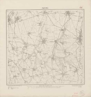
4415 (alte Nr.: 2510) Anröchte
Topographische Karte 4415 Anröchte
Topographische Karte 4415 Anröchte
Blatt 2510 Anröchte, neu: 4415
Blatt 2510 Anröchte, neu: 4415
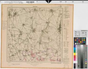
Katasteramt Arnsberg Kreis Arnsberg, Meßtischblatt Anröchte 4415, Farbige Einzeichnung mit Namensliste
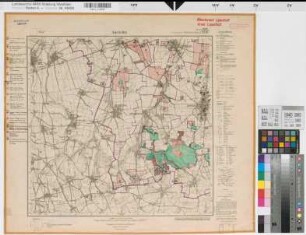
Katasteramt Lippstadt Kreis Lippstadt, Meßtischblatt Anröchte 4415, Farbige Einzeichnung mit Namensliste
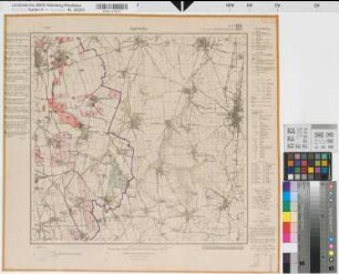
Katasteramt Soest Kreis Soest, Meßtischblatt Anröchte 4415, Farbige Einzeichnung mit Namensliste
Deutsche Grundkarte - Anröchte Nord (4415/12)
Deutsche Grundkarte - Anröchte Süd (4415/18)
4415 Anröchte
Blatt 4415 Anröchte
4415 (alte Nr.: 2510) Anröchte
Topographische Karte 4415 Anröchte
Topographische Karte 4415 Anröchte
Blatt 2510 Anröchte, neu: 4415
Blatt 2510 Anröchte, neu: 4415
Katasteramt Arnsberg Kreis Arnsberg, Meßtischblatt Anröchte 4415, Farbige Einzeichnung mit Namensliste
Katasteramt Lippstadt Kreis Lippstadt, Meßtischblatt Anröchte 4415, Farbige Einzeichnung mit Namensliste
Katasteramt Soest Kreis Soest, Meßtischblatt Anröchte 4415, Farbige Einzeichnung mit Namensliste
Deutsche Grundkarte - Anröchte Nord (4415/12)