Luftbildpläne
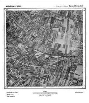
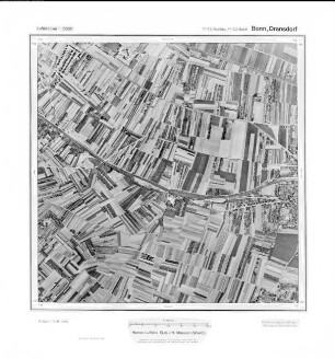
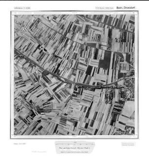
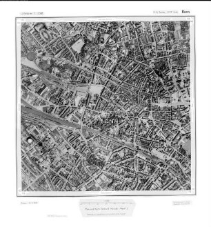
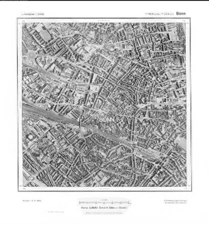
Bonn Dransdorf, Gauß-Krüger-Koordinaten: Rechtswert: 2572, Hochwert: 5622
- Dimensions
-
Maßstab: 1:10.000
- Further information
-
Land: NRW
- Context
-
Hansa Luftbild: Luftbildpläne 1:10.000 >> 2. Rechtswerte beginnend mit 25
- Holding
-
RW 0434 Hansa Luftbild: Luftbildpläne 1:10.000
- Creator
-
Hersteller: Hansa Luftbild
- Provenance
-
Hansa Luftbild
- Date of creation
-
1962
- Other object pages
- Delivered via
- Last update
-
24.06.2025, 2:17 PM CEST
Data provider
This object is provided by:
Landesarchiv Nordrhein-Westfalen. Abteilung Rheinland. If you have any questions about the object, please contact the data provider.
Landesarchiv Nordrhein-Westfalen. Abteilung Rheinland. If you have any questions about the object, please contact the data provider.
Object type
- Luftbildpläne
Associated
- Hersteller: Hansa Luftbild
- Hansa Luftbild
Time of origin
- 1962
Other Objects (12)
Bonn, Dransdorf, Gauß-Krüger-Koordinaten: Rechtswert: 2572, Hochwert: 5622

Bonn Dransdorf, Gauß-Krüger-Koordinaten: Rechtswert: 2572, Hochwert: 5622
Bonn Dransdorf, Gauß-Krüger-Koordinaten: Rechtswert: 2572, Hochwert: 5622
Bonn, Dransdorf, Gauß-Krüger-Koordinaten: Rechtswert: 2572, Hochwert: 5622
Bonn, Dransdorf, Gauß-Krüger-Koordinaten: Rechtswert: 2572, Hochwert: 5622
Bonn-Dransdorf, Problemsiedlung
St. Antonius Bonn-Dransdorf. Bücherverzeichnis
Beihilfe für Gutskapelle in Dransdorf, Kreis Bonn
Bonn, Gauß-Krüger-Koordinaten: Rechtswert: 2576, Hochwert: 5622
Bonn, Gauß-Krüger-Koordinaten: Rechtswert: 2576, Hochwert: 5622
Bonn, Gauß-Krüger-Koordinaten: Rechtswert: 2576, Hochwert: 5622
Bonn, Gauß-Krüger-Koordinaten: Rechtswert: 2576, Hochwert: 5622
Bonn, Dransdorf, Gauß-Krüger-Koordinaten: Rechtswert: 2572, Hochwert: 5622
Bonn Dransdorf, Gauß-Krüger-Koordinaten: Rechtswert: 2572, Hochwert: 5622
Bonn Dransdorf, Gauß-Krüger-Koordinaten: Rechtswert: 2572, Hochwert: 5622
Bonn, Dransdorf, Gauß-Krüger-Koordinaten: Rechtswert: 2572, Hochwert: 5622
Bonn, Dransdorf, Gauß-Krüger-Koordinaten: Rechtswert: 2572, Hochwert: 5622
Bonn-Dransdorf, Problemsiedlung
St. Antonius Bonn-Dransdorf. Bücherverzeichnis
Beihilfe für Gutskapelle in Dransdorf, Kreis Bonn
Bonn, Gauß-Krüger-Koordinaten: Rechtswert: 2576, Hochwert: 5622
Bonn, Gauß-Krüger-Koordinaten: Rechtswert: 2576, Hochwert: 5622
Bonn, Gauß-Krüger-Koordinaten: Rechtswert: 2576, Hochwert: 5622