Ämterkarte
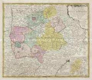
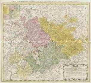
Tabula geographica sistens Territorium Liberae Sacri Romani Imperii Civitatis Suevo-Hallensis
- Alternative title
-
Tabula Geographica / sistens / TERRITORIUM / Liberae Sacri Romani Imperii
- Location
-
Deutsches Historisches Museum, Berlin
- Inventory number
-
Do 2006/412
- Measurements
-
Höhe x Breite: 57,8 x 66,7 cm (Blatt)
Höhe x Breite: 44,2 x 53,6 cm (Karte)
Höhe x Breite: 49,3 x 58,3 cm (Platte)
- Material/Technique
-
Druckfarbe, Papier, Kupferstich, koloriert
- Classification
-
Kartografie (Gattung)
- Subject (what)
-
Schwäbisch Hall
Hessen
- Event
-
Herstellung
- (who)
-
Kartograf: Matthaeus Ferdinand Cnopf
Verlag: Homannsche Erben
- (where)
-
Nürnberg, Deutschland
- (when)
-
1762
- Rights
-
Deutsches Historisches Museum
- Last update
-
24.03.2023, 9:31 AM CET
Data provider
This object is provided by:
Stiftung Deutsches Historisches Museum. If you have any questions about the object, please contact the data provider.
Stiftung Deutsches Historisches Museum. If you have any questions about the object, please contact the data provider.
Object type
- Ämterkarte
Associated
- Kartograf: Matthaeus Ferdinand Cnopf
- Verlag: Homannsche Erben
Time of origin
- 1762
Other Objects (12)
Mappa Geographica Territorii Sacri Romani Imperii liberae Civitatis Norimbergensis. Mit einer Nebenkarte: Districtus Criminalis Praefecturae Norimbergensis Lichtenau, sub eadem Scala Milliarium
Territorii Episcopatus Osnabrugensis Tabula geographica. Mit einer Nebenkarte: Ditio Reckenbergensis
![Karte des Amtes Leipzig, ca. 1:85 000, Kupferstich, nach 1755 : Praefectura Lipsiensis delineatione Geographica : Cum Priv. S. Reg. Maj. Pol. Elect. Sax. / ex observationibus accuratissimis descripta a Matth. Seutter. Geogr. Caesario Tob. Conr. Lotter sc.. - [Ca. 1:85 000]. - Augsburg : Tob. Conr. Lotter , [nach 1755]. - 1 Kt. auf 2 Bl. : Kupferst. ; 47 x 47 cm, Bildgr. 58 x 49 cm](https://iiif.deutsche-digitale-bibliothek.de/image/2/222cc07a-9b20-41d4-a795-0b120cc604c5/full/!306,450/0/default.jpg)
Karte des Amtes Leipzig, ca. 1:85 000, Kupferstich, nach 1755 : Praefectura Lipsiensis delineatione Geographica : Cum Priv. S. Reg. Maj. Pol. Elect. Sax. / ex observationibus accuratissimis descripta a Matth. Seutter. Geogr. Caesario Tob. Conr. Lotter sc.. - [Ca. 1:85 000]. - Augsburg : Tob. Conr. Lotter , [nach 1755]. - 1 Kt. auf 2 Bl. : Kupferst. ; 47 x 47 cm, Bildgr. 58 x 49 cm
![Karte der Ämter Wurzen, Eilenburg und Düben, ca. 1:110000, Kupferstich, um 1760 : Praefecturae Saxonicae Wurcensis, Eilenburgensis, Dubensis Geographica accuratione : secundum oppida, vicos, pagos, vicinias descriptae ; Cum Privileg. S. M. Pol. et Elect. Saxon. / à Matthaeo Seuttero S. C. M. Geogr. Tob. Conr. Lotter sc.. - [Ca. 1:110 000]. - Aug. Vindel. , [um 1760]. - 1 Kt. : Kupferst. ; 43 x 47 cm, Bildgr. 58 x 49 cm](https://iiif.deutsche-digitale-bibliothek.de/image/2/7d507cc0-fc51-406b-a6d9-7ffb73dcf50f/full/!306,450/0/default.jpg)
Karte der Ämter Wurzen, Eilenburg und Düben, ca. 1:110000, Kupferstich, um 1760 : Praefecturae Saxonicae Wurcensis, Eilenburgensis, Dubensis Geographica accuratione : secundum oppida, vicos, pagos, vicinias descriptae ; Cum Privileg. S. M. Pol. et Elect. Saxon. / à Matthaeo Seuttero S. C. M. Geogr. Tob. Conr. Lotter sc.. - [Ca. 1:110 000]. - Aug. Vindel. , [um 1760]. - 1 Kt. : Kupferst. ; 43 x 47 cm, Bildgr. 58 x 49 cm
![Karte vom Erzgebirgischen Kreis, 1:170 000, Kupferstich, nach 1739 : Mappa Geographica Circuli Metalliferi Electoratus Saxoniae cum omnibus, quae in eo comprehenduntur Praefecturis Et Dynastiis : quales sunt I. Praef. Zwickavienses, II. Praef. Schwarzenbergens. III. Dyn. Hartenstein, IV. Glaucha, V. Praef. Lemsa, VI. Praef. Waldenburg, VII Praef. Rochsburg, VIII. Praef. Penig, IX. Praef. Wechselburg, X. Praef. Chemnit, XI Praef. Stollberg, XII Praef. Grunhayn, XIII. Praef. Wolckenstain, XIV. Praef. Lauterstein, XV. Praef. Augustopolit. XVI. Praef. Franckenberg, XVII Praef. Nossen, XVIII Praef. Freyberg, XIX. Praef. Grullenburg, XX Praef. Frauenstein, XXI Praef. Altenberg, XXII Praef. Dippoldiswalda, Accedunt praefecturae circuli Misnici XXIII. Praef. Pirnensis cum Dyn. Lauenstein, XXIV. Praef. Loehmen, XXV. Praef. Hohenstein ; Cum Priv. S. M. Polon. et Elect. Saxon. / cura Matth. Seutter, Geogr. Caesar. Aug. Vind. Tob. Conr. Lotter sculpsit. - [Ca. 1:170 000]. - Aug. Vind. , [nach 1739]. - 1 Kt. auf 2 Bl. : Kupferst. ; Gesamtgr. 96 x 56 cm, je Teil 48 x 56 cm](https://iiif.deutsche-digitale-bibliothek.de/image/2/9d43eb1d-4b4a-4a2c-be87-c14b55858688/full/!306,450/0/default.jpg)
Karte vom Erzgebirgischen Kreis, 1:170 000, Kupferstich, nach 1739 : Mappa Geographica Circuli Metalliferi Electoratus Saxoniae cum omnibus, quae in eo comprehenduntur Praefecturis Et Dynastiis : quales sunt I. Praef. Zwickavienses, II. Praef. Schwarzenbergens. III. Dyn. Hartenstein, IV. Glaucha, V. Praef. Lemsa, VI. Praef. Waldenburg, VII Praef. Rochsburg, VIII. Praef. Penig, IX. Praef. Wechselburg, X. Praef. Chemnit, XI Praef. Stollberg, XII Praef. Grunhayn, XIII. Praef. Wolckenstain, XIV. Praef. Lauterstein, XV. Praef. Augustopolit. XVI. Praef. Franckenberg, XVII Praef. Nossen, XVIII Praef. Freyberg, XIX. Praef. Grullenburg, XX Praef. Frauenstein, XXI Praef. Altenberg, XXII Praef. Dippoldiswalda, Accedunt praefecturae circuli Misnici XXIII. Praef. Pirnensis cum Dyn. Lauenstein, XXIV. Praef. Loehmen, XXV. Praef. Hohenstein ; Cum Priv. S. M. Polon. et Elect. Saxon. / cura Matth. Seutter, Geogr. Caesar. Aug. Vind. Tob. Conr. Lotter sculpsit. - [Ca. 1:170 000]. - Aug. Vind. , [nach 1739]. - 1 Kt. auf 2 Bl. : Kupferst. ; Gesamtgr. 96 x 56 cm, je Teil 48 x 56 cm
Diocese u. Amt Dresden, 1:110 000, Kupferstich, 1757 : Seutter, Matthaeus: Diocese u. Amt Dresden, um 1757, ca. 1:110 000. Zeichner: (Adam Friedrich Zürner) 38,6 x 47,1 cm (Kupferstich, kol.)
Bauerkeller's Handatlas der allgemeinen Erdkunde, der Länder- und Staatenkunde: Die Britischen Inseln. Mit einer Nebenkarte: Shetlands-Inseln
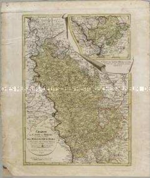
Geographische Abbildung des gantzen Umfangs der Marggrafschaft Meissen
Charte vom Laufe des Rheins von Coblenz bis Wesel. Mit einer Anschlusskarte: Charte den Lauf des Rheins von Coblenz bis Unkel... enthaltend
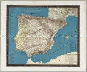
Bauerkeller's Handatlas der allgemeinen Erdkunde, der Länder- und Staatenkunde: Spanien und Portugal
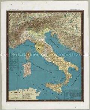
Bauerkeller's Handatlas der allgemeinen Erdkunde, der Länder- und Staatenkunde: Italien
![Karte der Ämter Rochlitz, Colditz und Leissnig, ca. 1:260 000, Kupferstich, 1759 : Haute-Saxe, Bailliage De Rochliz, Coldiz Et Leissnig. - [Ca. 1:260 000]. - [Paris] : [Le Rouge] , [1759]. - 1 Kt. : Kupferst. ; 27 x 20 cm](https://iiif.deutsche-digitale-bibliothek.de/image/2/6609d286-764b-4340-8df8-b0dee5a59688/full/!306,450/0/default.jpg)
Karte der Ämter Rochlitz, Colditz und Leissnig, ca. 1:260 000, Kupferstich, 1759 : Haute-Saxe, Bailliage De Rochliz, Coldiz Et Leissnig. - [Ca. 1:260 000]. - [Paris] : [Le Rouge] , [1759]. - 1 Kt. : Kupferst. ; 27 x 20 cm
Mappa Geographica Territorii Sacri Romani Imperii liberae Civitatis Norimbergensis. Mit einer Nebenkarte: Districtus Criminalis Praefecturae Norimbergensis Lichtenau, sub eadem Scala Milliarium
Territorii Episcopatus Osnabrugensis Tabula geographica. Mit einer Nebenkarte: Ditio Reckenbergensis
Karte des Amtes Leipzig, ca. 1:85 000, Kupferstich, nach 1755 : Praefectura Lipsiensis delineatione Geographica : Cum Priv. S. Reg. Maj. Pol. Elect. Sax. / ex observationibus accuratissimis descripta a Matth. Seutter. Geogr. Caesario Tob. Conr. Lotter sc.. - [Ca. 1:85 000]. - Augsburg : Tob. Conr. Lotter , [nach 1755]. - 1 Kt. auf 2 Bl. : Kupferst. ; 47 x 47 cm, Bildgr. 58 x 49 cm
Karte der Ämter Wurzen, Eilenburg und Düben, ca. 1:110000, Kupferstich, um 1760 : Praefecturae Saxonicae Wurcensis, Eilenburgensis, Dubensis Geographica accuratione : secundum oppida, vicos, pagos, vicinias descriptae ; Cum Privileg. S. M. Pol. et Elect. Saxon. / à Matthaeo Seuttero S. C. M. Geogr. Tob. Conr. Lotter sc.. - [Ca. 1:110 000]. - Aug. Vindel. , [um 1760]. - 1 Kt. : Kupferst. ; 43 x 47 cm, Bildgr. 58 x 49 cm
Karte vom Erzgebirgischen Kreis, 1:170 000, Kupferstich, nach 1739 : Mappa Geographica Circuli Metalliferi Electoratus Saxoniae cum omnibus, quae in eo comprehenduntur Praefecturis Et Dynastiis : quales sunt I. Praef. Zwickavienses, II. Praef. Schwarzenbergens. III. Dyn. Hartenstein, IV. Glaucha, V. Praef. Lemsa, VI. Praef. Waldenburg, VII Praef. Rochsburg, VIII. Praef. Penig, IX. Praef. Wechselburg, X. Praef. Chemnit, XI Praef. Stollberg, XII Praef. Grunhayn, XIII. Praef. Wolckenstain, XIV. Praef. Lauterstein, XV. Praef. Augustopolit. XVI. Praef. Franckenberg, XVII Praef. Nossen, XVIII Praef. Freyberg, XIX. Praef. Grullenburg, XX Praef. Frauenstein, XXI Praef. Altenberg, XXII Praef. Dippoldiswalda, Accedunt praefecturae circuli Misnici XXIII. Praef. Pirnensis cum Dyn. Lauenstein, XXIV. Praef. Loehmen, XXV. Praef. Hohenstein ; Cum Priv. S. M. Polon. et Elect. Saxon. / cura Matth. Seutter, Geogr. Caesar. Aug. Vind. Tob. Conr. Lotter sculpsit. - [Ca. 1:170 000]. - Aug. Vind. , [nach 1739]. - 1 Kt. auf 2 Bl. : Kupferst. ; Gesamtgr. 96 x 56 cm, je Teil 48 x 56 cm
Diocese u. Amt Dresden, 1:110 000, Kupferstich, 1757 : Seutter, Matthaeus: Diocese u. Amt Dresden, um 1757, ca. 1:110 000. Zeichner: (Adam Friedrich Zürner) 38,6 x 47,1 cm (Kupferstich, kol.)
Bauerkeller's Handatlas der allgemeinen Erdkunde, der Länder- und Staatenkunde: Die Britischen Inseln. Mit einer Nebenkarte: Shetlands-Inseln
Geographische Abbildung des gantzen Umfangs der Marggrafschaft Meissen
Charte vom Laufe des Rheins von Coblenz bis Wesel. Mit einer Anschlusskarte: Charte den Lauf des Rheins von Coblenz bis Unkel... enthaltend
Bauerkeller's Handatlas der allgemeinen Erdkunde, der Länder- und Staatenkunde: Spanien und Portugal
Bauerkeller's Handatlas der allgemeinen Erdkunde, der Länder- und Staatenkunde: Italien