Ämterkarte
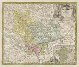
Mappa Geographica Territorii Sacri Romani Imperii liberae Civitatis Norimbergensis. Mit einer Nebenkarte: Districtus Criminalis Praefecturae Norimbergensis Lichtenau, sub eadem Scala Milliarium
- Alternative title
-
Mappa Geographica / TERRITORII / Sacri Romani Imperii liberae / CIVITATIS NORIMBERGENSIS.
- Location
-
Deutsches Historisches Museum, Berlin
- Inventory number
-
Do 2006/409
- Measurements
-
Höhe x Breite: 57 x 66,5 cm (Blatt)
Höhe x Breite: 46,2 x 54,2 cm (Karte)
Höhe x Breite: 49,2 x 57,3 cm (Platte)
- Material/Technique
-
Druckfarbe, Papier, Kupferstich, koloriert
- Classification
-
Kartografie (Gattung)
- Subject (what)
-
Nürnberg
- Event
-
Herstellung
- (who)
-
Kartograf: Matthaeus Ferdinand Cnopf
Stecher: Daniel Adam Hauer
Verlag: Homannsche Erben
- (where)
-
Nürnberg, Deutschland
- (when)
-
1764
- Rights
-
Deutsches Historisches Museum
- Last update
-
24.03.2023, 9:28 AM CET
Data provider
This object is provided by:
Stiftung Deutsches Historisches Museum. If you have any questions about the object, please contact the data provider.
Stiftung Deutsches Historisches Museum. If you have any questions about the object, please contact the data provider.
Object type
- Ämterkarte
Associated
- Kartograf: Matthaeus Ferdinand Cnopf
- Stecher: Daniel Adam Hauer
- Verlag: Homannsche Erben
Time of origin
- 1764
Other Objects (12)

Nova Territorii Erfordiensis
Praefecturae Principatus Querfurtensis Dahmiana Et Jüterboccensis
Chorographia Territorii Naumburgo-Citiensis
Chorographia Territorii Naumburgo-Citiensis
Nova Territorii Erfordien. Mit einer Ansicht: Die Stadt Erfurt
Territorii Episcopatus Osnabrugensis Tabula geographica. Mit einer Nebenkarte: Ditio Reckenbergensis
Delineatio Episcopatus Osnabrugensis. Mit einer Nebenkarte: Districtus Reckenbergensis und zwei Ansichten: Prospetus Palatii Osnabrug; Prospect der Stadt Osnabruck
Nova et accurata Territorii Ulmensis. Mit einer Nebenkarte: Grund und Abriß der Ulmischen Herrschaft zu Wain
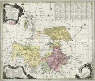
![Karte der Ämter Wurzen, Eilenburg und Düben, ca. 1:110000, Kupferstich, um 1760 : Praefecturae Saxonicae Wurcensis, Eilenburgensis, Dubensis Geographica accuratione : secundum oppida, vicos, pagos, vicinias descriptae ; Cum Privileg. S. M. Pol. et Elect. Saxon. / à Matthaeo Seuttero S. C. M. Geogr. Tob. Conr. Lotter sc.. - [Ca. 1:110 000]. - Aug. Vindel. , [um 1760]. - 1 Kt. : Kupferst. ; 43 x 47 cm, Bildgr. 58 x 49 cm](https://iiif.deutsche-digitale-bibliothek.de/image/2/7d507cc0-fc51-406b-a6d9-7ffb73dcf50f/full/!306,450/0/default.jpg)
Karte der Ämter Wurzen, Eilenburg und Düben, ca. 1:110000, Kupferstich, um 1760 : Praefecturae Saxonicae Wurcensis, Eilenburgensis, Dubensis Geographica accuratione : secundum oppida, vicos, pagos, vicinias descriptae ; Cum Privileg. S. M. Pol. et Elect. Saxon. / à Matthaeo Seuttero S. C. M. Geogr. Tob. Conr. Lotter sc.. - [Ca. 1:110 000]. - Aug. Vindel. , [um 1760]. - 1 Kt. : Kupferst. ; 43 x 47 cm, Bildgr. 58 x 49 cm
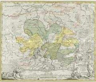
![Karte vom Erzgebirgischen Kreis, 1:170 000, Kupferstich, nach 1739 : Mappa Geographica Circuli Metalliferi Electoratus Saxoniae cum omnibus, quae in eo comprehenduntur Praefecturis Et Dynastiis : quales sunt I. Praef. Zwickavienses, II. Praef. Schwarzenbergens. III. Dyn. Hartenstein, IV. Glaucha, V. Praef. Lemsa, VI. Praef. Waldenburg, VII Praef. Rochsburg, VIII. Praef. Penig, IX. Praef. Wechselburg, X. Praef. Chemnit, XI Praef. Stollberg, XII Praef. Grunhayn, XIII. Praef. Wolckenstain, XIV. Praef. Lauterstein, XV. Praef. Augustopolit. XVI. Praef. Franckenberg, XVII Praef. Nossen, XVIII Praef. Freyberg, XIX. Praef. Grullenburg, XX Praef. Frauenstein, XXI Praef. Altenberg, XXII Praef. Dippoldiswalda, Accedunt praefecturae circuli Misnici XXIII. Praef. Pirnensis cum Dyn. Lauenstein, XXIV. Praef. Loehmen, XXV. Praef. Hohenstein ; Cum Priv. S. M. Polon. et Elect. Saxon. / cura Matth. Seutter, Geogr. Caesar. Aug. Vind. Tob. Conr. Lotter sculpsit. - [Ca. 1:170 000]. - Aug. Vind. , [nach 1739]. - 1 Kt. auf 2 Bl. : Kupferst. ; Gesamtgr. 96 x 56 cm, je Teil 48 x 56 cm](https://iiif.deutsche-digitale-bibliothek.de/image/2/9d43eb1d-4b4a-4a2c-be87-c14b55858688/full/!306,450/0/default.jpg)
Karte vom Erzgebirgischen Kreis, 1:170 000, Kupferstich, nach 1739 : Mappa Geographica Circuli Metalliferi Electoratus Saxoniae cum omnibus, quae in eo comprehenduntur Praefecturis Et Dynastiis : quales sunt I. Praef. Zwickavienses, II. Praef. Schwarzenbergens. III. Dyn. Hartenstein, IV. Glaucha, V. Praef. Lemsa, VI. Praef. Waldenburg, VII Praef. Rochsburg, VIII. Praef. Penig, IX. Praef. Wechselburg, X. Praef. Chemnit, XI Praef. Stollberg, XII Praef. Grunhayn, XIII. Praef. Wolckenstain, XIV. Praef. Lauterstein, XV. Praef. Augustopolit. XVI. Praef. Franckenberg, XVII Praef. Nossen, XVIII Praef. Freyberg, XIX. Praef. Grullenburg, XX Praef. Frauenstein, XXI Praef. Altenberg, XXII Praef. Dippoldiswalda, Accedunt praefecturae circuli Misnici XXIII. Praef. Pirnensis cum Dyn. Lauenstein, XXIV. Praef. Loehmen, XXV. Praef. Hohenstein ; Cum Priv. S. M. Polon. et Elect. Saxon. / cura Matth. Seutter, Geogr. Caesar. Aug. Vind. Tob. Conr. Lotter sculpsit. - [Ca. 1:170 000]. - Aug. Vind. , [nach 1739]. - 1 Kt. auf 2 Bl. : Kupferst. ; Gesamtgr. 96 x 56 cm, je Teil 48 x 56 cm
Diocese u. Amt Dresden, 1:110 000, Kupferstich, 1757 : Seutter, Matthaeus: Diocese u. Amt Dresden, um 1757, ca. 1:110 000. Zeichner: (Adam Friedrich Zürner) 38,6 x 47,1 cm (Kupferstich, kol.)
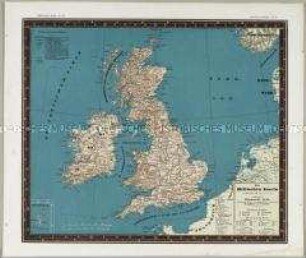
Bauerkeller's Handatlas der allgemeinen Erdkunde, der Länder- und Staatenkunde: Die Britischen Inseln. Mit einer Nebenkarte: Shetlands-Inseln
Nova Territorii Erfordiensis
Praefecturae Principatus Querfurtensis Dahmiana Et Jüterboccensis
Chorographia Territorii Naumburgo-Citiensis
Chorographia Territorii Naumburgo-Citiensis
Nova Territorii Erfordien. Mit einer Ansicht: Die Stadt Erfurt
Territorii Episcopatus Osnabrugensis Tabula geographica. Mit einer Nebenkarte: Ditio Reckenbergensis
Delineatio Episcopatus Osnabrugensis. Mit einer Nebenkarte: Districtus Reckenbergensis und zwei Ansichten: Prospetus Palatii Osnabrug; Prospect der Stadt Osnabruck
Nova et accurata Territorii Ulmensis. Mit einer Nebenkarte: Grund und Abriß der Ulmischen Herrschaft zu Wain
Karte der Ämter Wurzen, Eilenburg und Düben, ca. 1:110000, Kupferstich, um 1760 : Praefecturae Saxonicae Wurcensis, Eilenburgensis, Dubensis Geographica accuratione : secundum oppida, vicos, pagos, vicinias descriptae ; Cum Privileg. S. M. Pol. et Elect. Saxon. / à Matthaeo Seuttero S. C. M. Geogr. Tob. Conr. Lotter sc.. - [Ca. 1:110 000]. - Aug. Vindel. , [um 1760]. - 1 Kt. : Kupferst. ; 43 x 47 cm, Bildgr. 58 x 49 cm
Karte vom Erzgebirgischen Kreis, 1:170 000, Kupferstich, nach 1739 : Mappa Geographica Circuli Metalliferi Electoratus Saxoniae cum omnibus, quae in eo comprehenduntur Praefecturis Et Dynastiis : quales sunt I. Praef. Zwickavienses, II. Praef. Schwarzenbergens. III. Dyn. Hartenstein, IV. Glaucha, V. Praef. Lemsa, VI. Praef. Waldenburg, VII Praef. Rochsburg, VIII. Praef. Penig, IX. Praef. Wechselburg, X. Praef. Chemnit, XI Praef. Stollberg, XII Praef. Grunhayn, XIII. Praef. Wolckenstain, XIV. Praef. Lauterstein, XV. Praef. Augustopolit. XVI. Praef. Franckenberg, XVII Praef. Nossen, XVIII Praef. Freyberg, XIX. Praef. Grullenburg, XX Praef. Frauenstein, XXI Praef. Altenberg, XXII Praef. Dippoldiswalda, Accedunt praefecturae circuli Misnici XXIII. Praef. Pirnensis cum Dyn. Lauenstein, XXIV. Praef. Loehmen, XXV. Praef. Hohenstein ; Cum Priv. S. M. Polon. et Elect. Saxon. / cura Matth. Seutter, Geogr. Caesar. Aug. Vind. Tob. Conr. Lotter sculpsit. - [Ca. 1:170 000]. - Aug. Vind. , [nach 1739]. - 1 Kt. auf 2 Bl. : Kupferst. ; Gesamtgr. 96 x 56 cm, je Teil 48 x 56 cm
Diocese u. Amt Dresden, 1:110 000, Kupferstich, 1757 : Seutter, Matthaeus: Diocese u. Amt Dresden, um 1757, ca. 1:110 000. Zeichner: (Adam Friedrich Zürner) 38,6 x 47,1 cm (Kupferstich, kol.)