Altkarte
A New Map For Travelers Through the United States Of America : Showing the Railroads, Canals & Stage Roads ; With The Distances
- Weitere Titel
-
United States Of America
- Standort
-
München, Bayerische Staatsbibliothek -- Mapp. XXII,42 m#Kartenbeilage
- Maße
-
65 x 54 cm, gefaltet
- Umfang
-
1 Kt.
- Sprache
-
Englisch
- Anmerkungen
-
Lithographie
Nullmeridian: Washington. - Mit Ill. u. 5 Nebenkt.: Railroad & Canal Routes from Albany To Buffalo. Map Showing the Rail Roads between the Cities Of New York, Boston & Albany, and the Hudson R. from N. York to Albany. Rail Road Route From New York To Philadelphia. Rail Road Route from Philadelphia To Washington. Map Of Oregon, Northern California, Santa Fé &c. - Maßstab in graph. Form (Miles)
- Erschienen in
-
A new guide for travelers through the United States of America / containing all the railroad, stage, and steamboat routes, with the distances from place to place ; accompanied by a large and accurate map / by J. Calvin Smith ; Kartenbeilage
- Schlagwort
-
Schifffahrtskanal
Eisenbahn
Kalifornien
Oregon
USA
- Ereignis
-
Veröffentlichung
- (wo)
-
New York
- (wer)
-
Sherman & Smith
- (wann)
-
1848
- Beteiligte Personen und Organisationen
-
Smith, John Calvin
- URN
-
urn:nbn:de:bvb:12-bsb00046971-9
- Letzte Aktualisierung
-
16.04.2025, 08:51 MESZ
Datenpartner
Dieses Objekt wird bereitgestellt von:
Bayerische Staatsbibliothek. Bei Fragen zum Objekt wenden Sie sich bitte an den Datenpartner.
Bayerische Staatsbibliothek. Bei Fragen zum Objekt wenden Sie sich bitte an den Datenpartner.
Objekttyp
- Altkarte
Beteiligte
- Smith, John Calvin
- Sherman & Smith
Entstanden
- 1848
Ähnliche Objekte (12)
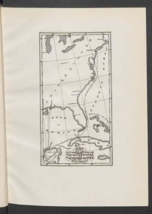
Map showing distances and routes from the United States to the ruined cities of Yucatan

Travelers

The Country and the Roads
The whispers of the muses : artworks as time travelers
across the veiled distances
The Roads of Empire.
Cotton-hauling The Roads
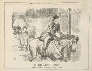
At the cross roads
Showing the way

EFFECT OF THE DISTANCES OF PUBLIC HEALTH FACILITIES FROM THE NEAREST MAJOR ROADS ON SKILLED DELIVERIES CONDUCTED IN KISUMU COUNTY, KENYA
On the center of distances

The Different Roads We Take
Map showing distances and routes from the United States to the ruined cities of Yucatan
Travelers
The Country and the Roads
The whispers of the muses : artworks as time travelers
across the veiled distances
The Roads of Empire.
Cotton-hauling The Roads
At the cross roads
Showing the way
EFFECT OF THE DISTANCES OF PUBLIC HEALTH FACILITIES FROM THE NEAREST MAJOR ROADS ON SKILLED DELIVERIES CONDUCTED IN KISUMU COUNTY, KENYA
On the center of distances