Druck
Hemisphaerii Borealis Coeli et Terrae Sphaeri casceno Graphia, Abbildung 25
Diapositiv aus Kunststoff in color, quer
- Standort
-
Sächsische Landesbibliothek - Staats- und Universitätsbibliothek Dresden (SLUB)
- Inventarnummer
-
Geogr.A.168
- Weitere Nummer(n)
-
df_ld_0020857 (Aufnahmenummer)
80763331 (Dokumentennummer)
- Material/Technik
-
Kunststoff (Fotografie)
- Verwandtes Objekt und Literatur
-
Repro aus: Cellarius, Andreas: Harmonia Macrocosmica Sev Atlas Universalis Et Novus, Totius Universi Creati Cosmographiam Generalem, Et Novam... Amstelodami: Joannes Janssonius, 1661
- Klassifikation
-
Druckgrafik (Gattung)
- Bezug (was)
-
Amsterdam
- Bezug (Ereignis)
-
Herstellung
- (wer)
-
Cellarius, Andreas (Hersteller)
Jansson, Jan (Kartograph)
- (Beschreibung)
-
Erschaffung abgebildetes Objekt
Kupferstich, koloriert; 426 x 492 mm (Material/Technik)
- Ereignis
-
Fotografische Aufnahme
- (wer)
-
Richter, Regine (Fotograf)
- (wann)
-
2004
- Rechteinformation
-
Bitte beachten Sie die Nutzungsbedingungen der Deutschen Fotothek.
- Letzte Aktualisierung
-
05.03.2025, 16:31 MEZ
Datenpartner
Dieses Objekt wird bereitgestellt von:
Deutsche Fotothek. Bei Fragen zum Objekt wenden Sie sich bitte an den Datenpartner.
Deutsche Fotothek. Bei Fragen zum Objekt wenden Sie sich bitte an den Datenpartner.
Objekttyp
- Druck
Beteiligte
- Richter, Regine (Fotograf)
- Cellarius, Andreas (Hersteller)
- Jansson, Jan (Kartograph)
Entstanden
- 2004
Ähnliche Objekte (12)
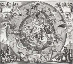
Hemisphaerii Borealis Coeli et Terrae Sphaeri casceno Graphia, Abbildung 25
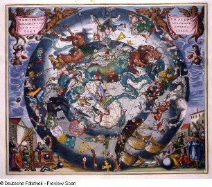
Haemisphaerium Scenographicum Australe Coeli Stellati et Terrae, Abbildung 28
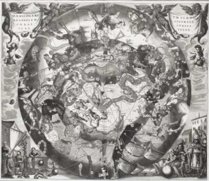
Haemisphaerium Scenographicum Australe Coeli Stellati et Terrae, Abbildung 28
![Karte der Großen Antillen, Kupferstich, um 1650 : Insularum Hispaniolae et Cubae : Cum Insulis circum jacentibus accurata delineatio / [herausgegeben von Joannes Janssonius]. - Circa 1:4 100 000. - [Amsterdam] : [Ioannes Ianssonius] , [1650]. - 1 Karte : Kupferstich ; 40 x 52 cm // Maßstab in graphischer Form (Milliaria Germanica, Leucae Hispanica). - Mit Titelkartusche und Maßstabskartusche. - Mit Kartennetz](https://iiif.deutsche-digitale-bibliothek.de/image/2/bc8a8807-01a0-402b-a759-0bb7b9add62f/full/!306,450/0/default.jpg)
Karte der Großen Antillen, Kupferstich, um 1650 : Insularum Hispaniolae et Cubae : Cum Insulis circum jacentibus accurata delineatio / [herausgegeben von Joannes Janssonius]. - Circa 1:4 100 000. - [Amsterdam] : [Ioannes Ianssonius] , [1650]. - 1 Karte : Kupferstich ; 40 x 52 cm // Maßstab in graphischer Form (Milliaria Germanica, Leucae Hispanica). - Mit Titelkartusche und Maßstabskartusche. - Mit Kartennetz
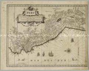
Peru
![Karte vom Territorium Bergamo, ca. 1:260 000, kolorierter Kupferstich, 1645 : Territorio Di Bergamo / Ioannes Ianssonius Excudit. - [Ca. 1:260.000]. - [Amsterdam] : Ioannes Ianssonius, [1645]. - 1 Kt : Kupferst ; 47 x 35 cm. - Maßstab in graph. Form (Milliaria Italica communia, Milliaria Germanica communia). - W oben](https://iiif.deutsche-digitale-bibliothek.de/image/2/de48b0b6-bb7e-4f21-b330-9a0722c10335/full/!306,450/0/default.jpg)
Karte vom Territorium Bergamo, ca. 1:260 000, kolorierter Kupferstich, 1645 : Territorio Di Bergamo / Ioannes Ianssonius Excudit. - [Ca. 1:260.000]. - [Amsterdam] : Ioannes Ianssonius, [1645]. - 1 Kt : Kupferst ; 47 x 35 cm. - Maßstab in graph. Form (Milliaria Italica communia, Milliaria Germanica communia). - W oben
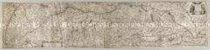
Maximi Totius Europae Fluminis Danubii Cursus Per Germaniam Hungariamque Nova Delineatio
![Karte der Republik Venedig, ca. 1:970 000, kolorierter Kupferstich, 1645 : Dominium Venetum In Italia : [gewidmet] Gulielmo Boreelio. - [Ca. 1:970.000]. - [Amsterdam] : Ioannes Ianssonius, [1645]. - 1 Kt : Kupferst ; 48 x 35 cm. - Maßstab in graph. Form (Milliaria Italica communia, Milliaria Germanica communia)](https://iiif.deutsche-digitale-bibliothek.de/image/2/1ced1e90-125f-4bc1-bce4-aed7a3c75680/full/!306,450/0/default.jpg)
Karte der Republik Venedig, ca. 1:970 000, kolorierter Kupferstich, 1645 : Dominium Venetum In Italia : [gewidmet] Gulielmo Boreelio. - [Ca. 1:970.000]. - [Amsterdam] : Ioannes Ianssonius, [1645]. - 1 Kt : Kupferst ; 48 x 35 cm. - Maßstab in graph. Form (Milliaria Italica communia, Milliaria Germanica communia)
![Seekarte vom Mittelmeer, Kupferstich, 1:4 200 000, 1656 : Pascaarte Van't westlyckste deel vande Middelandsche Zee : Vertonende in sich de ware gelegentheden van alle capen, havens, rivieren, bayen en droogte, zynde alles op zyn behoorlycke streckingen en distantien geleyt = Tabula Hydrographica de partibus Occidentalioribus Maris Mediterranei. - [Ca. 1:4 200 000] Amstelodami : Apud Ioan. Ianßonium : $aAmstelodami$bApud Ioan. Ianßonium$c[1656] , [1656]. - 1 Karte : Kupferstich ; 42 x 54 cm, Blattgröße 49 x 59 cm // Maßstab in graph. Form (Duytsche Mylen, Spaansche mylen)](https://iiif.deutsche-digitale-bibliothek.de/image/2/51d331d5-a4d6-49cb-9e5d-5a29c551a869/full/!306,450/0/default.jpg)
Seekarte vom Mittelmeer, Kupferstich, 1:4 200 000, 1656 : Pascaarte Van't westlyckste deel vande Middelandsche Zee : Vertonende in sich de ware gelegentheden van alle capen, havens, rivieren, bayen en droogte, zynde alles op zyn behoorlycke streckingen en distantien geleyt = Tabula Hydrographica de partibus Occidentalioribus Maris Mediterranei. - [Ca. 1:4 200 000] Amstelodami : Apud Ioan. Ianßonium : $aAmstelodami$bApud Ioan. Ianßonium$c[1656] , [1656]. - 1 Karte : Kupferstich ; 42 x 54 cm, Blattgröße 49 x 59 cm // Maßstab in graph. Form (Duytsche Mylen, Spaansche mylen)
![Stadtplan von Franeker, Niederlande , 1:1 800, kolorierter Kupferstich, um 1657 : Franekera - [Ca. 1.800] /[Amsterdam] : [Ioannes Ianssonius], [1657]. - 1 Vogelschaukarte : 1 Kupferst. ; 49,8 x 40,0 cm. - Mit 2 Wappen. - Mit Gebäudeverz. - Titel unten links. - Vermutl. aus: Theatrum Urbium Celebriorum totius Belgii Sive Germaniae Inferioris [Theatrum / 4] / Jansson, Jan. - Amstelodami//Amsterdam : Ioannes Ianssonius, 1657](https://iiif.deutsche-digitale-bibliothek.de/image/2/63183588-9759-4140-be8c-3b5fdaf6db66/full/!306,450/0/default.jpg)
Stadtplan von Franeker, Niederlande , 1:1 800, kolorierter Kupferstich, um 1657 : Franekera - [Ca. 1.800] /[Amsterdam] : [Ioannes Ianssonius], [1657]. - 1 Vogelschaukarte : 1 Kupferst. ; 49,8 x 40,0 cm. - Mit 2 Wappen. - Mit Gebäudeverz. - Titel unten links. - Vermutl. aus: Theatrum Urbium Celebriorum totius Belgii Sive Germaniae Inferioris [Theatrum / 4] / Jansson, Jan. - Amstelodami//Amsterdam : Ioannes Ianssonius, 1657
![Karte vom Territorium Mailand, ca. 1:290 000, kolorierter Kupferstich, 1645 : Ducato overo Territorio Di Milano. - [Ca. 1:290.000]. - [Amsterdam] : Ioannes Ianssonius, [1645]. - 1 Kt : Kupferst ; 46 x 35 cm. - Maßstab in graph. Form (Milliaria Italica communia, Milliaria Germanica communia)](https://iiif.deutsche-digitale-bibliothek.de/image/2/9e8e4579-076e-4248-b2fd-1ba93a341437/full/!306,450/0/default.jpg)
Karte vom Territorium Mailand, ca. 1:290 000, kolorierter Kupferstich, 1645 : Ducato overo Territorio Di Milano. - [Ca. 1:290.000]. - [Amsterdam] : Ioannes Ianssonius, [1645]. - 1 Kt : Kupferst ; 46 x 35 cm. - Maßstab in graph. Form (Milliaria Italica communia, Milliaria Germanica communia)
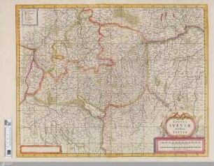
Totius Sueviae novissima Tabula
Hemisphaerii Borealis Coeli et Terrae Sphaeri casceno Graphia, Abbildung 25
Haemisphaerium Scenographicum Australe Coeli Stellati et Terrae, Abbildung 28
Haemisphaerium Scenographicum Australe Coeli Stellati et Terrae, Abbildung 28
Karte der Großen Antillen, Kupferstich, um 1650 : Insularum Hispaniolae et Cubae : Cum Insulis circum jacentibus accurata delineatio / [herausgegeben von Joannes Janssonius]. - Circa 1:4 100 000. - [Amsterdam] : [Ioannes Ianssonius] , [1650]. - 1 Karte : Kupferstich ; 40 x 52 cm // Maßstab in graphischer Form (Milliaria Germanica, Leucae Hispanica). - Mit Titelkartusche und Maßstabskartusche. - Mit Kartennetz
Peru
Karte vom Territorium Bergamo, ca. 1:260 000, kolorierter Kupferstich, 1645 : Territorio Di Bergamo / Ioannes Ianssonius Excudit. - [Ca. 1:260.000]. - [Amsterdam] : Ioannes Ianssonius, [1645]. - 1 Kt : Kupferst ; 47 x 35 cm. - Maßstab in graph. Form (Milliaria Italica communia, Milliaria Germanica communia). - W oben
Maximi Totius Europae Fluminis Danubii Cursus Per Germaniam Hungariamque Nova Delineatio
Karte der Republik Venedig, ca. 1:970 000, kolorierter Kupferstich, 1645 : Dominium Venetum In Italia : [gewidmet] Gulielmo Boreelio. - [Ca. 1:970.000]. - [Amsterdam] : Ioannes Ianssonius, [1645]. - 1 Kt : Kupferst ; 48 x 35 cm. - Maßstab in graph. Form (Milliaria Italica communia, Milliaria Germanica communia)
Seekarte vom Mittelmeer, Kupferstich, 1:4 200 000, 1656 : Pascaarte Van't westlyckste deel vande Middelandsche Zee : Vertonende in sich de ware gelegentheden van alle capen, havens, rivieren, bayen en droogte, zynde alles op zyn behoorlycke streckingen en distantien geleyt = Tabula Hydrographica de partibus Occidentalioribus Maris Mediterranei. - [Ca. 1:4 200 000] Amstelodami : Apud Ioan. Ianßonium : $aAmstelodami$bApud Ioan. Ianßonium$c[1656] , [1656]. - 1 Karte : Kupferstich ; 42 x 54 cm, Blattgröße 49 x 59 cm // Maßstab in graph. Form (Duytsche Mylen, Spaansche mylen)
Stadtplan von Franeker, Niederlande , 1:1 800, kolorierter Kupferstich, um 1657 : Franekera - [Ca. 1.800] /[Amsterdam] : [Ioannes Ianssonius], [1657]. - 1 Vogelschaukarte : 1 Kupferst. ; 49,8 x 40,0 cm. - Mit 2 Wappen. - Mit Gebäudeverz. - Titel unten links. - Vermutl. aus: Theatrum Urbium Celebriorum totius Belgii Sive Germaniae Inferioris [Theatrum / 4] / Jansson, Jan. - Amstelodami//Amsterdam : Ioannes Ianssonius, 1657
Karte vom Territorium Mailand, ca. 1:290 000, kolorierter Kupferstich, 1645 : Ducato overo Territorio Di Milano. - [Ca. 1:290.000]. - [Amsterdam] : Ioannes Ianssonius, [1645]. - 1 Kt : Kupferst ; 46 x 35 cm. - Maßstab in graph. Form (Milliaria Italica communia, Milliaria Germanica communia)