Verzeichnung
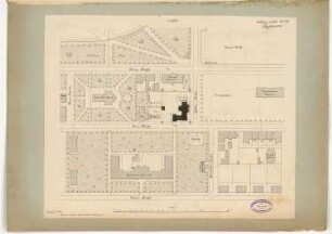
Lageplan Alte Torpedowerft Wilhelmshaven Maßstab: 1:1000 Hersteller: Marinewerft Wilhelmshaven
- Reference number
-
NLA OL, K-ZE, Best. 298 Z Nr. 4666
- Former reference number
-
Akz. 2010/057 Nr. 106
- Further information
-
Index-Gruppe: Institution: Marinewerft Wilhelmshaven
- Context
-
Zentraler Kartenbestand Oldenburg >> 5 Bezirksregierung Weser-Ems >> 5.15 Stadt Wilhelmshaven >> 5.15.10 Gewässer, Kanäle und Seekarten, Hafen- und Industrieanlagen
- Holding
-
NLA OL, K-ZE Zentraler Kartenbestand Oldenburg
- Indexentry place
-
Wilhelmshaven, Karte
- Former provenance
-
Landesamt für Küstenschutz
- Date of creation
-
08.11.1946
- Other object pages
- Last update
-
16.06.2025, 11:08 AM CEST
Data provider
This object is provided by:
Niedersächsisches Landesarchiv. If you have any questions about the object, please contact the data provider.
Niedersächsisches Landesarchiv. If you have any questions about the object, please contact the data provider.
Object type
- Verzeichnung
Associated
- Landesamt für Küstenschutz
Time of origin
- 08.11.1946
Other Objects (12)

Marinewerft Wilhelmshaven
Marinewerft Wilhelmshaven
Lüftungsbuch Panzerschiff "Admiral Scheer" (Marinewerft Wilhelmshaven)
Lüftungsbuch für den Kreuzer "Emden" (Marinewerft Wilhelmshaven)
Treibstoffversorgung der Kriegsmarine und der Marinewerft Wilhelmshaven
Lageplan der zu unterhaltenden Hafenflächen in Wilhelmshaven Maßstab: 1:5000 Hersteller: Marinewerft -Hafen- und Strombauressort- Wilhelmshaven
Aktenverzeichnis für Marinewerft Wilhelmshaven, Ausgabe 1908 (mit Nachträgen)
75 Jahre Marinewerft Wilhelmshaven : 1856 ; 25. Juni 1931
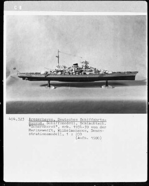
Schlachtschiff "Scharnhorst", erbaut 1934-1939 von der Marinewerft Wilhelmshaven, Demonstrationsmodell
Verlegung des Baggereiwerkes Tollerort wegen Übernahme durch die Marinewerft Wilhelmshaven
Verordnung für das Land Oldenburg, betr. Enteignung von Grundstücken zu Gunsten der Marinewerft Wilhelmshaven in Wilhelmshaven
Rathaus, Wilhelmshaven Monatskonkurrenz Februar 1890: Lageplan 1:1000
Marinewerft Wilhelmshaven
Marinewerft Wilhelmshaven
Lüftungsbuch Panzerschiff "Admiral Scheer" (Marinewerft Wilhelmshaven)
Lüftungsbuch für den Kreuzer "Emden" (Marinewerft Wilhelmshaven)
Treibstoffversorgung der Kriegsmarine und der Marinewerft Wilhelmshaven
Lageplan der zu unterhaltenden Hafenflächen in Wilhelmshaven Maßstab: 1:5000 Hersteller: Marinewerft -Hafen- und Strombauressort- Wilhelmshaven
Aktenverzeichnis für Marinewerft Wilhelmshaven, Ausgabe 1908 (mit Nachträgen)
75 Jahre Marinewerft Wilhelmshaven : 1856 ; 25. Juni 1931
Schlachtschiff "Scharnhorst", erbaut 1934-1939 von der Marinewerft Wilhelmshaven, Demonstrationsmodell
Verlegung des Baggereiwerkes Tollerort wegen Übernahme durch die Marinewerft Wilhelmshaven
Verordnung für das Land Oldenburg, betr. Enteignung von Grundstücken zu Gunsten der Marinewerft Wilhelmshaven in Wilhelmshaven