- Alternative title
-
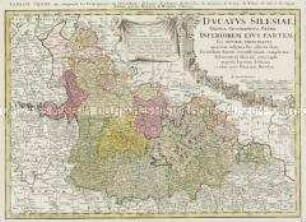
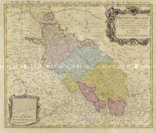
PRINCIPATVS SILESIAE/ GROTKANI/ exactissima Tabula geographica / exhibens/ TERRAM NISSENSEM simul ac Circulos/ GROTKAU, OTTMUCHAU, et ZIEGENHALS/ à/ I.W. Wieland diligentissime delineata ob praematuram mortem / Authoris denuo rectificata per Caesareum Locumtenent: et/ Archit: militarem MATTHAEU[M] a SCHUBARTH/ ac sumptibus Principum et Ord: Silesiae.A.O.R. MDCCXXXVI./ excusa Norimbergae/ ab HAEREDIBUS HOMANNIANIS:/ Cum spec. S. CAES.RG: MAI: Priv.
- Location
-
Deutsches Historisches Museum, Berlin
- Inventory number
-
Do 2002/182
- Measurements
-
Höhe x Breite: 60,6 x 93 cm (Blatt), Höhe x Breite: 58,8 x 85,4 cm (Platte)
- Material/Technique
-
Papier, Kupferstich, koloriert
- Classification
-
Kartografie (Gattung)
- Subject (what)
-
Schlesien
- Event
-
Herstellung
- (who)
-
Kartograf: Johann Wolfgang Wieland
Kartograf: Matthäus von Schubarth
Verlag: Homannsche Erben
- (where)
-
Nürnberg [historisch: Norimbergae], Deutschland [historisch: Heiliges Römisches Reich]
- (when)
-
1736
- Rights
-
Deutsches Historisches Museum
- Last update
-
24.03.2023, 9:30 AM CET
Data provider
This object is provided by:
Stiftung Deutsches Historisches Museum. If you have any questions about the object, please contact the data provider.
Stiftung Deutsches Historisches Museum. If you have any questions about the object, please contact the data provider.
Object type
- Regionalkarte
Associated
- Kartograf: Johann Wolfgang Wieland
- Kartograf: Matthäus von Schubarth
- Verlag: Homannsche Erben
Time of origin
- 1736
Other Objects (12)

Principatus Silesiae Oelsnensis
Principatus Silesiae Oppaviensis
Principatus Silesiae Saganensis
Principatus Silesiae Munsterbergensis
Principatus Silesiae Wolani
Principatus Silesiae Saganensis
Principatus Silesiae Glogoviensis
Principatus Silesiae Bregensis
Principatus Silesiae Grotkani
Principatus Silesiae Lignicensis
Ducatus Silesiae Tabula Geographica Prima Inferiorem eius Partem seu Nova Principatus
Ducatus Silesiae
Principatus Silesiae Oelsnensis
Principatus Silesiae Oppaviensis
Principatus Silesiae Saganensis
Principatus Silesiae Munsterbergensis
Principatus Silesiae Wolani
Principatus Silesiae Saganensis
Principatus Silesiae Glogoviensis
Principatus Silesiae Bregensis
Principatus Silesiae Grotkani
Principatus Silesiae Lignicensis
Ducatus Silesiae Tabula Geographica Prima Inferiorem eius Partem seu Nova Principatus