Karte / Plan
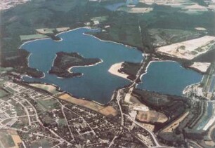
Lippe: Karte der Lippe von Wesel bis Haltern (Flusskilometer 0 bis 48)
- Former reference number
-
Lippe-Verband (Dep.)
- Dimensions
-
Höhe: 36 cm, Breite: 310 cm, Maßstab: 1:15000
- Further information
-
Ort: Lippe
- Context
-
Karten A (Allgemein) >> 3. Gewässer >> 3.1. Gewässer / Wasserbau >> 3.1.3. Lippe
- Holding
-
W 051 Karten A (Allgemein)
- Indexentry place
-
Lippe
- Date of creation
-
o. D.
- Other object pages
- Provenance
-
Sammlungsregistraturbildner
- Delivered via
- Last update
-
17.09.2025, 3:02 PM CEST
Data provider
This object is provided by:
Landesarchiv Nordrhein-Westfalen. Abteilung Westfalen. If you have any questions about the object, please contact the data provider.
Landesarchiv Nordrhein-Westfalen. Abteilung Westfalen. If you have any questions about the object, please contact the data provider.
Object type
- Karten / Pläne
Time of origin
- o. D.
Other Objects (12)

Kanal Wesel-Datteln. Kanalisierung der Lippe vom Rhein bis Haltern. Lippe-Seitenkanal von Haltern bis zum Dortmund-Ems-Kanal, Anlage 9 (Erläuterungsbericht)
Kanal Wesel-Datteln. Kanalisierung der Lippe vom Rhein bis Haltern. Lippe-Seitenkanal von Haltern bis zum Dortmund-Ems-Kanal, Anlage 10 (Übersichtslageplan 1:25.000)

Lippe: Karte der Lippe von Haltern bis Datteln(Flusskilometer 49 bis 63)
Stevetalsperre Haltern, Versickerungsbecken Lippe
Kanalisierung der Lippe von Lippstadt bis Wesel
Blutige Lippe : Kriminalgeschichten von Bad Lippspringe bis Wesel
Blutige Lippe 4 : Kriminalgeschichten von Lippstadt bis Wesel
Projektierung der Lippe-Seitenkanäle von Wesel bis Datteln

Lippe: Lippemündung bei Wesel
Lippe Kanalisierung (Wesel-Lippstadt)
Blutige Lippe 2 : Kriminalgeschichten von Bad Lippspringe bis Wesel

Lippe: Katasterkarte Umgebung Lippe (Flusskilometer 126-130) Gemarkung Haltern Kirchspiel, Gemarkung Haltern Stadt, Gemarkung Hamm
Kanal Wesel-Datteln. Kanalisierung der Lippe vom Rhein bis Haltern. Lippe-Seitenkanal von Haltern bis zum Dortmund-Ems-Kanal, Anlage 9 (Erläuterungsbericht)
Kanal Wesel-Datteln. Kanalisierung der Lippe vom Rhein bis Haltern. Lippe-Seitenkanal von Haltern bis zum Dortmund-Ems-Kanal, Anlage 10 (Übersichtslageplan 1:25.000)
Lippe: Karte der Lippe von Haltern bis Datteln(Flusskilometer 49 bis 63)
Stevetalsperre Haltern, Versickerungsbecken Lippe
Kanalisierung der Lippe von Lippstadt bis Wesel
Blutige Lippe : Kriminalgeschichten von Bad Lippspringe bis Wesel
Blutige Lippe 4 : Kriminalgeschichten von Lippstadt bis Wesel
Projektierung der Lippe-Seitenkanäle von Wesel bis Datteln
Lippe: Lippemündung bei Wesel
Lippe Kanalisierung (Wesel-Lippstadt)
Blutige Lippe 2 : Kriminalgeschichten von Bad Lippspringe bis Wesel