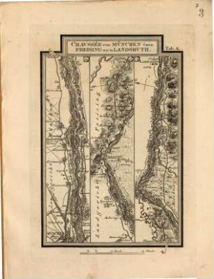
Topographischer Atlas vom Königreiche Baiern diesseits des Rhein, [60]. Dillingen
- Location
-
München, Bayerische Staatsbibliothek -- Mapp. XI,57 du-60
- Dimensions
-
50 x 79 cm
- Extent
-
1 Karte
- Language
-
Deutsch
- Notes
-
schwarz-weiß
Maßstab in graphischer Form (Eine Chaussée Meile zu 25406 baier. Fuss) Mitte unten
- Bibliographic citation
-
Topographischer Atlas vom Königreiche Baiern diesseits des Rhein ; 60
- Event
-
Veröffentlichung
- (where)
-
[München]
- (who)
-
[Topographisches Bureau]
- (when)
-
[1831?]
- Contributor
- URN
-
urn:nbn:de:bvb:12-bsb00011196-5
- Last update
-
16.04.2025, 8:31 AM CEST
Data provider
This object is provided by:
Bayerische Staatsbibliothek. If you have any questions about the object, please contact the data provider.
Bayerische Staatsbibliothek. If you have any questions about the object, please contact the data provider.
Associated
- Rickauer, Max von
- Schwarzmann
- Naus, Joseph
- Riedl, Adrian von
- Schmidt, August
- [Topographisches Bureau]
Time of origin
- [1831?]
Other Objects (12)
Fortsetzung des Adrian von Riedlschen Reise-Atlas vom Königreiche Bayern, 1
Fortsetzung des Adrian von Riedlschen Reise-Atlas vom Königreiche Bayern, 2
Fortsetzung des Adrian von Riedlschen Reise-Atlas vom Königreiche Bayern, 2
Fortsetzung des Adrian von Riedlschen Reise-Atlas vom Königreiche Bayern, 1
Verbesserte Auflage des Adrian von Riedlschen Reise-Atlas vom Königreiche Bayern, 1
Verbesserte Auflage des Adrian von Riedlschen Reise-Atlas vom Königreiche Bayern, 1
Verbesserte Auflage des Adrian von Riedlschen Reise-Atlas vom Königreiche Bayern, 2
Verbesserte Auflage des Adrian von Riedlschen Reise-Atlas vom Königreiche Bayern, 2
Prof. Dr. G. Werner's Spiegeldreikant (A. Schmidt)
Untersuchungen über zwei neuere Erdbeben, das schweizerische vom 7. Januar 1889 und das nordamerikanische vom 31. August 1886
![Wellen und Gezeiten des Festlandes [Bd. 53, 1897]](https://iiif.deutsche-digitale-bibliothek.de/image/2/ccf936db-129d-4aaf-b40e-ed27b033442e/full/!306,450/0/default.jpg)
Wellen und Gezeiten des Festlandes [Bd. 53, 1897]
Wellenbewegug und Erdbeben. Ein Beitrag zur Dynamik der Erdbeben
Fortsetzung des Adrian von Riedlschen Reise-Atlas vom Königreiche Bayern, 1
Fortsetzung des Adrian von Riedlschen Reise-Atlas vom Königreiche Bayern, 2
Fortsetzung des Adrian von Riedlschen Reise-Atlas vom Königreiche Bayern, 2
Fortsetzung des Adrian von Riedlschen Reise-Atlas vom Königreiche Bayern, 1
Verbesserte Auflage des Adrian von Riedlschen Reise-Atlas vom Königreiche Bayern, 1
Verbesserte Auflage des Adrian von Riedlschen Reise-Atlas vom Königreiche Bayern, 1
Verbesserte Auflage des Adrian von Riedlschen Reise-Atlas vom Königreiche Bayern, 2
Verbesserte Auflage des Adrian von Riedlschen Reise-Atlas vom Königreiche Bayern, 2
Prof. Dr. G. Werner's Spiegeldreikant (A. Schmidt)
Untersuchungen über zwei neuere Erdbeben, das schweizerische vom 7. Januar 1889 und das nordamerikanische vom 31. August 1886
Wellen und Gezeiten des Festlandes [Bd. 53, 1897]