- Reference number
-
WHK 43/13
- Dimensions
-
380x230 mm; 390x210 mm; 470x230 mm; 450x250 mm
- Further information
-
Identifikation (Karte/Plan): Inhaltliche Beschreibung: Blatt 1 = Berechnungen der Flugbahnen zur Bombardierung von Zielen, um 1770
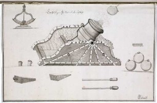
Identifikation (Karte/Plan): Inhaltliche Beschreibung: Blatt 2 = Kanone, Mörser und Petarde
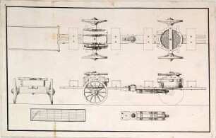
Identifikation (Karte/Plan): Inhaltliche Beschreibung: Blatt 3 = Haubitze mit Lafette, um 1770
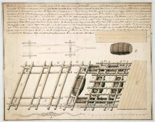
Identifikation (Karte/Plan): Inhaltliche Beschreibung: Blatt 4 = Mörser auf dem Stuhl, 1770
Weitere Angaben (Karte/Plan): Maßstab: Maßstab nicht ausgeführt
Weitere Angaben (Karte/Plan): Ausführung: Handschrift
Weitere Angaben (Karte/Plan): Blattzahl: 4
- Context
-
Wilhelmshöher Kriegskarten >> Revüen und Manöver >> WHK 43 Pläne der Artillerie
- Holding
-
WHK Wilhelmshöher Kriegskarten
- Creator
-
Bach; Cancrinus (cop.)
- Former provenance
-
Wilhelmshöher Kriegskarten
- Date of creation
-
1770
- Other object pages
- Last update
-
10.06.2025, 9:13 AM CEST
Data provider
This object is provided by:
Hessisches Staatsarchiv Marburg. If you have any questions about the object, please contact the data provider.
Hessisches Staatsarchiv Marburg. If you have any questions about the object, please contact the data provider.
Object type
- Karte/Plan
Associated
- Bach; Cancrinus (cop.)
- Wilhelmshöher Kriegskarten
Time of origin
- 1770
Other Objects (12)
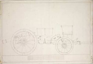
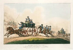
WHK 43 Pläne der Artillerie: 'Fahrende Artillerie'
WHK 43 Pläne der Artillerie: 'Fahrende Artillerie'
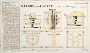
WHK 43 Pläne der Artillerie: Hublafette
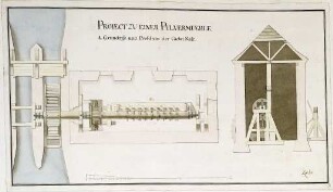
WHK 43 Pläne der Artillerie: Pulvermühle
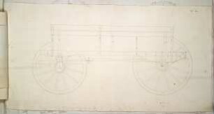
WHK 43 Pläne der Artillerie: Munitionswagen
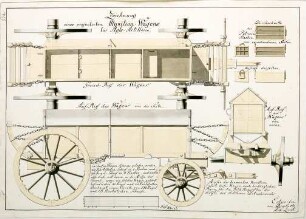
WHK 43 Pläne der Artillerie: Geplanter Munitionswagen für die Artillerie
WHK 44 Manöver der Artillerie: Abbildung der 'fliegenden Artillerie', 1798

WHK 43 Pläne der Artillerie: Index zu "Pläne der Artillerie"
WHK 44 Manöver der Artillerie: Index zu "Manöver der Artillerie"
WHK 43 Pläne der Artillerie: Verschiedene Mörser
WHK 43 Pläne der Artillerie: Fassbrücke, 1737
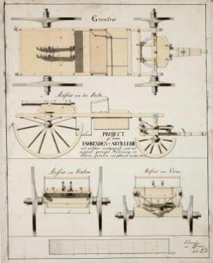
WHK 43 Pläne der Artillerie: Fahrbare Kanonen
WHK 43 Pläne der Artillerie: 'Fahrende Artillerie'
WHK 43 Pläne der Artillerie: 'Fahrende Artillerie'
WHK 43 Pläne der Artillerie: Hublafette
WHK 43 Pläne der Artillerie: Pulvermühle
WHK 43 Pläne der Artillerie: Munitionswagen
WHK 43 Pläne der Artillerie: Geplanter Munitionswagen für die Artillerie
WHK 44 Manöver der Artillerie: Abbildung der 'fliegenden Artillerie', 1798
WHK 43 Pläne der Artillerie: Index zu "Pläne der Artillerie"
WHK 44 Manöver der Artillerie: Index zu "Manöver der Artillerie"
WHK 43 Pläne der Artillerie: Verschiedene Mörser
WHK 43 Pläne der Artillerie: Fassbrücke, 1737