- Alternative title
-
Deutsches Reich mit der politischen Einteilung
- Location
-
München, Bayerische Staatsbibliothek -- Mapp. VIII,95 y
- Dimensions
-
131 x 100 cm, gefaltet
- Extent
-
1 Kt.
- Language
-
Deutsch
- Notes
-
mehrfarb.
Mit 2 Nebenkt. - Kartengrundlage: Gea-Verkehrskarte - Deutsches Reich 1:1000000
- Keyword
-
Verwaltungsgrenze
Deutschland
- Event
-
Veröffentlichung
- (where)
-
Berlin
- (who)
-
Gea-Verl.
- (when)
-
s.a. [1940]
- URN
-
urn:nbn:de:bvb:12-bsb00021809-3
- Last update
-
16.04.2025, 8:48 AM CEST
Data provider
This object is provided by:
Bayerische Staatsbibliothek. If you have any questions about the object, please contact the data provider.
Bayerische Staatsbibliothek. If you have any questions about the object, please contact the data provider.
Object type
- Karte
Associated
- Gea-Verl.
Time of origin
- s.a. [1940]
Other Objects (12)

Gea-Übersichtskarte Deutsches Reich mit politischen und kirchlichen Einteilungen.
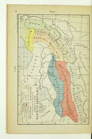
Einteilung der Alpen
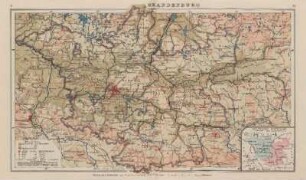
Brandenburg, Politische Einteilung
![[Bodenverhältnisse und politische Einteilung.]](https://iiif.deutsche-digitale-bibliothek.de/image/2/f4330e1f-3b35-415d-a070-5db73777390a/full/!306,450/0/default.jpg)
[Bodenverhältnisse und politische Einteilung.]
![[Bodenverhältnisse und politische Einteilung.]](https://iiif.deutsche-digitale-bibliothek.de/image/2/7cfad755-2b6a-4e4e-ab06-85db718ee753/full/!306,450/0/default.jpg)
[Bodenverhältnisse und politische Einteilung.]
![[Bodenverhältnisse und politische Einteilung.]](https://iiif.deutsche-digitale-bibliothek.de/image/2/70216763-db6d-4f16-90bf-62787f64b961/full/!306,450/0/default.jpg)
[Bodenverhältnisse und politische Einteilung.]
![[Bodenverhältnisse und politische Einteilung.]](https://iiif.deutsche-digitale-bibliothek.de/image/2/fdc0b92e-921c-4c3e-96f4-e3eae7e812aa/full/!306,450/0/default.jpg)
[Bodenverhältnisse und politische Einteilung.]
![[Bodenverhältnisse und politische Einteilung.]](https://iiif.deutsche-digitale-bibliothek.de/image/2/25e3c278-e09b-4b53-b495-e8f8dbe7385e/full/!306,450/0/default.jpg)
[Bodenverhältnisse und politische Einteilung.]
![[Übersichtskarte]](https://iiif.deutsche-digitale-bibliothek.de/image/2/36060665-10d2-44e1-9d56-568dd1efb035/full/!306,450/0/default.jpg)
[Übersichtskarte]
![[Übersichtskarte]](https://iiif.deutsche-digitale-bibliothek.de/image/2/fd3bdbd3-ec5f-4a9a-8aef-fde186e384e2/full/!306,450/0/default.jpg)
[Übersichtskarte]

Übersichtskarte
![[Übersichtskarte]](https://iiif.deutsche-digitale-bibliothek.de/image/2/d7c25640-00e0-4d73-9c02-744ea4ae9b36/full/!306,450/0/default.jpg)
[Übersichtskarte]
Gea-Übersichtskarte Deutsches Reich mit politischen und kirchlichen Einteilungen.
Einteilung der Alpen
Brandenburg, Politische Einteilung
[Bodenverhältnisse und politische Einteilung.]
[Bodenverhältnisse und politische Einteilung.]
[Bodenverhältnisse und politische Einteilung.]
[Bodenverhältnisse und politische Einteilung.]
[Bodenverhältnisse und politische Einteilung.]
[Übersichtskarte]
[Übersichtskarte]
Übersichtskarte
[Übersichtskarte]
Gea-Übersichtskarte Deutsches Reich mit politischen und kirchlichen Einteilungen.
Einteilung der Alpen
Brandenburg, Politische Einteilung
[Bodenverhältnisse und politische Einteilung.]
[Bodenverhältnisse und politische Einteilung.]
[Bodenverhältnisse und politische Einteilung.]
[Bodenverhältnisse und politische Einteilung.]
[Bodenverhältnisse und politische Einteilung.]
[Übersichtskarte]
[Übersichtskarte]
Übersichtskarte