Geomorphologische Kartographie in der Bundesrepublik Deutschland: Normung und Weiterentwicklung
Abstract: After a short recapitulation of the essentials of geomorphological mapping a critical analysis of the cartographic concept of a modern geomorphological map of the Federal Republic of Germany (“Geomorphologische Karte der Bundesrepublik Deutschland - GMK) is given. In this context the presentation of morphographic details, especially slope curvature, is discussed. In principal, a dual-sheet system of geomorphological mapping is required. Following the proposal of Hagedorn & Lehmeier (1983), and completing their morphogenetic version, a corresponding morphographic mapping method is presented. Its aim is to connect the effect of plastic shading with detailed morphometric description. Contours and selected topographic elements serve as the map base. As general form characteristics the slope categories of inclination and vertical curvature are displayed by raster screens, combining grey tone values and different raster types. In addition, slope discontinuities and special form elements .... https://www.erdkunde.uni-bonn.de/article/view/2174
- Location
-
Deutsche Nationalbibliothek Frankfurt am Main
- Extent
-
Online-Ressource
- Language
-
Englisch
- Bibliographic citation
-
Geomorphologische Kartographie in der Bundesrepublik Deutschland: Normung und Weiterentwicklung ; volume:43 ; number:2 ; year:1989
Erdkunde ; 43, Heft 2 (1989)
- Creator
-
Spönemann, Jürgen
Lehmeier, Friedmut
- DOI
-
10.3112/erdkunde.1989.02.01
- URN
-
urn:nbn:de:101:1-2410290903062.485879371733
- Rights
-
Open Access; Der Zugriff auf das Objekt ist unbeschränkt möglich.
- Last update
-
15.08.2025, 7:34 AM CEST
Data provider
Deutsche Nationalbibliothek. If you have any questions about the object, please contact the data provider.
Associated
- Spönemann, Jürgen
- Lehmeier, Friedmut
Other Objects (12)

Geomorphologische Kartographie

Symposium der Kommissionen für Hangforschung und geomorphologische Kartographie in Belgien 1966
Topographische Kartographie, [...]. Normung bei topographischen Karten / G. Martschin
Geomorphologische Probleme
Geomorphologische Skizze
Geomorphologische Strukturen

Probleme Geomorphologische
Geomorphologische Strukturen
Geomorphologische Detailaufnahme
Geomorphologische Karte der Bundesrepublik Deutschland, Blatt 8313: Wehr
Geomorphologische Karte der Bundesrepublik Deutschland, Blatt 3: 6417 Mannheim-Nordost
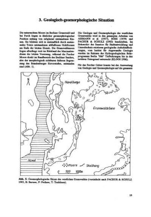
3. Geologisch-geomorphologische Situation
Geomorphologische Kartographie
Symposium der Kommissionen für Hangforschung und geomorphologische Kartographie in Belgien 1966
Topographische Kartographie, [...]. Normung bei topographischen Karten / G. Martschin
Geomorphologische Probleme
Geomorphologische Skizze
Geomorphologische Strukturen
Probleme Geomorphologische
Geomorphologische Strukturen
Geomorphologische Detailaufnahme
Geomorphologische Karte der Bundesrepublik Deutschland, Blatt 8313: Wehr
Geomorphologische Karte der Bundesrepublik Deutschland, Blatt 3: 6417 Mannheim-Nordost