Karten / Pläne
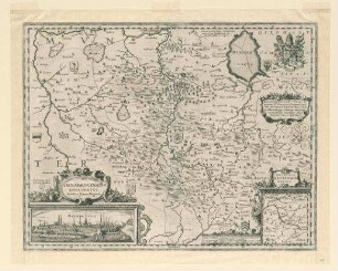
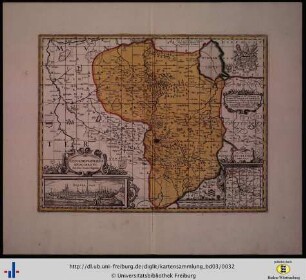
Münster (Bistum) Osnabrück (Bistum) Territorialkarte Episcopatum Monasteriensis et Osnabrugensis ... novissima et accurata delineatio 1.H. 18.Jh. 5 dt. Meilen = 9,2 cm 55 x 47,5 farb. Kupferstich: Matthäus Seutter, Augsburg Tobias Conrad Lotter sculp. B I Nr. 15
- Former reference number
-
B I 15
- Further information
-
Ort: Bistum Münster
- Context
-
Karten A (Allgemein) >> 1. Topographische Karte, Übersichtskarten >> 1.3. Territorialkarten
- Holding
-
W 051 Karten A (Allgemein)
- Indexentry place
-
Bistum Münster
Münster, Bistum, Territorialkarte, 1725
Osnabrück, Bistum, Territorialkarte s. Münster, 1725
- Provenance
-
Sammlungsregistraturbildner
- Date of creation
-
1725
- Other object pages
- Delivered via
- Last update
-
24.06.2025, 2:11 PM CEST
Data provider
This object is provided by:
Landesarchiv Nordrhein-Westfalen. Abteilung Westfalen. If you have any questions about the object, please contact the data provider.
Landesarchiv Nordrhein-Westfalen. Abteilung Westfalen. If you have any questions about the object, please contact the data provider.
Object type
- Karten / Pläne
Associated
- Sammlungsregistraturbildner
Time of origin
- 1725
Other Objects (12)
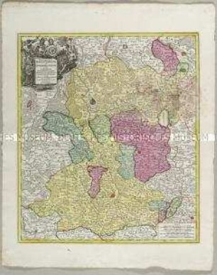
Episcopatum Monasteriensis et Osnabrugensis
![Notificationes et congratulationes ad episcopatum Ratibonensem [Bistum Regensburg]](https://iiif.deutsche-digitale-bibliothek.de/image/2/a6a288ed-6c28-456d-8be6-cebce2f989b9/full/!306,450/0/default.jpg)
Notificationes et congratulationes ad episcopatum Ratibonensem [Bistum Regensburg]
Paderborn (Bistum) Territorialkarte 18.Jh. 3 dt. Meilen = 9,5 cm 47,5 x 53 farb. Stich: Matthaeus Seutter, Augsburg Tob. Con. Lotter sc. Bem.: Stadtansicht
Münster (Bistum) Osnabrück (Bistum) Territorialkarte Episcopatus Monasteriensis et Osnabrugensis nec non comitatuum Bentheim, Tecklenburg, Stenford, Lingen, Diepholt, Delmenhorst, Rietberg etc tabula 17. Jh. 6 dt. Meilen = 9,25 cm 55,5 x 47 Druck: I. Danckerts, Amsterdam Landsberg-Velen Nr. 718
Registrum feudorum episcopatum Halberstadensis

Bistum
Bistümer
Osnabrugensis Epicopatus nova delineatio (Karte vom Bistum Osnabrück) Vermesser/Zeichner: Georg Wilhelm von Busche/Franc Christian Benoit
Erzbistum Mainz, Bistum Worms und Bistum Speyer
Registerband Jahrbuch Bistum Limburg (Limburger Bistums-Kalender)
Osnabrugensis episopatus
Osnabrugensis episcopatus
Episcopatum Monasteriensis et Osnabrugensis
Notificationes et congratulationes ad episcopatum Ratibonensem [Bistum Regensburg]
Paderborn (Bistum) Territorialkarte 18.Jh. 3 dt. Meilen = 9,5 cm 47,5 x 53 farb. Stich: Matthaeus Seutter, Augsburg Tob. Con. Lotter sc. Bem.: Stadtansicht
Münster (Bistum) Osnabrück (Bistum) Territorialkarte Episcopatus Monasteriensis et Osnabrugensis nec non comitatuum Bentheim, Tecklenburg, Stenford, Lingen, Diepholt, Delmenhorst, Rietberg etc tabula 17. Jh. 6 dt. Meilen = 9,25 cm 55,5 x 47 Druck: I. Danckerts, Amsterdam Landsberg-Velen Nr. 718
Registrum feudorum episcopatum Halberstadensis
Bistum
Bistümer
Osnabrugensis Epicopatus nova delineatio (Karte vom Bistum Osnabrück) Vermesser/Zeichner: Georg Wilhelm von Busche/Franc Christian Benoit
Erzbistum Mainz, Bistum Worms und Bistum Speyer
Registerband Jahrbuch Bistum Limburg (Limburger Bistums-Kalender)
Osnabrugensis episopatus