Karten und Pläne
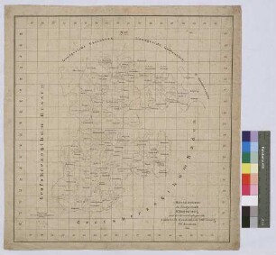
Übersichtskarte des Amtsgerichtes Miltenberg
Enthält: Zwölf gelb bzw. grün markierte Flächen
- Reference number
-
Landesarchiv Baden-Württemberg, Abt. Staatsarchiv Wertheim, R-K Nr. 3208
- Dimensions
-
60x 60 (Höhe x Breite)
- Notes
-
Stempel des Messungsamtes Klingenberg
- Further information
-
Ausführung: Druck
- Context
-
Karten und Pläne >> C. Bayern >> C.27. Miltenberg
- Holding
-
Landesarchiv Baden-Württemberg, Abt. Staatsarchiv Wertheim, R-K Karten und Pläne
- Creator
-
Autor/Fotograf: L.Lertahelly, Hrsg. v. Bayer. Landesvermessungsamt
- Date of creation
-
1935/40
- Other object pages
- Rights
-
Es gelten die Nutzungsbedingungen des Landesarchivs Baden-Württemberg.
- Last update
-
26.03.2024, 9:03 AM CET
Data provider
This object is provided by:
Landesarchiv Baden-Württemberg. If you have any questions about the object, please contact the data provider.
Landesarchiv Baden-Württemberg. If you have any questions about the object, please contact the data provider.
Object type
- Karten und Pläne
Associated
- Autor/Fotograf: L.Lertahelly, Hrsg. v. Bayer. Landesvermessungsamt
Time of origin
- 1935/40
Other Objects (12)

Übersichtskarte des Amtsgerichtes Miltenberg
Übersichtskarte des Amtsgerichtes Miltenberg
Übersichtskarte des Amtsgerichtes Trostberg im Jahre 1879
Übersichtskarte der Amtsgerichte Amorbach, Klingenberg und Miltenberg
Miltenberg
Übersichtskarte des Landgerichts Klingenberg und der Herrschaftsgerichte Amorbach, Kleinheubach, Miltenberg, Wildenstein (Inselkarte)
Gemarkung Miltenberg
Krippenschau Miltenberg
Gemarkung Miltenberg
Steuergemeinde Miltenberg
Gemarkung Miltenberg: Bodenbenutzungserhebung
Eisenbahnlinie Miltenberg- Wertheim
Übersichtskarte des Amtsgerichtes Miltenberg
Übersichtskarte des Amtsgerichtes Miltenberg
Übersichtskarte des Amtsgerichtes Trostberg im Jahre 1879
Übersichtskarte der Amtsgerichte Amorbach, Klingenberg und Miltenberg
Miltenberg
Übersichtskarte des Landgerichts Klingenberg und der Herrschaftsgerichte Amorbach, Kleinheubach, Miltenberg, Wildenstein (Inselkarte)
Gemarkung Miltenberg
Krippenschau Miltenberg
Gemarkung Miltenberg
Steuergemeinde Miltenberg
Gemarkung Miltenberg: Bodenbenutzungserhebung