- Standort
-
München, Bayerische Staatsbibliothek -- Mapp. II,185
- Maße
-
52 x 35 cm
- Umfang
-
1 Kt.
- Ausgabe
-
Stand vom Juni 1942
- Sprache
-
Deutsch
- Anmerkungen
-
mehrfarb.
Mit 1 Nebenkt.: Rheinisch-westfälisches Industriegebiet
- Schlagwort
-
Deutschland
Mitteleuropa
- Ereignis
-
Veröffentlichung
- (wo)
-
Prag ; Brünn
- (wer)
-
Zentral-Lehrer-Verlag u. Buchhandel
- (wann)
-
1942
- Beteiligte Personen und Organisationen
- URN
-
urn:nbn:de:bvb:12-bsb00002995-8
- Letzte Aktualisierung
-
27.11.2025, 08:49 MEZ
Datenpartner
Dieses Objekt wird bereitgestellt von:
Bayerische Staatsbibliothek. Bei Fragen zum Objekt wenden Sie sich bitte an den Datenpartner.
Bayerische Staatsbibliothek. Bei Fragen zum Objekt wenden Sie sich bitte an den Datenpartner.
Objekttyp
- Karte
Beteiligte
- Štůla, Frantisek (Sonstige)
- Semík, Matěj (Sonstige)
- Leixner, Frantisek (Sonstige)
- Zentral-Lehrer-Verlag u. Buchhandel
Entstanden
- 1942
Ähnliche Objekte (12)

Übersichtskarte des Großdeutschen Reiches : in 5 Farben

Übersichtskarte (Kreis Fulda u. angrenzende Gebiete.)

Eisenbahnkarte: Rhön und deren angrenzende Gebiete.
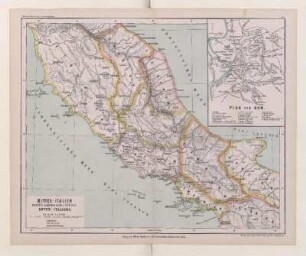
Mittel-Italien und die angrenzenden Gebiete Unter-Italiens

Politische Karte der Österreichisch-Ungarischen Monarchie nebst angrenzenden Gebieten
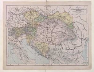
Politische Karte der Österreichisch-Ungarischen Monarchie nebst angrenzenden Gebieten

Höhenschichten-Karte von Elsass-Lothringen und den angrenzenden Gebieten

Die Abtei Wadgassen und die angrenzenden Gebiete im Jahre 1789

Karte des Spalter Bezirks und Kreises, der Nebenlagen und des angrenzenden Gebietes

Hopfenbau-Karte des Aisch- und Zenngrundes, ihrer Nebenlagen und des angrenzenden Gebietes
![[Nr. 19-24: Karten des engeren mitteldeutschen Industriebezirks und der angrenzenden Gebiete]](https://iiif.deutsche-digitale-bibliothek.de/image/2/fb1eac9a-e06c-49c7-9343-871f9929b501/full/!306,450/0/default.jpg)
[Nr. 19-24: Karten des engeren mitteldeutschen Industriebezirks und der angrenzenden Gebiete]

Italien und die angrenzenden Theile des römischen Reichs
Übersichtskarte des Großdeutschen Reiches : in 5 Farben
Übersichtskarte (Kreis Fulda u. angrenzende Gebiete.)
Eisenbahnkarte: Rhön und deren angrenzende Gebiete.
Mittel-Italien und die angrenzenden Gebiete Unter-Italiens
Politische Karte der Österreichisch-Ungarischen Monarchie nebst angrenzenden Gebieten
Politische Karte der Österreichisch-Ungarischen Monarchie nebst angrenzenden Gebieten
Höhenschichten-Karte von Elsass-Lothringen und den angrenzenden Gebieten
Die Abtei Wadgassen und die angrenzenden Gebiete im Jahre 1789
Karte des Spalter Bezirks und Kreises, der Nebenlagen und des angrenzenden Gebietes
Hopfenbau-Karte des Aisch- und Zenngrundes, ihrer Nebenlagen und des angrenzenden Gebietes
[Nr. 19-24: Karten des engeren mitteldeutschen Industriebezirks und der angrenzenden Gebiete]