Karten / Pläne
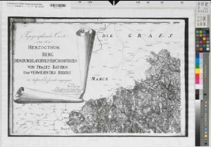
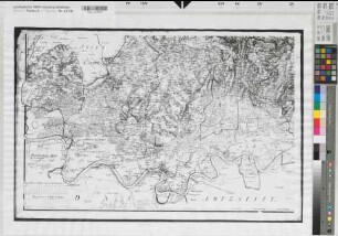
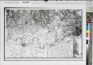
Berg (Herzogtum) topographische Karte von dem Herzogtum Berg in 4 Teilen 1789-1792 1 : 50 000 47 x 74, Original 96 x 62 Foto nach Kupferstich Carl Friedrich Wiebeking, kurpfälzischer Wasserbaumeister Originale in Staatsbibliothek Berlin N 32581
- Former reference number
-
Staatsbiblioth. Berlin N 32581
- Further information
-
Ort: Herzogtum Berg
- Context
-
Karten A (Allgemein) >> 1. Topographische Karte, Übersichtskarten >> 1.1. Geographische, topographische Karten
- Holding
-
W 051 Karten A (Allgemein)
- Indexentry place
-
Herzogtum Berg
Berg, Herzogtum, topographische Karte, 1792
- Provenance
-
Sammlungsregistraturbildner
- Date of creation
-
1792
- Other object pages
- Delivered via
- Last update
-
24.06.2025, 1:23 PM CEST
Data provider
This object is provided by:
Landesarchiv Nordrhein-Westfalen. Abteilung Westfalen. If you have any questions about the object, please contact the data provider.
Landesarchiv Nordrhein-Westfalen. Abteilung Westfalen. If you have any questions about the object, please contact the data provider.
Object type
- Karten / Pläne
Associated
- Sammlungsregistraturbildner
Time of origin
- 1792
Other Objects (12)

Wasserbaumeister Wiebeking
Wasserbaumeister Wiebeking
Berg (Herzogtum) topographische Karte von dem Herzogtum Berg in 4 Teilen 1789-1792 1 : 50 000 47 x 74, Original 96 x 62 Foto nach Kupferstich Carl Friedrich Wiebeking, kurpfälzischer Wasserbaumeister Originale in Staatsbibliothek Berlin N 32581
Berg (Herzogtum) topographische Karte von dem Herzogtum Berg in 4 Teilen 1789-1792 1 : 50 000 47 x 74, Original 96 x 62 Foto nach Kupferstich Carl Friedrich Wiebeking, kupfälzischer Wasserbaumeister Originale in Staatsbibliothek Berlin N 32581
Berg (Herzogtum) topographische Karte von dem Herzogtum Berg in 4 Teilen 1789-1792 1 : 50 000 47 x 74, Original 96 x 62 Foto nach Kupferstich Carl Friedrich Wiebeking, kurpfälzischer Wasserbaumeister Originale in Staatsbibliothek Berlin N 32581
Kaufmann Wilh. Franz Camphausen : Ankauf der Wasserburg, bisheriger Besitzer Wasserbaumeister Wiebeking
![Herzogtum Berg, Wiebeking- Karte (Teil): Carte des Herzogthums Berg [in 4 Teilen]. dem Durchlauchtigsten Churfürsten von Pfaltz Bayern und Verweser des Reichs in tiefster Ehrfurcht zugeeignet: von Wiebeking Churpfältzischer Waßerbaumeister [Teil 1] Gestochen von Eckard [Teil 4] Paul Maassen scul. 1790 [Teil 1]](https://iiif.deutsche-digitale-bibliothek.de/image/2/b5a4de91-28d7-41d5-b54a-69b1a751245b/full/!306,450/0/default.jpg)
Herzogtum Berg, Wiebeking- Karte (Teil): Carte des Herzogthums Berg [in 4 Teilen]. dem Durchlauchtigsten Churfürsten von Pfaltz Bayern und Verweser des Reichs in tiefster Ehrfurcht zugeeignet: von Wiebeking Churpfältzischer Waßerbaumeister [Teil 1] Gestochen von Eckard [Teil 4] Paul Maassen scul. 1790 [Teil 1]
Herzogtum Berg
Jülich-Berg: Herzogtum
2.5.3. Herzogtum Berg
5.21.2.2.2. Herzogtum Berg
2.9.1.3. Herzogtum Berg
Wasserbaumeister Wiebeking
Wasserbaumeister Wiebeking
Berg (Herzogtum) topographische Karte von dem Herzogtum Berg in 4 Teilen 1789-1792 1 : 50 000 47 x 74, Original 96 x 62 Foto nach Kupferstich Carl Friedrich Wiebeking, kurpfälzischer Wasserbaumeister Originale in Staatsbibliothek Berlin N 32581
Berg (Herzogtum) topographische Karte von dem Herzogtum Berg in 4 Teilen 1789-1792 1 : 50 000 47 x 74, Original 96 x 62 Foto nach Kupferstich Carl Friedrich Wiebeking, kupfälzischer Wasserbaumeister Originale in Staatsbibliothek Berlin N 32581
Berg (Herzogtum) topographische Karte von dem Herzogtum Berg in 4 Teilen 1789-1792 1 : 50 000 47 x 74, Original 96 x 62 Foto nach Kupferstich Carl Friedrich Wiebeking, kurpfälzischer Wasserbaumeister Originale in Staatsbibliothek Berlin N 32581
Kaufmann Wilh. Franz Camphausen : Ankauf der Wasserburg, bisheriger Besitzer Wasserbaumeister Wiebeking
Herzogtum Berg, Wiebeking- Karte (Teil): Carte des Herzogthums Berg [in 4 Teilen]. dem Durchlauchtigsten Churfürsten von Pfaltz Bayern und Verweser des Reichs in tiefster Ehrfurcht zugeeignet: von Wiebeking Churpfältzischer Waßerbaumeister [Teil 1] Gestochen von Eckard [Teil 4] Paul Maassen scul. 1790 [Teil 1]
Herzogtum Berg
Jülich-Berg: Herzogtum
2.5.3. Herzogtum Berg
5.21.2.2.2. Herzogtum Berg