Karte/Plan
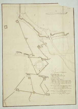
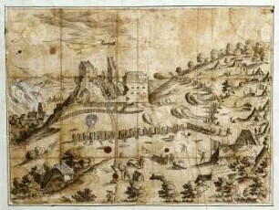
WHK 1 Einzelne kriegerische Vorfälle: Belagerung von Cartagena durch die englische Flotte
- Reference number
-
WHK 1/60
- Dimensions
-
578 x 485 mm
- Further information
-
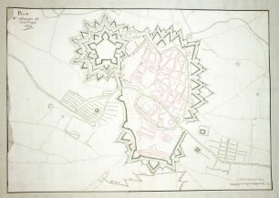
Identifikation (Karte/Plan): Originaltitel: This Plan of the Harbour, Town and Several Forts of Cartagena. In which is Exhibited a Perfect View of the English Fleet as they Ancored all along the Coast, in the Bay, near the Town; and also after they moved and laid under the Forts oft St. Jago uand St. Philipe, and at the Boca-chica or Mouth of the Harbour: Likewise of the English Ships as they moved in different parts in the Harbour, on order to lay Siege to the Town.
Weitere Angaben (Karte/Plan): Maßstab: 3 Furlongs = 11,6 cm [1:40.000]
Weitere Angaben (Karte/Plan): Ausführung: Handzeichnung, farbig
Weitere Angaben (Karte/Plan): Blattzahl: 1
- Context
-
Wilhelmshöher Kriegskarten >> Einzelne Kriege und Schlachtordnungen >> WHK 1 Einzelne kriegerische Vorfälle
- Holding
-
WHK Wilhelmshöher Kriegskarten
- Creator
-
T. Kohlhardt
- Date of creation
-
[1770-1790]
- Other object pages
- Last update
-
10.06.2025, 9:13 AM CEST
Data provider
This object is provided by:
Hessisches Staatsarchiv Marburg. If you have any questions about the object, please contact the data provider.
Hessisches Staatsarchiv Marburg. If you have any questions about the object, please contact the data provider.
Object type
- Karte/Plan
Associated
- T. Kohlhardt
Time of origin
- [1770-1790]
Other Objects (12)

WHK 1 Einzelne kriegerische Vorfälle: Belagerung von Cartagena durch die englische Flotte
WHK 1 Einzelne kriegerische Vorfälle: Index zu "Einzelne kriegerische Vorfälle"
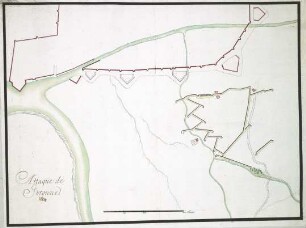
WHK 1 Einzelne kriegerische Vorfälle: Angriff von Courtrai
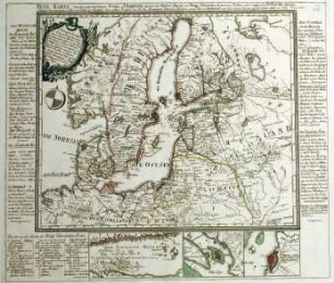
WHK 1 Einzelne kriegerische Vorfälle: Kriegsschauplätze zwischen den russischen und schwedischen Armeen und Flotten, 1788
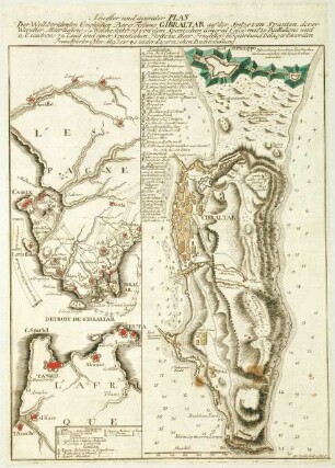
WHK 1 Einzelne kriegerische Vorfälle: Belagerung von Gibraltar, 1779
WHK 1 Einzelne kriegerische Vorfälle: Belagerung von Braunschweig, 1671
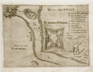
WHK 1 Einzelne kriegerische Vorfälle: Schlacht um Rügen, 1678
WHK 1 Einzelne kriegerische Vorfälle: Angriff auf Gerona, 1684
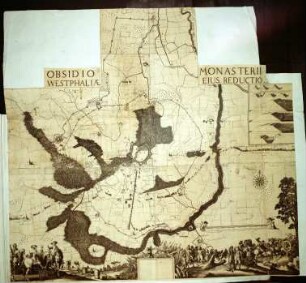
WHK 1 Einzelne kriegerische Vorfälle: Belagerung von Münster, 1661
WHK 1 Einzelne kriegerische Vorfälle: Belagerung von Landstuhl, 1523
WHK 1 Einzelne kriegerische Vorfälle: Belagerung von Luxemburg, 1684
WHK 1 Einzelne kriegerische Vorfälle: Belagerung von Guilliers, 1610
WHK 1 Einzelne kriegerische Vorfälle: Belagerung von Cartagena durch die englische Flotte
WHK 1 Einzelne kriegerische Vorfälle: Index zu "Einzelne kriegerische Vorfälle"
WHK 1 Einzelne kriegerische Vorfälle: Angriff von Courtrai
WHK 1 Einzelne kriegerische Vorfälle: Kriegsschauplätze zwischen den russischen und schwedischen Armeen und Flotten, 1788
WHK 1 Einzelne kriegerische Vorfälle: Belagerung von Gibraltar, 1779
WHK 1 Einzelne kriegerische Vorfälle: Belagerung von Braunschweig, 1671
WHK 1 Einzelne kriegerische Vorfälle: Schlacht um Rügen, 1678
WHK 1 Einzelne kriegerische Vorfälle: Angriff auf Gerona, 1684
WHK 1 Einzelne kriegerische Vorfälle: Belagerung von Münster, 1661
WHK 1 Einzelne kriegerische Vorfälle: Belagerung von Landstuhl, 1523
WHK 1 Einzelne kriegerische Vorfälle: Belagerung von Luxemburg, 1684