Karten / Pläne
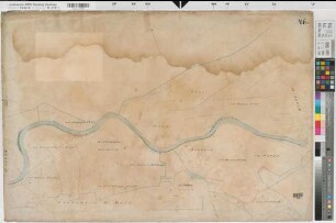
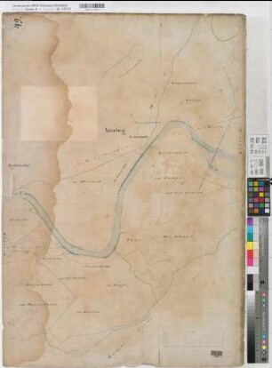
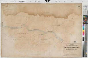
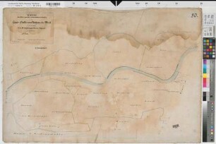
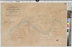
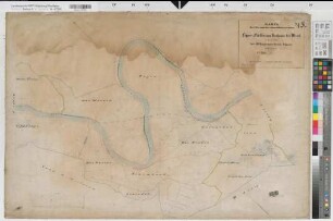
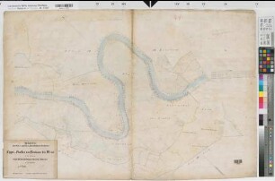
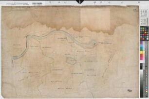
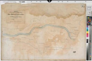
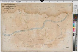
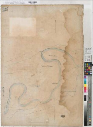
Lippe: Karte der Ufer und des Inundations-Gebietes des Lippe-Flusses von Neuhaus bis Wesel in III Sectionen. Section III: Regierungs-Bezirk Münster in 22 Blättern (14. Blatt)
- Reference number
-
W 051, 47612
- Former reference number
-
Lippe-Verband (Dep.) B.V.1.53.
- Dimensions
-
Höhe: 67 cm, Breite: 98,5 cm, Maßstab: 1:2500
- Notes
-
vorangehendes 13. Blatt lag nicht zur Verzeichnung vor (Okt. 2009)
- Further information
-
Ort: Lippe
- Context
-
Karten A (Allgemein) >> 3. Gewässer >> 3.1. Gewässer / Wasserbau >> 3.1.3. Lippe
- Holding
-
W 051 Karten A (Allgemein)
- Indexentry place
-
Lippe
- Provenance
-
Sammlungsregistraturbildner
- Date of creation
-
1858-1859
- Other object pages
- Delivered via
- Last update
-
30.04.2025, 2:33 PM CEST
Data provider
This object is provided by:
Landesarchiv Nordrhein-Westfalen. Abteilung Westfalen. If you have any questions about the object, please contact the data provider.
Landesarchiv Nordrhein-Westfalen. Abteilung Westfalen. If you have any questions about the object, please contact the data provider.
Object type
- Karten / Pläne
Associated
- Sammlungsregistraturbildner
Time of origin
- 1858-1859
Other Objects (12)
Lippe: Karte der Ufer und des Inundations-Gebietes des Lippe-Flusses von Neuhaus bis Wesel in III Sectionen. Section III: Regierungs-Bezirk Münster in 22 Blättern (12. Blatt)
Lippe: Karte der Ufer und des Inundations-Gebietes des Lippe-Flusses von Neuhaus bis Wesel in III Sectionen. Section III: Regierungs-Bezirk Münster in 22 Blättern (15. Blatt)
Lippe: Karte der Ufer und des Inundations-Gebietes des Lippe-Flusses von Neuhaus bis Wesel in III Sectionen. Section III: Regierungs-Bezirk Münster in 22 Blättern (10. Blatt)
Lippe: Karte der Ufer und des Inundations-Gebietes des Lippe-Flusses von Neuhaus bis Wesel in III Sectionen. Section III: Regierungs-Bezirk Münster in 22 Blättern (16. Blatt)
Lippe: Karte der Ufer und des Inundations-Gebietes des Lippe-Flusses von Neuhaus bis Wesel in III Sectionen. Section III: Regierungs-Bezirk Münster in 22 Blättern (22. Blatt)
Lippe: Karte der Ufer und des Inundations-Gebietes des Lippe-Flusses von Neuhaus bis Wesel in III Sectionen. Section III: Regierungs-Bezirk Münster in 22 Blättern (9. Blatt)
Lippe: Karte der Ufer und des Inundations-Gebietes des Lippe-Flusses von Neuhaus bis Wesel in III Sectionen. Section III: Regierungs-Bezirk Münster in 22 Blättern (9. Blatt)
Lippe: Karte der Ufer und des Inundations-Gebietes des Lippe-Flusses von Neuhaus bis Wesel in III Sectionen. Section III: Regierungs-Bezirk Münster in 22 Blättern (8. Blatt)

Lippe: Karte der Ufer und des Inundations-Gebietes des Lippe-Flusses von Neuhaus bis Wesel in III Sectionen. Section III: Regierungs-Bezirk Münster in 22 Blättern (20. Blatt)
Lippe: Karte der Ufer und des Inundations-Gebietes des Lippe-Flusses von Neuhaus bis Wesel in III Sectionen. Section III: Regierungs-Bezirk Münster in 22 Blättern (19. Blatt)
Lippe: Karte der Ufer und des Inundations-Gebietes des Lippe-Flusses von Neuhaus bis Wesel in III Sectionen. Section III: Regierungs-Bezirk Münster in 22 Blättern (17. Blatt)
Lippe: Karte der Ufer und des Inundations-Gebietes des Lippe-Flusses von Neuhaus bis Wesel in III Sectionen. Section III: Regierungs-Bezirk Münster in 22 Blättern (11. Blatt)
Lippe: Karte der Ufer und des Inundations-Gebietes des Lippe-Flusses von Neuhaus bis Wesel in III Sectionen. Section III: Regierungs-Bezirk Münster in 22 Blättern (12. Blatt)
Lippe: Karte der Ufer und des Inundations-Gebietes des Lippe-Flusses von Neuhaus bis Wesel in III Sectionen. Section III: Regierungs-Bezirk Münster in 22 Blättern (15. Blatt)
Lippe: Karte der Ufer und des Inundations-Gebietes des Lippe-Flusses von Neuhaus bis Wesel in III Sectionen. Section III: Regierungs-Bezirk Münster in 22 Blättern (10. Blatt)
Lippe: Karte der Ufer und des Inundations-Gebietes des Lippe-Flusses von Neuhaus bis Wesel in III Sectionen. Section III: Regierungs-Bezirk Münster in 22 Blättern (16. Blatt)
Lippe: Karte der Ufer und des Inundations-Gebietes des Lippe-Flusses von Neuhaus bis Wesel in III Sectionen. Section III: Regierungs-Bezirk Münster in 22 Blättern (22. Blatt)
Lippe: Karte der Ufer und des Inundations-Gebietes des Lippe-Flusses von Neuhaus bis Wesel in III Sectionen. Section III: Regierungs-Bezirk Münster in 22 Blättern (9. Blatt)
Lippe: Karte der Ufer und des Inundations-Gebietes des Lippe-Flusses von Neuhaus bis Wesel in III Sectionen. Section III: Regierungs-Bezirk Münster in 22 Blättern (9. Blatt)
Lippe: Karte der Ufer und des Inundations-Gebietes des Lippe-Flusses von Neuhaus bis Wesel in III Sectionen. Section III: Regierungs-Bezirk Münster in 22 Blättern (8. Blatt)
Lippe: Karte der Ufer und des Inundations-Gebietes des Lippe-Flusses von Neuhaus bis Wesel in III Sectionen. Section III: Regierungs-Bezirk Münster in 22 Blättern (20. Blatt)
Lippe: Karte der Ufer und des Inundations-Gebietes des Lippe-Flusses von Neuhaus bis Wesel in III Sectionen. Section III: Regierungs-Bezirk Münster in 22 Blättern (19. Blatt)
Lippe: Karte der Ufer und des Inundations-Gebietes des Lippe-Flusses von Neuhaus bis Wesel in III Sectionen. Section III: Regierungs-Bezirk Münster in 22 Blättern (17. Blatt)