- Location
-
Deutsche Nationalbibliothek Frankfurt am Main
- Extent
-
Online-Ressource
- Language
-
Englisch
- Bibliographic citation
-
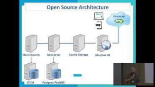
DEVELOPMENT OF GEOSPATIAL MAP BASED PORTAL FOR DELIMITATION OF MCD WARDS ; volume:XLII-2/W7 ; year:2017 ; pages:49-52
The International Archives of the Photogrammetry, Remote Sensing and Spatial Information Sciences ; XLII-2/W7 (2017), 49-52
- Creator
-
Kumar Chandra Gupta, A.
Kumar, P.
Kumar Sharma, P.
- DOI
-
10.5194/isprs-archives-XLII-2-W7-49-2017
- URN
-
urn:nbn:de:101:1-201711107409
- Rights
-
Open Access; Der Zugriff auf das Objekt ist unbeschränkt möglich.
- Last update
-
15.08.2025, 7:32 AM CEST
Data provider
This object is provided by:
Deutsche Nationalbibliothek. If you have any questions about the object, please contact the data provider.
Deutsche Nationalbibliothek. If you have any questions about the object, please contact the data provider.
Associated
- Kumar Chandra Gupta, A.
- Kumar, P.
- Kumar Sharma, P.
Other Objects (12)

Development of Geospatial Map Based Election Portal
DEVELOPMENT OF GEOSPATIAL MAP BASED PORTAL FOR NEW DELHI MUNICIPAL COUNCIL
Delimitation
govmap - Israeli geo-spatial portal

Talk to the map - AI driven geospatial mapshup
Examining Map Projection Distortions using Geospatial Web Tools
Commission de delimitation
Open Green Map - a geospatial tool for sustainable living
Revelation of ‘Hidden’ Balinese Geospatial Heritage on A Map
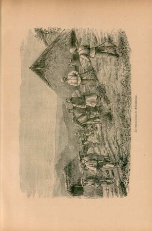
La commission de délimitation
La Délimitation De Zinder.
La délimitation Franco-espagnole.
Development of Geospatial Map Based Election Portal
DEVELOPMENT OF GEOSPATIAL MAP BASED PORTAL FOR NEW DELHI MUNICIPAL COUNCIL
Delimitation
govmap - Israeli geo-spatial portal
Talk to the map - AI driven geospatial mapshup
Examining Map Projection Distortions using Geospatial Web Tools
Commission de delimitation
Open Green Map - a geospatial tool for sustainable living
Revelation of ‘Hidden’ Balinese Geospatial Heritage on A Map
La commission de délimitation
La Délimitation De Zinder.