Luftbildpläne
Hönnetal Bl. 2, Gauß-Krüger-Koordinaten: Rechtswert: 3418, Hochwert: 5694
- Reference number
-
RW 0437, 85
- Dimensions
-
Maßstab: 1:5.000
- Further information
-
Land: NRW
- Context
-
Hansa Luftbild AG, Luftbildpläne 1926 - 1971 >> 3. 34 >> 3.9. 3418
- Holding
-
RW 0437 Hansa Luftbild AG, Luftbildpläne 1926 - 1971
- Creator
-
Hersteller: Hansa Luftbild
- Provenance
-
Hansa Luftbild
- Date of creation
-
06.04.1963
- Other object pages
- Delivered via
- Last update
-
2025-04-30T14:52:18+0200
Data provider
This object is provided by:
Landesarchiv Nordrhein-Westfalen. Abteilung Rheinland. If you have any questions about the object, please contact the data provider.
Landesarchiv Nordrhein-Westfalen. Abteilung Rheinland. If you have any questions about the object, please contact the data provider.
Object type
- Luftbildpläne
Associated
- Hersteller: Hansa Luftbild
- Hansa Luftbild
Time of origin
- 06.04.1963
Other Objects (12)
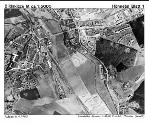
Hönnetal Bl. 1, Gauß-Krüger-Koordinaten: Rechtswert: 3418, Hochwert: 5696
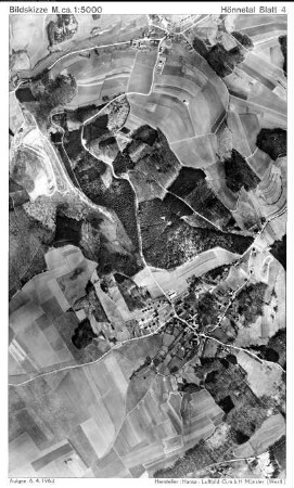
Hönnetal Bl. 4, Gauß-Krüger-Koordinaten: Rechtswert: 3422, Hochwert: 5694
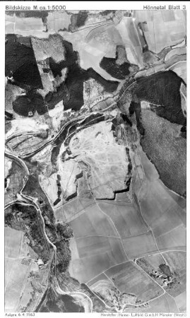
Hönnetal Bl. 3, Gauß-Krüger-Koordinaten: Rechtswert: 3420, Hochwert: 5694

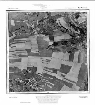
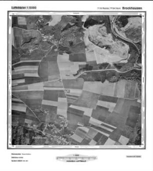
Brockhausen, Gauß-Krüger-Koordinaten: Rechtswert: 3418, Hochwert: 5694
Brockhausen, Gauß-Krüger-Koordinaten: Rechtswert: 3418, Hochwert: 5694
Brockhausen, Gauß-Krüger-Koordinaten: Rechtswert: 3418, Hochwert: 5694
Brockhausen, Gauß-Krüger-Koordinaten: Rechtswert: 3418, Hochwert: 5694
Brockhausen, Gauß-Krüger-Koordinaten: Rechtswert: 3418, Hochwert: 5694
Brockhausen, Gauß-Krüger-Koordinaten: Rechtswert: 3418, Hochwert: 5694
Topoführer Hönnetal
Fußgängerschutzweg, Hönnetal
Schutzaktion im Hönnetal
Hönnetal Bl. 1, Gauß-Krüger-Koordinaten: Rechtswert: 3418, Hochwert: 5696
Hönnetal Bl. 4, Gauß-Krüger-Koordinaten: Rechtswert: 3422, Hochwert: 5694
Hönnetal Bl. 3, Gauß-Krüger-Koordinaten: Rechtswert: 3420, Hochwert: 5694
Brockhausen, Gauß-Krüger-Koordinaten: Rechtswert: 3418, Hochwert: 5694
Brockhausen, Gauß-Krüger-Koordinaten: Rechtswert: 3418, Hochwert: 5694
Brockhausen, Gauß-Krüger-Koordinaten: Rechtswert: 3418, Hochwert: 5694
Brockhausen, Gauß-Krüger-Koordinaten: Rechtswert: 3418, Hochwert: 5694
Brockhausen, Gauß-Krüger-Koordinaten: Rechtswert: 3418, Hochwert: 5694
Brockhausen, Gauß-Krüger-Koordinaten: Rechtswert: 3418, Hochwert: 5694
Topoführer Hönnetal
Fußgängerschutzweg, Hönnetal