The Centennial Edition of the 1908 Alpenverein Map of the Brenta Massif, Italy
Abstract: The synergetic use of different traditional and, above all, modern techniques and technologies permitted the time-efficient production of a Centennial Edition of the world-famous high-mountain map of the Brenta Massif, first published in 1908. During the updating field survey in this extreme alpine terrain, classical cartographic field-sketching, terrestrial laser scanning, and geotagged landscape (stereo) photographing, together with measurements by geodetic and handheld GPS, were applied. Satellite imagery and digital image processing supported the digital cartographic work. However, glacier retreat areas had to be complemented by classical manual rock and scree drawing in the unique style of Aegerter-Rohn in order to maintain a homogeneous appearance of the re-used terrain depiction of the first edition. https://www.erdkunde.uni-bonn.de/article/view/2653
- Location
-
Deutsche Nationalbibliothek Frankfurt am Main
- Extent
-
Online-Ressource
- Language
-
Englisch
- Bibliographic citation
-
The Centennial Edition of the 1908 Alpenverein Map of the Brenta Massif, Italy ; volume:64 ; number:2 ; year:2010
Erdkunde ; 64, Heft 2 (2010)
- Creator
-
Buchroithner, Manfred F.
Himpel, Thomas
- DOI
-
10.3112/erdkunde.2010.02.06
- URN
-
urn:nbn:de:101:1-2410281815516.212257862340
- Rights
-
Open Access; Der Zugriff auf das Objekt ist unbeschränkt möglich.
- Last update
-
15.08.2025, 7:26 AM CEST
Data provider
Deutsche Nationalbibliothek. If you have any questions about the object, please contact the data provider.
Associated
- Buchroithner, Manfred F.
- Himpel, Thomas
Other Objects (12)

The Brentano centennial
Contributions to the Centennial Exhibition
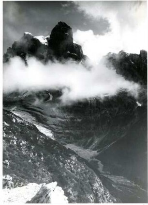
Alpen, Trentino, Brenta, Crozzon di Brenta
Centennial

Brenta-Villen

Brenta-Villen
Centennial Centre of Science and Technology, The
(Tribune 14 Sept. 69): The Humboldt Centennial
Heat flow map of the Bohemian Massif
Orchestra of the Future - The L.A. Philarmonic celebrates its centennial
Toeplitz centennial
Erdős centennial
The Brentano centennial
Contributions to the Centennial Exhibition
Alpen, Trentino, Brenta, Crozzon di Brenta
Centennial
Brenta-Villen
Brenta-Villen
Centennial Centre of Science and Technology, The
(Tribune 14 Sept. 69): The Humboldt Centennial
Heat flow map of the Bohemian Massif
Orchestra of the Future - The L.A. Philarmonic celebrates its centennial
Toeplitz centennial