- Alternative title
-
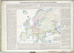
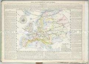
GEOGRAPHISCH- / HISTORISCHER / ATLAS / von Europa
- Location
-
Deutsches Historisches Museum, Berlin
- Inventory number
-
Do 2006/815.1-13
- Measurements
-
Höhe x Breite: 50,5 x 36 cm, Tiefe: 1 cm (Atlas (geschlossen))
Höhe x Breite: 50,5 x 70 cm (Atlas (aufgeschlagen))
- Material/Technique
-
Papier, Lithographie, koloriert
- Classification
-
Kartografie (Gattung)
- Subject (what)
-
Europa
- Event
-
Herstellung
- (who)
-
Geograph, Kartograf: Constant Desjardins
Historiker, Topograph, Ethnograph: Joseph Vincenz Häufler
Kunsthandlung: Kunsthandlung H. F. Müller
- (where)
-
Wien, Österreich [historisch: Österreich, Kaiserreich]
- (when)
-
1838
- Rights
-
Deutsches Historisches Museum
- Last update
-
24.03.2023, 9:31 AM CET
Data provider
This object is provided by:
Stiftung Deutsches Historisches Museum. If you have any questions about the object, please contact the data provider.
Stiftung Deutsches Historisches Museum. If you have any questions about the object, please contact the data provider.
Object type
- Historisch-Politische Karte
Associated
- Geograph, Kartograf: Constant Desjardins
- Historiker, Topograph, Ethnograph: Joseph Vincenz Häufler
- Kunsthandlung: Kunsthandlung H. F. Müller
Time of origin
- 1838
Other Objects (12)

Geographisch-historischer Atlas von Europa
Geographisch-Historischer Atlas von Europa: Europa's Mittelalter
Historischer und geographischer Atlas von Europa, 1
Historischer und geographischer Atlas von Europa, 1
Geographisch-Historischer Atlas von Europa: Hydrographische Karte von Europa
Geographisch-Historischer Atlas von Europa: Ethnographische Karte von Europa

Historischer und geographischer Atlas von Europa, 2,2
Historischer und geographischer Atlas von Europa, 2,2

Historischer und geographischer Atlas von Europa, 2,1
Historischer und geographischer Atlas von Europa, 2,1
Historisch-geographischer Atlas
Geographisch-Historischer Atlas von Europa: Klima- und Naturproducten-Karte von Europa
Geographisch-historischer Atlas von Europa
Geographisch-Historischer Atlas von Europa: Europa's Mittelalter
Historischer und geographischer Atlas von Europa, 1
Historischer und geographischer Atlas von Europa, 1
Geographisch-Historischer Atlas von Europa: Hydrographische Karte von Europa
Geographisch-Historischer Atlas von Europa: Ethnographische Karte von Europa
Historischer und geographischer Atlas von Europa, 2,2
Historischer und geographischer Atlas von Europa, 2,2
Historischer und geographischer Atlas von Europa, 2,1
Historischer und geographischer Atlas von Europa, 2,1
Historisch-geographischer Atlas