Landkarte
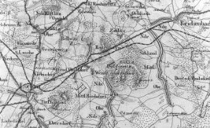
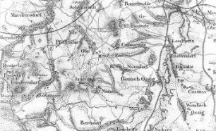
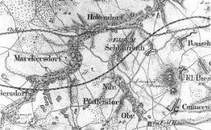
Markersdorf-Deutsch-Paulsdorf. Topographische Karte vom Preußischen Staate, Bl. 265 Reichenbach, aufgen. 1815, grav. 1828
Negativ in schwarzweiß
- Alternative title
-
Mühlenarchiv Rapp - Karten (Serientitel)
- Other number(s)
-
df_rp-c_0880005 (Aufnahmenummer)
70509093 (Dokumentennummer)
- Material/Technique
-
Originalnegativ (Fotografie)
- Subject (where)
-
Markersdorf-Deutsch-Paulsdorf (Standort)
- Event
-
Fotografische Aufnahme
- (who)
-
Rapp, Günter (Fotograf)
- Rights
-
Bitte beachten Sie die Nutzungsbedingungen der Deutschen Fotothek.
- Last update
-
05.03.2025, 4:33 PM CET
Data provider
This object is provided by:
Deutsche Fotothek. If you have any questions about the object, please contact the data provider.
Deutsche Fotothek. If you have any questions about the object, please contact the data provider.
Object type
- Landkarte
Associated
- Rapp, Günter (Fotograf)
Other Objects (12)
Markersdorf-Deutsch-Paulsdorf. Topographische Karte vom Preußischen Staate, Bl. 265 Reichenbach, aufgen. 1815, grav. 1828
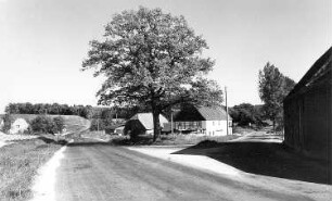
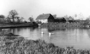
Markersdorf-Deutsch-Paulsdorf. Ehem. Wassermühle
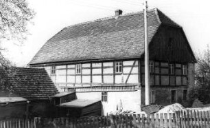
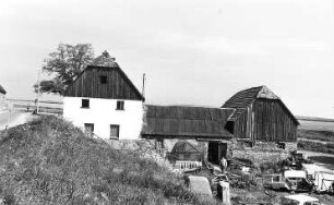
Markersdorf-Deutsch-Paulsdorf. Ehem. Wassermühle
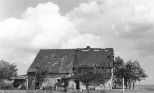
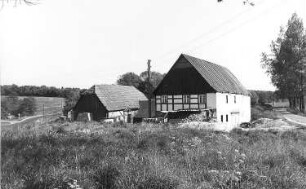
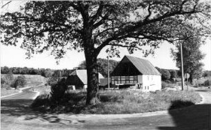
Markersdorf-Deutsch-Paulsdorf. Ehem. Windmühlengehöft
Markersdorf-Deutsch-Paulsdorf. Ehem. Wassermühle
Markersdorf-Deutsch-Paulsdorf. Ehem. Wassermühle
Markersdorf-Deutsch-Paulsdorf. Ehem. Wassermühle
Markersdorf-Deutsch-Paulsdorf. Ehem. Wassermühle
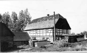
Markersdorf-Deutsch-Paulsdorf. Ehem. Wassermühle
Markersdorf. Topographische Karte vom Preußischen Staate, Bl. 266 Görlitz, aufgen. 1815, grav. 1827, Nachträge 1866
Markersdorf. Topographische Karte vom Preußischen Staate, Bl. 266 Görlitz, aufgen. 1815, grav. 1827, Nachträge 1866
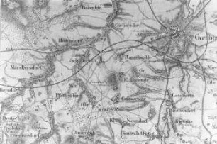
Markersdorf. Topographische Karte vom Preußischen Staate, Bl. 266 Görlitz, aufgen. 1815, grav. 1827, Nachträge 1866
Markersdorf-Deutsch-Paulsdorf. Topographische Karte vom Preußischen Staate, Bl. 265 Reichenbach, aufgen. 1815, grav. 1828
Markersdorf-Deutsch-Paulsdorf. Ehem. Wassermühle
Markersdorf-Deutsch-Paulsdorf. Ehem. Wassermühle
Markersdorf-Deutsch-Paulsdorf. Ehem. Windmühlengehöft
Markersdorf-Deutsch-Paulsdorf. Ehem. Wassermühle
Markersdorf-Deutsch-Paulsdorf. Ehem. Wassermühle
Markersdorf-Deutsch-Paulsdorf. Ehem. Wassermühle
Markersdorf-Deutsch-Paulsdorf. Ehem. Wassermühle
Markersdorf-Deutsch-Paulsdorf. Ehem. Wassermühle
Markersdorf. Topographische Karte vom Preußischen Staate, Bl. 266 Görlitz, aufgen. 1815, grav. 1827, Nachträge 1866
Markersdorf. Topographische Karte vom Preußischen Staate, Bl. 266 Görlitz, aufgen. 1815, grav. 1827, Nachträge 1866
Markersdorf. Topographische Karte vom Preußischen Staate, Bl. 266 Görlitz, aufgen. 1815, grav. 1827, Nachträge 1866
Markersdorf-Deutsch-Paulsdorf. Topographische Karte vom Preußischen Staate, Bl. 265 Reichenbach, aufgen. 1815, grav. 1828
Markersdorf-Deutsch-Paulsdorf. Ehem. Wassermühle
Markersdorf-Deutsch-Paulsdorf. Ehem. Wassermühle
Markersdorf-Deutsch-Paulsdorf. Ehem. Windmühlengehöft
Markersdorf-Deutsch-Paulsdorf. Ehem. Wassermühle
Markersdorf-Deutsch-Paulsdorf. Ehem. Wassermühle
Markersdorf-Deutsch-Paulsdorf. Ehem. Wassermühle
Markersdorf-Deutsch-Paulsdorf. Ehem. Wassermühle
Markersdorf-Deutsch-Paulsdorf. Ehem. Wassermühle
Markersdorf. Topographische Karte vom Preußischen Staate, Bl. 266 Görlitz, aufgen. 1815, grav. 1827, Nachträge 1866
Markersdorf. Topographische Karte vom Preußischen Staate, Bl. 266 Görlitz, aufgen. 1815, grav. 1827, Nachträge 1866