Karten / Pläne
Gladbeck (Gladbeck) Flächennutzungsplan mit 2. Änderung von 1974 1968/75 1 : 10 000 102 x 79 farb. Druck Regierung Münster
- Former reference number
-
Regierung Münster
- Further information
-
Ort: Gladbeck, Gladbeck
- Context
-
Karten A (Allgemein) >> 2. Land- und Forstwirtschaft >> 2.11. Flächennutzungspläne
- Holding
-
W 051 Karten A (Allgemein)
- Indexentry place
-
Gladbeck, Gladbeck
Gladbeck, Flächennutzungsplan, 1975
- Provenance
-
Sammlungsregistraturbildner
- Date of creation
-
1975
- Other object pages
- Delivered via
- Last update
-
24.06.2025, 1:54 PM CEST
Data provider
This object is provided by:
Landesarchiv Nordrhein-Westfalen. Abteilung Westfalen. If you have any questions about the object, please contact the data provider.
Landesarchiv Nordrhein-Westfalen. Abteilung Westfalen. If you have any questions about the object, please contact the data provider.
Object type
- Karten / Pläne
Associated
- Sammlungsregistraturbildner
Time of origin
- 1975
Other Objects (12)
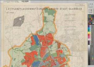
Gladbeck (Gladbeck) Leitplan - Flächennutzungsplan 1963 1 : 10 000 103 x 79 farb. Druck Regierung Münster
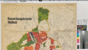
Gladbeck (Gladbeck) Raumordnungskataster 1963 1 : 10 000 102 x 79 farb. Druck Regierung Münster

Gladbeck-Bottrop, Gladbeck-Mitte, Gladbeck-Brauck; Gladbeck-Zweckel; Gladbeck-Markuskirche

Gladbeck (Gladbeck) Stadtplan 1953 1 : 25000 41 x 34 farb. Druck Stadtvermessungsamt Gladbeck Oberpostdirektion Münster Nr. 2456

Gladbeck (Gladbeck) Postzustellungsbezirke nach 1953 1 : 25000 41 x 34 Einzeichnung in farb. Druck: Stadtplan Gladbeck Stadtvermessungsamt Gladbeck Oberpostdirektion Münster Nr. 2456
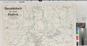
Gladbeck (Gladbeck) Stadtplan 1925 1 : 10 000 98,5 x 79 Druck: Stadtvermessungsamt, Gladbeck Oberpostdirektion Münster
Gladbeck

Gladbeck
Gladbeck
Gladbeck
Katasteramt Gladbeck Stadtkreis Gladbeck, Deckblatt 1
Katasteramt Gladbeck Stadtkreis Gladbeck, Deckblatt 1
Gladbeck (Gladbeck) Leitplan - Flächennutzungsplan 1963 1 : 10 000 103 x 79 farb. Druck Regierung Münster
Gladbeck (Gladbeck) Raumordnungskataster 1963 1 : 10 000 102 x 79 farb. Druck Regierung Münster
Gladbeck-Bottrop, Gladbeck-Mitte, Gladbeck-Brauck; Gladbeck-Zweckel; Gladbeck-Markuskirche
Gladbeck (Gladbeck) Stadtplan 1953 1 : 25000 41 x 34 farb. Druck Stadtvermessungsamt Gladbeck Oberpostdirektion Münster Nr. 2456
Gladbeck (Gladbeck) Postzustellungsbezirke nach 1953 1 : 25000 41 x 34 Einzeichnung in farb. Druck: Stadtplan Gladbeck Stadtvermessungsamt Gladbeck Oberpostdirektion Münster Nr. 2456
Gladbeck (Gladbeck) Stadtplan 1925 1 : 10 000 98,5 x 79 Druck: Stadtvermessungsamt, Gladbeck Oberpostdirektion Münster
Gladbeck
Gladbeck
Gladbeck
Gladbeck
Katasteramt Gladbeck Stadtkreis Gladbeck, Deckblatt 1
Katasteramt Gladbeck Stadtkreis Gladbeck, Deckblatt 1
Gladbeck (Gladbeck) Leitplan - Flächennutzungsplan 1963 1 : 10 000 103 x 79 farb. Druck Regierung Münster
Gladbeck (Gladbeck) Raumordnungskataster 1963 1 : 10 000 102 x 79 farb. Druck Regierung Münster
Gladbeck-Bottrop, Gladbeck-Mitte, Gladbeck-Brauck; Gladbeck-Zweckel; Gladbeck-Markuskirche
Gladbeck (Gladbeck) Stadtplan 1953 1 : 25000 41 x 34 farb. Druck Stadtvermessungsamt Gladbeck Oberpostdirektion Münster Nr. 2456
Gladbeck (Gladbeck) Postzustellungsbezirke nach 1953 1 : 25000 41 x 34 Einzeichnung in farb. Druck: Stadtplan Gladbeck Stadtvermessungsamt Gladbeck Oberpostdirektion Münster Nr. 2456
Gladbeck (Gladbeck) Stadtplan 1925 1 : 10 000 98,5 x 79 Druck: Stadtvermessungsamt, Gladbeck Oberpostdirektion Münster
Gladbeck
Gladbeck
Gladbeck
Gladbeck
Katasteramt Gladbeck Stadtkreis Gladbeck, Deckblatt 1