Verzeichnung
Karte der Kolonie Moordorf nach der Brixschen Vermessung von 1808, von neuem vermessen und reguliert im Juli 1811 Kolorierte Karte von J.D. Köhnemann, Moorvogt Papier Format 36,5x69 cm M 1:
- Reference number
-
NLA HA, Rep. 244, B Nr. 74
- Former reference number
-
Rep. 244, 316 B
Rep. 244 B 316
- Further information
-
Ergänzungen: Klassifikation TeilB: Moordorf
- Context
-
Kartensammlung >> 5 Regierungsbezirk Weser-Ems >> 3 Kreis Aurich >> 5 Feldmarken, Stadt- und Ortspläne, Flurstücke
- Holding
-
Rep. 244 Kartensammlung
- Indexentry person
-
Sprengell, F. W.
- Indexentry place
-
Moordorf, Kolonie
- Date of creation
-
- 1811
- Other object pages
- Last update
-
16.06.2025, 1:30 PM CEST
Data provider
This object is provided by:
Niedersächsisches Landesarchiv. If you have any questions about the object, please contact the data provider.
Niedersächsisches Landesarchiv. If you have any questions about the object, please contact the data provider.
Object type
- Verzeichnung
Time of origin
- - 1811
Other Objects (12)

Köhnemann, Hans
Köhnemann, Carl Friedrich
Köhnemann, Heinrich Adolf
Köhnemann; Rendant; Berlin
Köhnemann, Johann (Schneider)
Köhnemann, Helmut, Rheine, Kino
Moordorf (Ostfriesland)
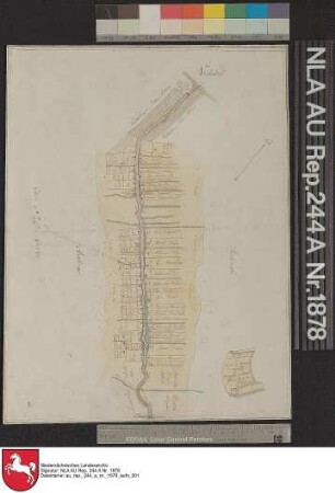
Plan von der Kolonie MOORDORF Kolorierte Zeichnung von Moorvogt Köhnemann Papier auf Leinen Format 39,6x30,2 M 1:5.000 (ca)
Emder Segelverein (ESV): Vereinsgaststätte Köhnemann
Köhnemann, Wilfried (Innenarchitekt, geb. 1933)
Moormuseum Moordorf (Bestand)
Nervenfieber in Moordorf
Köhnemann, Hans
Köhnemann, Carl Friedrich
Köhnemann, Heinrich Adolf
Köhnemann; Rendant; Berlin
Köhnemann, Johann (Schneider)
Köhnemann, Helmut, Rheine, Kino
Moordorf (Ostfriesland)
Plan von der Kolonie MOORDORF Kolorierte Zeichnung von Moorvogt Köhnemann Papier auf Leinen Format 39,6x30,2 M 1:5.000 (ca)
Emder Segelverein (ESV): Vereinsgaststätte Köhnemann
Köhnemann, Wilfried (Innenarchitekt, geb. 1933)
Moormuseum Moordorf (Bestand)