- Alternative title
-
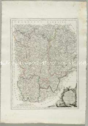
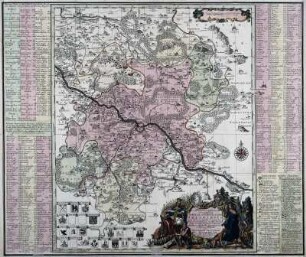
CARTE / des Gouvernements / DE LORRAINE ET / D'ALSACE
- Location
-
Deutsches Historisches Museum, Berlin
- Inventory number
-
Do 2006/854
- Measurements
-
Höhe x Breite: 54,5 x 78 cm (Blatt)
Höhe x Breite: 40,6 x 55 cm (Karte)
Höhe x Breite: 44,3 x 58,5 cm (Platte)
- Material/Technique
-
Papier, Kupferstich, grenzkoloriert
- Classification
-
Kartografie (Gattung)
- Subject (what)
-
Frankreich
Lothringen
Elsass
- Event
-
Herstellung
- (who)
-
Kartograf: Rigobert Bonne
Stecher, Kartograf: Paolo Santini
- (where)
-
Venedig, Italien
- (when)
-
1777
- Rights
-
Deutsches Historisches Museum
- Last update
-
24.03.2023, 9:31 AM CET
Data provider
This object is provided by:
Stiftung Deutsches Historisches Museum. If you have any questions about the object, please contact the data provider.
Stiftung Deutsches Historisches Museum. If you have any questions about the object, please contact the data provider.
Object type
- Ämterkarte
Associated
- Kartograf: Rigobert Bonne
- Stecher, Kartograf: Paolo Santini
Time of origin
- 1777
Other Objects (12)
Carte des Gouvernements de Dauphiné et de Provence
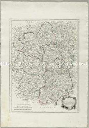
Carte des Gouvernements de Languedoc, de Foix et de Roussillon
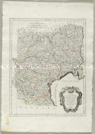
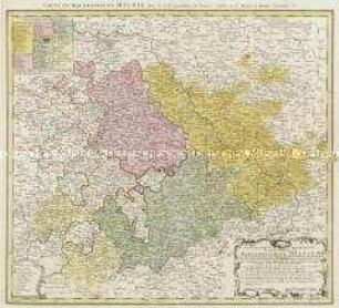
Carte des Gouvernements de Bourgogne, de Franche Comté et de Lyonnois
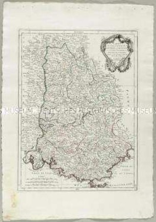
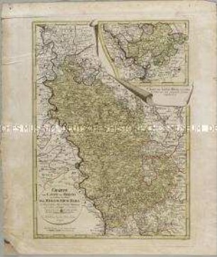
Carte des Gouvernements du Berri, du Nivernois, de la Marche, du Bourbonnois, du Limosin et de l'Auvergne
![Karte vom Erzgebirgischen Kreis, 1:170 000, Kupferstich, um 1757 : Carte Von Ertzgebürgischen Creyss, In Churfürstenthum Sachssen : mit allen darinnen befindlichen Aemtern wie solche eingetheilet, und zwar: I. Die Aemter Zwikau und Werda, IIa. Wiesenburg, IIb. Amt Schwartzenberg, III. Amt Chemniz, IV. Amt Stollberg, V. Amt Grünheyn, VI. Amt Wolkenstein, IIV. Amt Lauterstein, VIII. Amt Augustusburg, IX. Amt Frankenberg, X. Amt Nossen, XI. Amt Freyberg, XII. Amt Grillenburg, XIII. Amt Frauenstein, XIV. Amt Altenberg, XV. Amt Dippoldiswalda, Ingleichen derer im Meisnischen Creys gelegenen Aemter: XVI. Amt Pirna und der Herrschafft Lauenstein, XVII. Amt Lohmen, XVIII. Amt Hohenstein, und denen Gräflich Schoenburgischen, im Marggrafthum Meissen belegenen Herrschafften und Aemteren, als A. Reichs-Herrschafften Glauchau und Lichtenstein, B. Rs. Grafschafft Hartenstein und Herschafft Stein, C. Amt Remissau, D. Reichs-Herrschafft Waldenburg, E. Amt Penig, F. Amt Rochsburg, G. Amt Wechselburg ; mit Königl. und Churfursl. Sachss. Privilegio / [Zeichner d. Kt.: A. F. Zürner]. - [Ca. 1:170 000]. - Amsterdam : P. Schenk , [um 1757]. - 1 Kt. auf 2 Bl. : Kupferst. ; Gesamtgr. 100 x 59 cm, je Teil 50 x 59 cm](https://iiif.deutsche-digitale-bibliothek.de/image/2/06fe17a1-809d-4b93-b9da-b1208d856532/full/!306,450/0/default.jpg)
Karte vom Erzgebirgischen Kreis, 1:170 000, Kupferstich, um 1757 : Carte Von Ertzgebürgischen Creyss, In Churfürstenthum Sachssen : mit allen darinnen befindlichen Aemtern wie solche eingetheilet, und zwar: I. Die Aemter Zwikau und Werda, IIa. Wiesenburg, IIb. Amt Schwartzenberg, III. Amt Chemniz, IV. Amt Stollberg, V. Amt Grünheyn, VI. Amt Wolkenstein, IIV. Amt Lauterstein, VIII. Amt Augustusburg, IX. Amt Frankenberg, X. Amt Nossen, XI. Amt Freyberg, XII. Amt Grillenburg, XIII. Amt Frauenstein, XIV. Amt Altenberg, XV. Amt Dippoldiswalda, Ingleichen derer im Meisnischen Creys gelegenen Aemter: XVI. Amt Pirna und der Herrschafft Lauenstein, XVII. Amt Lohmen, XVIII. Amt Hohenstein, und denen Gräflich Schoenburgischen, im Marggrafthum Meissen belegenen Herrschafften und Aemteren, als A. Reichs-Herrschafften Glauchau und Lichtenstein, B. Rs. Grafschafft Hartenstein und Herschafft Stein, C. Amt Remissau, D. Reichs-Herrschafft Waldenburg, E. Amt Penig, F. Amt Rochsburg, G. Amt Wechselburg ; mit Königl. und Churfursl. Sachss. Privilegio / [Zeichner d. Kt.: A. F. Zürner]. - [Ca. 1:170 000]. - Amsterdam : P. Schenk , [um 1757]. - 1 Kt. auf 2 Bl. : Kupferst. ; Gesamtgr. 100 x 59 cm, je Teil 50 x 59 cm
Diocese u. Amt Dresden, 1:110 000, Kupferstich, 1757 : Seutter, Matthaeus: Diocese u. Amt Dresden, um 1757, ca. 1:110 000. Zeichner: (Adam Friedrich Zürner) 38,6 x 47,1 cm (Kupferstich, kol.)
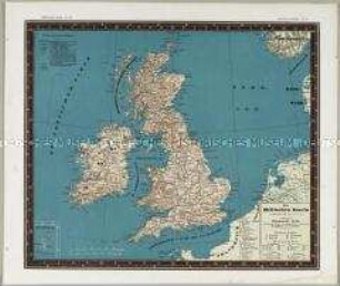
Bauerkeller's Handatlas der allgemeinen Erdkunde, der Länder- und Staatenkunde: Die Britischen Inseln. Mit einer Nebenkarte: Shetlands-Inseln
Geographische Abbildung des gantzen Umfangs der Marggrafschaft Meissen
Charte vom Laufe des Rheins von Coblenz bis Wesel. Mit einer Anschlusskarte: Charte den Lauf des Rheins von Coblenz bis Unkel... enthaltend
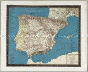
Bauerkeller's Handatlas der allgemeinen Erdkunde, der Länder- und Staatenkunde: Spanien und Portugal
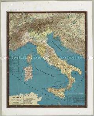
Bauerkeller's Handatlas der allgemeinen Erdkunde, der Länder- und Staatenkunde: Italien
![Karte der Ämter Rochlitz, Colditz und Leissnig, ca. 1:260 000, Kupferstich, 1759 : Haute-Saxe, Bailliage De Rochliz, Coldiz Et Leissnig. - [Ca. 1:260 000]. - [Paris] : [Le Rouge] , [1759]. - 1 Kt. : Kupferst. ; 27 x 20 cm](https://iiif.deutsche-digitale-bibliothek.de/image/2/6609d286-764b-4340-8df8-b0dee5a59688/full/!306,450/0/default.jpg)
Karte der Ämter Rochlitz, Colditz und Leissnig, ca. 1:260 000, Kupferstich, 1759 : Haute-Saxe, Bailliage De Rochliz, Coldiz Et Leissnig. - [Ca. 1:260 000]. - [Paris] : [Le Rouge] , [1759]. - 1 Kt. : Kupferst. ; 27 x 20 cm
Carte des Gouvernements de Dauphiné et de Provence
Carte des Gouvernements de Languedoc, de Foix et de Roussillon
Carte des Gouvernements de Bourgogne, de Franche Comté et de Lyonnois
Carte des Gouvernements du Berri, du Nivernois, de la Marche, du Bourbonnois, du Limosin et de l'Auvergne
Karte vom Erzgebirgischen Kreis, 1:170 000, Kupferstich, um 1757 : Carte Von Ertzgebürgischen Creyss, In Churfürstenthum Sachssen : mit allen darinnen befindlichen Aemtern wie solche eingetheilet, und zwar: I. Die Aemter Zwikau und Werda, IIa. Wiesenburg, IIb. Amt Schwartzenberg, III. Amt Chemniz, IV. Amt Stollberg, V. Amt Grünheyn, VI. Amt Wolkenstein, IIV. Amt Lauterstein, VIII. Amt Augustusburg, IX. Amt Frankenberg, X. Amt Nossen, XI. Amt Freyberg, XII. Amt Grillenburg, XIII. Amt Frauenstein, XIV. Amt Altenberg, XV. Amt Dippoldiswalda, Ingleichen derer im Meisnischen Creys gelegenen Aemter: XVI. Amt Pirna und der Herrschafft Lauenstein, XVII. Amt Lohmen, XVIII. Amt Hohenstein, und denen Gräflich Schoenburgischen, im Marggrafthum Meissen belegenen Herrschafften und Aemteren, als A. Reichs-Herrschafften Glauchau und Lichtenstein, B. Rs. Grafschafft Hartenstein und Herschafft Stein, C. Amt Remissau, D. Reichs-Herrschafft Waldenburg, E. Amt Penig, F. Amt Rochsburg, G. Amt Wechselburg ; mit Königl. und Churfursl. Sachss. Privilegio / [Zeichner d. Kt.: A. F. Zürner]. - [Ca. 1:170 000]. - Amsterdam : P. Schenk , [um 1757]. - 1 Kt. auf 2 Bl. : Kupferst. ; Gesamtgr. 100 x 59 cm, je Teil 50 x 59 cm
Diocese u. Amt Dresden, 1:110 000, Kupferstich, 1757 : Seutter, Matthaeus: Diocese u. Amt Dresden, um 1757, ca. 1:110 000. Zeichner: (Adam Friedrich Zürner) 38,6 x 47,1 cm (Kupferstich, kol.)
Bauerkeller's Handatlas der allgemeinen Erdkunde, der Länder- und Staatenkunde: Die Britischen Inseln. Mit einer Nebenkarte: Shetlands-Inseln
Geographische Abbildung des gantzen Umfangs der Marggrafschaft Meissen
Charte vom Laufe des Rheins von Coblenz bis Wesel. Mit einer Anschlusskarte: Charte den Lauf des Rheins von Coblenz bis Unkel... enthaltend
Bauerkeller's Handatlas der allgemeinen Erdkunde, der Länder- und Staatenkunde: Spanien und Portugal
Bauerkeller's Handatlas der allgemeinen Erdkunde, der Länder- und Staatenkunde: Italien