Abschnitt | Altkarte | Karte | map
Mappa Geographica Circuli Metalliferi Electoratus Saxoniæ cum omnibus, quæ in eo comprehenduntur Præfecturis Et Dynastiis : quales sunt I. Præf. Zwickavienses, II. Præf. Schwarzenbergens. III. Dyn. Hartenstein, IV. Glaucha, V. Præf. Lemsa, VI. Præf. Waldenburg, VII Præf. Rochsburg, VIII. Præf. Penig, IX. Præf. Wechselburg, X. Præf. Chemnit, XI Præf. Stollberg, XII. Præf. Grunhayn, XIII. Præf. Wolckenstain, XIV. Præf. Lauterstein, XV. Præf. Augustopolit. XVI. Præf. Franckenberg, XVII. Præf. Nossen, XVIII. Præf. Freyberg, XIX. Præf. Grullenburg, XX Præf. Frauenstein, XXI Præf. Altenberg, XXII Præf. Dippoldiswalda, Accedunt præfecturæ circuli Misnici XXIII. Præf. Pirnensis cum Dyn. Lauenstein, XXIV. Præf. Loehmen, XXV. Præf. Hohenstein

- Alternative title
-
Mappa Geographica Circuli Metalliferi Electoratus Saxoniae cum omnibus, quae in eo comprehenduntur Praefecturis Et Dynastiis
- Extent
-
1 Karte auf 2 Blättern: Kupferstich, 2°
- Language
-
Latein
- Notes
-
Museum Burg Linn
cura Matth. Seutter, Geogr. Cæsar.
- Series
-
In einen Folio-Band neu eingebundene Sammlung von Karten des 18. Jahrhunderts, Deutschland und Mitteleuropa betreffend
- Contributor
- Published
-
Aug[ustae] Vind[elicorum] , 1739
- Provenance
-
1. Stadt Krefeld-Uerdingen, Stadtteil Uerdingen / 2. Heimathaus des Niederrheins
- URN
-
urn:nbn:de:hbz:061:1-1010202
- Last update
-
09.04.2025, 8:55 AM CEST
Data provider
This object is provided by:
Heinrich-Heine-Universität Düsseldorf. Universitäts- und Landesbibliothek Düsseldorf. If you have any questions about the object, please contact the data provider.
Heinrich-Heine-Universität Düsseldorf. Universitäts- und Landesbibliothek Düsseldorf. If you have any questions about the object, please contact the data provider.
Object type
- map ; Karte ; Altkarte ; Abschnitt
Associated
Time of origin
- Aug[ustae] Vind[elicorum] , 1739
Other Objects (12)
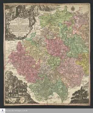
Mappa Geographica CIRCULI METALLIFERI Electoratus Saxoniae cum omnibus, quae in eo comprehenduntur PRAEFECTURIS ET DYNASTIIS : quales sunt I. Præf. Zwickavienses, II. Præf. Schwarzenbergens., III. Dyn. Hartenstein, IV. Glaucha, V. Præf. Lemsa, VI. Præf. Waldenburg, VII. Præf. Rochsburg, VIII. Præf. Penig, IX. Præf. Wechselburg, X. Præf. Chemnit, XI. Præf. Stollberg, XII Præf. Grunhayn, XIII. Præf. Wolckenstain, XIV. Præf. Lauterstein, XV. Præf. Augustopolit., XVI. Præf. Franckenberg, XVII. Præf. Nossen, XVIII. Præf. Freyberg, XIX. Præf. Grullenburg, XX. Præf. Frau-enstein, XXI. Præf. Altenberg, XXII. Præf. Dippoldiswalda, Accedunt præfecturæ circuli Misnici XXIII. Præf. Prinensis cum Dyn. Lauenstein, XXIV. Præf. Loehmen, XXV. Præf. Hohenstein ; Cum Priv. S. M. Polon. et Elect. Saxon.
![Karte vom Erzgebirgischen Kreis, 1:170 000, Kupferstich, nach 1739 : Mappa Geographica Circuli Metalliferi Electoratus Saxoniae cum omnibus, quae in eo comprehenduntur Praefecturis Et Dynastiis : quales sunt I. Praef. Zwickavienses, II. Praef. Schwarzenbergens. III. Dyn. Hartenstein, IV. Glaucha, V. Praef. Lemsa, VI. Praef. Waldenburg, VII Praef. Rochsburg, VIII. Praef. Penig, IX. Praef. Wechselburg, X. Praef. Chemnit, XI Praef. Stollberg, XII Praef. Grunhayn, XIII. Praef. Wolckenstain, XIV. Praef. Lauterstein, XV. Praef. Augustopolit. XVI. Praef. Franckenberg, XVII Praef. Nossen, XVIII Praef. Freyberg, XIX. Praef. Grullenburg, XX Praef. Frauenstein, XXI Praef. Altenberg, XXII Praef. Dippoldiswalda, Accedunt praefecturae circuli Misnici XXIII. Praef. Pirnensis cum Dyn. Lauenstein, XXIV. Praef. Loehmen, XXV. Praef. Hohenstein ; Cum Priv. S. M. Polon. et Elect. Saxon. / cura Matth. Seutter, Geogr. Caesar. Aug. Vind. Tob. Conr. Lotter sculpsit. - [Ca. 1:170 000]. - Aug. Vind. , [nach 1739]. - 1 Kt. auf 2 Bl. : Kupferst. ; Gesamtgr. 96 x 56 cm, je Teil 48 x 56 cm](https://iiif.deutsche-digitale-bibliothek.de/image/2/9d43eb1d-4b4a-4a2c-be87-c14b55858688/full/!306,450/0/default.jpg)
Karte vom Erzgebirgischen Kreis, 1:170 000, Kupferstich, nach 1739 : Mappa Geographica Circuli Metalliferi Electoratus Saxoniae cum omnibus, quae in eo comprehenduntur Praefecturis Et Dynastiis : quales sunt I. Praef. Zwickavienses, II. Praef. Schwarzenbergens. III. Dyn. Hartenstein, IV. Glaucha, V. Praef. Lemsa, VI. Praef. Waldenburg, VII Praef. Rochsburg, VIII. Praef. Penig, IX. Praef. Wechselburg, X. Praef. Chemnit, XI Praef. Stollberg, XII Praef. Grunhayn, XIII. Praef. Wolckenstain, XIV. Praef. Lauterstein, XV. Praef. Augustopolit. XVI. Praef. Franckenberg, XVII Praef. Nossen, XVIII Praef. Freyberg, XIX. Praef. Grullenburg, XX Praef. Frauenstein, XXI Praef. Altenberg, XXII Praef. Dippoldiswalda, Accedunt praefecturae circuli Misnici XXIII. Praef. Pirnensis cum Dyn. Lauenstein, XXIV. Praef. Loehmen, XXV. Praef. Hohenstein ; Cum Priv. S. M. Polon. et Elect. Saxon. / cura Matth. Seutter, Geogr. Caesar. Aug. Vind. Tob. Conr. Lotter sculpsit. - [Ca. 1:170 000]. - Aug. Vind. , [nach 1739]. - 1 Kt. auf 2 Bl. : Kupferst. ; Gesamtgr. 96 x 56 cm, je Teil 48 x 56 cm
![[Præf. Ad Lectores.]](https://iiif.deutsche-digitale-bibliothek.de/image/2/9889c6ed-2c92-4004-8306-2bc5e6906a76/full/!306,450/0/default.jpg)
[Præf. Ad Lectores.]
Præf. Ad Valer. Mag.
Steph. in Praef. ad Bell. aquat.

30. 31 Epithalamium Palladii c. praef.

25. 26 Bellum Geticum c. praef.

27. 28 Sextus Consulatus Honorii c. praef.
L. XXX. Idem A. Joanni Praef. Praet.
L. X. Imp. Justinianus A. Mennae Praef. Praet.
L. XI. & Ult. Idem A. Joanni Praef. Praet.
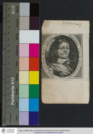
Arfriedus Com: De Wittemberg Præf: General: Belli Suecici
Mappa Geographica CIRCULI METALLIFERI Electoratus Saxoniae cum omnibus, quae in eo comprehenduntur PRAEFECTURIS ET DYNASTIIS : quales sunt I. Præf. Zwickavienses, II. Præf. Schwarzenbergens., III. Dyn. Hartenstein, IV. Glaucha, V. Præf. Lemsa, VI. Præf. Waldenburg, VII. Præf. Rochsburg, VIII. Præf. Penig, IX. Præf. Wechselburg, X. Præf. Chemnit, XI. Præf. Stollberg, XII Præf. Grunhayn, XIII. Præf. Wolckenstain, XIV. Præf. Lauterstein, XV. Præf. Augustopolit., XVI. Præf. Franckenberg, XVII. Præf. Nossen, XVIII. Præf. Freyberg, XIX. Præf. Grullenburg, XX. Præf. Frau-enstein, XXI. Præf. Altenberg, XXII. Præf. Dippoldiswalda, Accedunt præfecturæ circuli Misnici XXIII. Præf. Prinensis cum Dyn. Lauenstein, XXIV. Præf. Loehmen, XXV. Præf. Hohenstein ; Cum Priv. S. M. Polon. et Elect. Saxon.
Karte vom Erzgebirgischen Kreis, 1:170 000, Kupferstich, nach 1739 : Mappa Geographica Circuli Metalliferi Electoratus Saxoniae cum omnibus, quae in eo comprehenduntur Praefecturis Et Dynastiis : quales sunt I. Praef. Zwickavienses, II. Praef. Schwarzenbergens. III. Dyn. Hartenstein, IV. Glaucha, V. Praef. Lemsa, VI. Praef. Waldenburg, VII Praef. Rochsburg, VIII. Praef. Penig, IX. Praef. Wechselburg, X. Praef. Chemnit, XI Praef. Stollberg, XII Praef. Grunhayn, XIII. Praef. Wolckenstain, XIV. Praef. Lauterstein, XV. Praef. Augustopolit. XVI. Praef. Franckenberg, XVII Praef. Nossen, XVIII Praef. Freyberg, XIX. Praef. Grullenburg, XX Praef. Frauenstein, XXI Praef. Altenberg, XXII Praef. Dippoldiswalda, Accedunt praefecturae circuli Misnici XXIII. Praef. Pirnensis cum Dyn. Lauenstein, XXIV. Praef. Loehmen, XXV. Praef. Hohenstein ; Cum Priv. S. M. Polon. et Elect. Saxon. / cura Matth. Seutter, Geogr. Caesar. Aug. Vind. Tob. Conr. Lotter sculpsit. - [Ca. 1:170 000]. - Aug. Vind. , [nach 1739]. - 1 Kt. auf 2 Bl. : Kupferst. ; Gesamtgr. 96 x 56 cm, je Teil 48 x 56 cm
[Præf. Ad Lectores.]
Præf. Ad Valer. Mag.
Steph. in Praef. ad Bell. aquat.
30. 31 Epithalamium Palladii c. praef.
25. 26 Bellum Geticum c. praef.
27. 28 Sextus Consulatus Honorii c. praef.
L. XXX. Idem A. Joanni Praef. Praet.
L. X. Imp. Justinianus A. Mennae Praef. Praet.
L. XI. & Ult. Idem A. Joanni Praef. Praet.