Karte | map
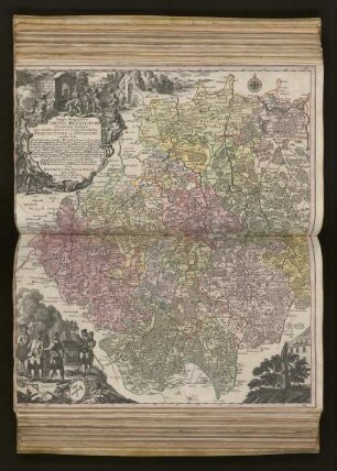
Mappa Geographica CIRCULI METALLIFERI Electoratus Saxoniae cum omnibus, quae in eo comprehenduntur PRAEFECTURIS ET DYNASTIIS : quales sunt I. Præf. Zwickavienses, II. Præf. Schwarzenbergens., III. Dyn. Hartenstein, IV. Glaucha, V. Præf. Lemsa, VI. Præf. Waldenburg, VII. Præf. Rochsburg, VIII. Præf. Penig, IX. Præf. Wechselburg, X. Præf. Chemnit, XI. Præf. Stollberg, XII Præf. Grunhayn, XIII. Præf. Wolckenstain, XIV. Præf. Lauterstein, XV. Præf. Augustopolit., XVI. Præf. Franckenberg, XVII. Præf. Nossen, XVIII. Præf. Freyberg, XIX. Præf. Grullenburg, XX. Præf. Frau-enstein, XXI. Præf. Altenberg, XXII. Præf. Dippoldiswalda, Accedunt præfecturæ circuli Misnici XXIII. Præf. Prinensis cum Dyn. Lauenstein, XXIV. Præf. Loehmen, XXV. Præf. Hohenstein ; Cum Priv. S. M. Polon. et Elect. Saxon.

- Umfang
-
1 Kt. auf 2 Bl ; Gesamtgr.: 96 x 56 cm, je Teil 48 x 56 cm
- Sprache
-
Latein
- Anmerkungen
-
cura MATTH. SEUTTER, GEOGR. CAESAR. AUG. VIND. Tob. Conr. Lotter sculpsit
- Beteiligte Personen und Organisationen
-
Seutter, Matthäus
Lotter, Tobias K.
- Erschienen
-
Augsburg , 1735
- Förderung
-
Deutsche Forschungsgemeinschaft
- URN
-
urn:nbn:de:gbv:ha33-1-202318
- Letzte Aktualisierung
-
10.12.2024, 12:46 MEZ
Datenpartner
Dieses Objekt wird bereitgestellt von:
Franckesche Stiftungen. Bei Fragen zum Objekt wenden Sie sich bitte an den Datenpartner.
Franckesche Stiftungen. Bei Fragen zum Objekt wenden Sie sich bitte an den Datenpartner.
Objekttyp
- map ; Karte
Beteiligte
- Seutter, Matthäus
- Lotter, Tobias K.
Entstanden
- Augsburg , 1735
Ähnliche Objekte (12)
Mappa Geographica Circuli Metalliferi Electoratus Saxoniæ cum omnibus, quæ in eo comprehenduntur Præfecturis Et Dynastiis : quales sunt I. Præf. Zwickavienses, II. Præf. Schwarzenbergens. III. Dyn. Hartenstein, IV. Glaucha, V. Præf. Lemsa, VI. Præf. Waldenburg, VII Præf. Rochsburg, VIII. Præf. Penig, IX. Præf. Wechselburg, X. Præf. Chemnit, XI Præf. Stollberg, XII. Præf. Grunhayn, XIII. Præf. Wolckenstain, XIV. Præf. Lauterstein, XV. Præf. Augustopolit. XVI. Præf. Franckenberg, XVII. Præf. Nossen, XVIII. Præf. Freyberg, XIX. Præf. Grullenburg, XX Præf. Frauenstein, XXI Præf. Altenberg, XXII Præf. Dippoldiswalda, Accedunt præfecturæ circuli Misnici XXIII. Præf. Pirnensis cum Dyn. Lauenstein, XXIV. Præf. Loehmen, XXV. Præf. Hohenstein
![Karte vom Erzgebirgischen Kreis, 1:170 000, Kupferstich, nach 1739 : Mappa Geographica Circuli Metalliferi Electoratus Saxoniae cum omnibus, quae in eo comprehenduntur Praefecturis Et Dynastiis : quales sunt I. Praef. Zwickavienses, II. Praef. Schwarzenbergens. III. Dyn. Hartenstein, IV. Glaucha, V. Praef. Lemsa, VI. Praef. Waldenburg, VII Praef. Rochsburg, VIII. Praef. Penig, IX. Praef. Wechselburg, X. Praef. Chemnit, XI Praef. Stollberg, XII Praef. Grunhayn, XIII. Praef. Wolckenstain, XIV. Praef. Lauterstein, XV. Praef. Augustopolit. XVI. Praef. Franckenberg, XVII Praef. Nossen, XVIII Praef. Freyberg, XIX. Praef. Grullenburg, XX Praef. Frauenstein, XXI Praef. Altenberg, XXII Praef. Dippoldiswalda, Accedunt praefecturae circuli Misnici XXIII. Praef. Pirnensis cum Dyn. Lauenstein, XXIV. Praef. Loehmen, XXV. Praef. Hohenstein ; Cum Priv. S. M. Polon. et Elect. Saxon. / cura Matth. Seutter, Geogr. Caesar. Aug. Vind. Tob. Conr. Lotter sculpsit. - [Ca. 1:170 000]. - Aug. Vind. , [nach 1739]. - 1 Kt. auf 2 Bl. : Kupferst. ; Gesamtgr. 96 x 56 cm, je Teil 48 x 56 cm](https://iiif.deutsche-digitale-bibliothek.de/image/2/9d43eb1d-4b4a-4a2c-be87-c14b55858688/full/!306,450/0/default.jpg)
Karte vom Erzgebirgischen Kreis, 1:170 000, Kupferstich, nach 1739 : Mappa Geographica Circuli Metalliferi Electoratus Saxoniae cum omnibus, quae in eo comprehenduntur Praefecturis Et Dynastiis : quales sunt I. Praef. Zwickavienses, II. Praef. Schwarzenbergens. III. Dyn. Hartenstein, IV. Glaucha, V. Praef. Lemsa, VI. Praef. Waldenburg, VII Praef. Rochsburg, VIII. Praef. Penig, IX. Praef. Wechselburg, X. Praef. Chemnit, XI Praef. Stollberg, XII Praef. Grunhayn, XIII. Praef. Wolckenstain, XIV. Praef. Lauterstein, XV. Praef. Augustopolit. XVI. Praef. Franckenberg, XVII Praef. Nossen, XVIII Praef. Freyberg, XIX. Praef. Grullenburg, XX Praef. Frauenstein, XXI Praef. Altenberg, XXII Praef. Dippoldiswalda, Accedunt praefecturae circuli Misnici XXIII. Praef. Pirnensis cum Dyn. Lauenstein, XXIV. Praef. Loehmen, XXV. Praef. Hohenstein ; Cum Priv. S. M. Polon. et Elect. Saxon. / cura Matth. Seutter, Geogr. Caesar. Aug. Vind. Tob. Conr. Lotter sculpsit. - [Ca. 1:170 000]. - Aug. Vind. , [nach 1739]. - 1 Kt. auf 2 Bl. : Kupferst. ; Gesamtgr. 96 x 56 cm, je Teil 48 x 56 cm
![[Præf. Ad Lectores.]](https://iiif.deutsche-digitale-bibliothek.de/image/2/9889c6ed-2c92-4004-8306-2bc5e6906a76/full/!306,450/0/default.jpg)
[Præf. Ad Lectores.]
Præf. Ad Valer. Mag.
Steph. in Praef. ad Bell. aquat.

25. 26 Bellum Geticum c. praef.

30. 31 Epithalamium Palladii c. praef.

27. 28 Sextus Consulatus Honorii c. praef.
L. XXX. Idem A. Joanni Praef. Praet.
L. X. Imp. Justinianus A. Mennae Praef. Praet.
L. XI. & Ult. Idem A. Joanni Praef. Praet.
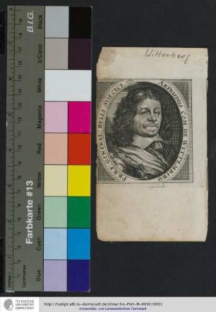
Arfriedus Com: De Wittemberg Præf: General: Belli Suecici
Mappa Geographica Circuli Metalliferi Electoratus Saxoniæ cum omnibus, quæ in eo comprehenduntur Præfecturis Et Dynastiis : quales sunt I. Præf. Zwickavienses, II. Præf. Schwarzenbergens. III. Dyn. Hartenstein, IV. Glaucha, V. Præf. Lemsa, VI. Præf. Waldenburg, VII Præf. Rochsburg, VIII. Præf. Penig, IX. Præf. Wechselburg, X. Præf. Chemnit, XI Præf. Stollberg, XII. Præf. Grunhayn, XIII. Præf. Wolckenstain, XIV. Præf. Lauterstein, XV. Præf. Augustopolit. XVI. Præf. Franckenberg, XVII. Præf. Nossen, XVIII. Præf. Freyberg, XIX. Præf. Grullenburg, XX Præf. Frauenstein, XXI Præf. Altenberg, XXII Præf. Dippoldiswalda, Accedunt præfecturæ circuli Misnici XXIII. Præf. Pirnensis cum Dyn. Lauenstein, XXIV. Præf. Loehmen, XXV. Præf. Hohenstein
Karte vom Erzgebirgischen Kreis, 1:170 000, Kupferstich, nach 1739 : Mappa Geographica Circuli Metalliferi Electoratus Saxoniae cum omnibus, quae in eo comprehenduntur Praefecturis Et Dynastiis : quales sunt I. Praef. Zwickavienses, II. Praef. Schwarzenbergens. III. Dyn. Hartenstein, IV. Glaucha, V. Praef. Lemsa, VI. Praef. Waldenburg, VII Praef. Rochsburg, VIII. Praef. Penig, IX. Praef. Wechselburg, X. Praef. Chemnit, XI Praef. Stollberg, XII Praef. Grunhayn, XIII. Praef. Wolckenstain, XIV. Praef. Lauterstein, XV. Praef. Augustopolit. XVI. Praef. Franckenberg, XVII Praef. Nossen, XVIII Praef. Freyberg, XIX. Praef. Grullenburg, XX Praef. Frauenstein, XXI Praef. Altenberg, XXII Praef. Dippoldiswalda, Accedunt praefecturae circuli Misnici XXIII. Praef. Pirnensis cum Dyn. Lauenstein, XXIV. Praef. Loehmen, XXV. Praef. Hohenstein ; Cum Priv. S. M. Polon. et Elect. Saxon. / cura Matth. Seutter, Geogr. Caesar. Aug. Vind. Tob. Conr. Lotter sculpsit. - [Ca. 1:170 000]. - Aug. Vind. , [nach 1739]. - 1 Kt. auf 2 Bl. : Kupferst. ; Gesamtgr. 96 x 56 cm, je Teil 48 x 56 cm
[Præf. Ad Lectores.]
Præf. Ad Valer. Mag.
Steph. in Praef. ad Bell. aquat.
25. 26 Bellum Geticum c. praef.
30. 31 Epithalamium Palladii c. praef.
27. 28 Sextus Consulatus Honorii c. praef.
L. XXX. Idem A. Joanni Praef. Praet.
L. X. Imp. Justinianus A. Mennae Praef. Praet.
L. XI. & Ult. Idem A. Joanni Praef. Praet.