Luftbildpläne
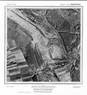
Haverlahwiese, Gauß-Krüger-Koordinaten: Rechtswert: 3590, Hochwert: 5774
- Dimensions
-
Maßstab: 1:10.000
- Further information
-
Land: Niedersachsen
- Context
-
Hansa Luftbild: Luftbildpläne 1:10.000 >> 6. Rechtswerte beginnend mit 35
- Holding
-
RW 0434 Hansa Luftbild: Luftbildpläne 1:10.000
- Creator
-
Hersteller: Hansa Luftbild
- Provenance
-
Hansa Luftbild
- Date of creation
-
1958
- Other object pages
- Delivered via
- Last update
-
24.06.2025, 2:16 PM CEST
Data provider
This object is provided by:
Landesarchiv Nordrhein-Westfalen. Abteilung Rheinland. If you have any questions about the object, please contact the data provider.
Landesarchiv Nordrhein-Westfalen. Abteilung Rheinland. If you have any questions about the object, please contact the data provider.
Object type
- Luftbildpläne
Associated
- Hersteller: Hansa Luftbild
- Hansa Luftbild
Time of origin
- 1958
Other Objects (12)
Haverlahwiese, Gauß-Krüger-Koordinaten: Rechtswert: 3590, Hochwert: 5774
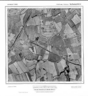
Rethwischfeld, Gauß-Krüger-Koordinaten: Rechtswert: 3590, Hochwert: 5962

Lebenstedt, Gauß-Krüger-Koordinaten: Rechtswert: 3590, Hochwert: 5780
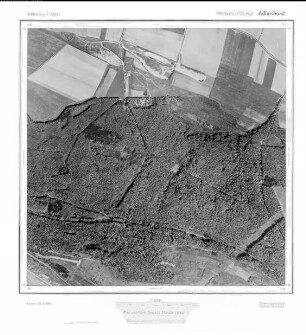
Adlershorst, Gauß-Krüger-Koordinaten: Rechtswert: 3590, Hochwert: 5776
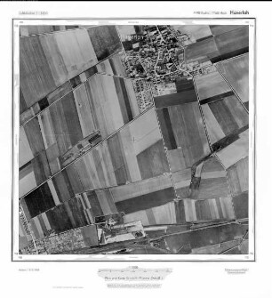
Haverlah, Gauß-Krüger-Koordinaten: Rechtswert: 3590, Hochwert: 5768
Lichtenberg, Gauß-Krüger-Koordinaten: Rechtswert: 3590, Hochwert: 5776
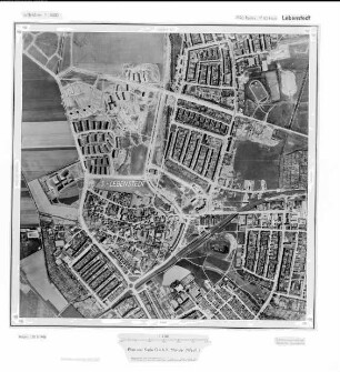
Lebenstedt, Gauß-Krüger-Koordinaten: Rechtswert: 3590, Hochwert: 5780
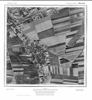
Broistedt, Gauß-Krüger-Koordinaten: Rechtswert: 3590, Hochwert: 5784
Lichtenberg, Gauß-Krüger-Koordinaten: Rechtswert: 3590, Hochwert: 5778
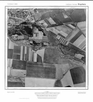
Ringelheim, Gauß-Krüger-Koordinaten: Rechtswert: 3590, Hochwert: 5766
Lebenstedt, Gauß-Krüger-Koordinaten: Rechtswert: 3590, Hochwert: 5782
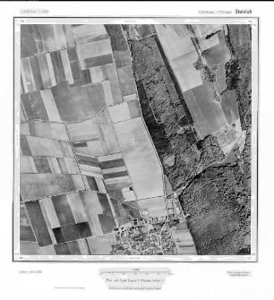
Steinlah, Gauß-Krüger-Koordinaten: Rechtswert: 3590, Hochwert: 5772
Haverlahwiese, Gauß-Krüger-Koordinaten: Rechtswert: 3590, Hochwert: 5774
Rethwischfeld, Gauß-Krüger-Koordinaten: Rechtswert: 3590, Hochwert: 5962
Lebenstedt, Gauß-Krüger-Koordinaten: Rechtswert: 3590, Hochwert: 5780
Adlershorst, Gauß-Krüger-Koordinaten: Rechtswert: 3590, Hochwert: 5776
Haverlah, Gauß-Krüger-Koordinaten: Rechtswert: 3590, Hochwert: 5768
Lichtenberg, Gauß-Krüger-Koordinaten: Rechtswert: 3590, Hochwert: 5776
Lebenstedt, Gauß-Krüger-Koordinaten: Rechtswert: 3590, Hochwert: 5780
Broistedt, Gauß-Krüger-Koordinaten: Rechtswert: 3590, Hochwert: 5784
Lichtenberg, Gauß-Krüger-Koordinaten: Rechtswert: 3590, Hochwert: 5778
Ringelheim, Gauß-Krüger-Koordinaten: Rechtswert: 3590, Hochwert: 5766
Lebenstedt, Gauß-Krüger-Koordinaten: Rechtswert: 3590, Hochwert: 5782