Karte / Plan
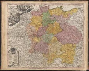
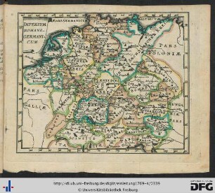
Imperium Romano-Germanicum in suos Circulos Divisum Geographice exhibitum et in Usum Scholarum ad mentem Ioh. Hübneri Collegii Iohannei Hamburgi Rectoris Excellentissimi destinatum;. Bildfläche: Nordseeküste Calais bis Elbmündung – Danzig – Lyon – Rator (Kroatien);. Inhalt: Jülich
- Reference number
-
A - Landkarten, A 24
- Former reference number
-
GS 26 (aufgeklebt u. handschr.)
- Dimensions
-
Blatt: 505 x 600 mm; Karte: 480 x 563 mm
- Formal description
-
rechts oben Titel mit Putten und einer Königsfigur sowie Portrait von Johann Hübner (?) mit dem Schriftzug „Constantia et Fortitudine“. Unten links Kartusche mit Bezeichnung der einzelnen Territorien.
- Notes
-
Rückseitig mit Bleistift: „2690/19“ u. „Deutschland (Gesamtgebiet)“ Ankauf 1951
- Further information
-
Ort: Nürnberg (Norimberg)
Ausführung: mehrfarbig (altkoloriert)
Maßstab: ca. 1 : 2 187 000
Druck / Verlag: Johann Baptist Homann SCM Geographo et Regiae Boruss. Societatis Scientiarum Membro
- Context
-
Landkarten
- Holding
-
A - Landkarten Landkarten
- Indexentry person
- Date of creation
-
[1729]
- Other object pages
- Provenance
-
Antiquariat Adolf Ludwig, Mannheim, Windeckstr. 33
- Delivered via
- Last update
-
05.11.2025, 3:42 PM CET
Data provider
This object is provided by:
Stadtarchiv Jülich. If you have any questions about the object, please contact the data provider.
Stadtarchiv Jülich. If you have any questions about the object, please contact the data provider.
Object type
- Karten und Pläne
Time of origin
- [1729]
Other Objects (12)
!["Imperium Romano-Germanicum in suos circulos divisum geographice exhibitum et in usum scholarum ad mentem Joh[annis] Hübneri, Collegii Johannei Hamburgi Rectoris, excellentissimi destinatum [...]"](/assets/placeholder/searchResultMediaNoDigitisedMedia.png)
"Imperium Romano-Germanicum in suos circulos divisum geographice exhibitum et in usum scholarum ad mentem Joh[annis] Hübneri, Collegii Johannei Hamburgi Rectoris, excellentissimi destinatum [...]"
Imperium Romano-Germanicum In Suos Circulos Divisum : Cum Privilegio Sac. Cæs. Majest.
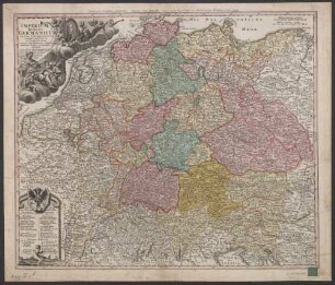
Imperium Romano-germanicum In Suos Circulos Divisum : Cum Privilegio Sac. Caes. Maiest.
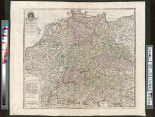
Imperium Romano-Germanicum in suos Circulos Electoratus Et Status Summa cura et Studio divisum
![Imperium Romano-Germanicum in suos Circulos Electorat[us] Et Status Summâ curâ et Studio divisum](https://iiif.deutsche-digitale-bibliothek.de/image/2/291c97e1-1827-4366-936f-58c89ce73a44/full/!306,450/0/default.jpg)
Imperium Romano-Germanicum in suos Circulos Electorat[us] Et Status Summâ curâ et Studio divisum
Elbmündung
Círculos
Die Elbmündung

Cuxhafen: Elbmündung

Cuxhafen: Elbmündung

Cuxhafen: Elbmündung
Imperium Romano-Germanicum.
"Imperium Romano-Germanicum in suos circulos divisum geographice exhibitum et in usum scholarum ad mentem Joh[annis] Hübneri, Collegii Johannei Hamburgi Rectoris, excellentissimi destinatum [...]"
Imperium Romano-Germanicum In Suos Circulos Divisum : Cum Privilegio Sac. Cæs. Majest.
Imperium Romano-germanicum In Suos Circulos Divisum : Cum Privilegio Sac. Caes. Maiest.
Imperium Romano-Germanicum in suos Circulos Electoratus Et Status Summa cura et Studio divisum
Imperium Romano-Germanicum in suos Circulos Electorat[us] Et Status Summâ curâ et Studio divisum
Elbmündung
Círculos
Die Elbmündung
Cuxhafen: Elbmündung
Cuxhafen: Elbmündung
Cuxhafen: Elbmündung