- Alternativer Titel
-
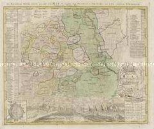
LANDGRAVIAT / THURINGIA / TABULA GENERALIS / in suos / PRINCIPATUS ET STATUS / accurate divisa / per / JOH. BAPT. HOMANN / Norimbergae
- Standort
-
Deutsches Historisches Museum, Berlin
- Inventarnummer
-
Do 2003/17
- Maße
-
Höhe x Breite: 48 x 57 cm (Karte)
Höhe x Breite: 52 x 62,8 cm (Blatt)
- Material/Technik
-
Karte: Druckfarbe, Papier, Kupferstich, koloriert
- Klassifikation
-
Kartografie (Gattung)
- Bezug (was)
-
Thüringen
- Ereignis
-
Herstellung
- (wer)
-
Geograph, Kartograf, Verleger: Johann Baptist Homann
Verleger: Johann Christoph Homann
Geograph: Friedrich Christian Lesser
Verlag: Homannsche Erben
- (wo)
-
Nürnberg [historisch: Norimbergae], Deutschland [historisch: Heiliges Römisches Reich]
- (wann)
-
1738
- Rechteinformation
-
Deutsches Historisches Museum
- Letzte Aktualisierung
-
24.03.2023, 09:28 MEZ
Datenpartner
Dieses Objekt wird bereitgestellt von:
Stiftung Deutsches Historisches Museum. Bei Fragen zum Objekt wenden Sie sich bitte an den Datenpartner.
Stiftung Deutsches Historisches Museum. Bei Fragen zum Objekt wenden Sie sich bitte an den Datenpartner.
Objekttyp
- Regionalkarte
Beteiligte
- Geograph, Kartograf, Verleger: Johann Baptist Homann
- Verleger: Johann Christoph Homann
- Geograph: Friedrich Christian Lesser
- Verlag: Homannsche Erben
Entstanden
- 1738
Ähnliche Objekte (12)
Tractus Nordlingensis Germ. RIES dicti accurata Descriptio. Mit einer Ansicht und einem Grundriss von Nördlingen

Tabula Geographica Totam Borussiam ut et Districtum Notecensem. Mit einer Nebenkarte: Charte welche den Netz District vorstellet
Pläne der kanadischen Städte Louisburg, Québec und Halifax unter französischer und englischer Herrschaft
Tabula Geographica Campaniae. Mit zwei Nebenkarten: Reims und Troyes

Repraesentatio Geographica Circuli Egerani
La Comtè de Glatz
Comitauts Hohnstein
Circuli Supe. Saxoniae
Lusatiae Inferioris
Superiorem Silesiam
Geographische Verzeichnung des Budissinischen Creises
Circuli Supe. Saxoniae
Tractus Nordlingensis Germ. RIES dicti accurata Descriptio. Mit einer Ansicht und einem Grundriss von Nördlingen
Tabula Geographica Totam Borussiam ut et Districtum Notecensem. Mit einer Nebenkarte: Charte welche den Netz District vorstellet
Pläne der kanadischen Städte Louisburg, Québec und Halifax unter französischer und englischer Herrschaft
Tabula Geographica Campaniae. Mit zwei Nebenkarten: Reims und Troyes
Repraesentatio Geographica Circuli Egerani
La Comtè de Glatz
Comitauts Hohnstein
Circuli Supe. Saxoniae
Lusatiae Inferioris
Superiorem Silesiam
Geographische Verzeichnung des Budissinischen Creises