Verzeichnung
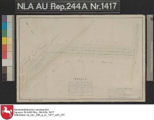
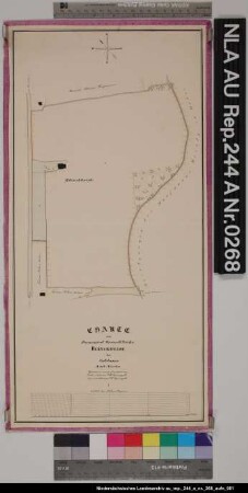
Nivellementsplan des Brandschlottes und der Ehe von Sandhorst bis hinter PLAGGENBURG Kolorierte Zeichnung von F. W. Sprengell Papier auf Leinen Format 70,6x38,0 M 1:100/1:10.000
- Reference number
-
NLA HA, Rep. 244, B Nr. 1750
- Former reference number
-
Rep. 244, 4960 B
Rep. 244 B 4960
- Further information
-
Ergänzungen: Klassifikation TeilB: Plaggenburg
- Context
-
Kartensammlung >> 5 Regierungsbezirk Weser-Ems >> 3 Kreis Aurich >> 10 Gewässer, Kanäle, Seekarten
- Holding
-
Rep. 244 Kartensammlung
- Indexbegriff subject
-
Brandschlott Sandhorst/Plaggenburg
- Indexentry person
-
Sprengell, F. W.
- Indexentry place
-
Ehe, Sandhorst/Plaggenburg
Plaggenburg/Sandhorst, Brandschlott
Plaggenburg/Sandhorst, Ehe
Sandhorst/Plaggenburg, Brandschlott
Sandhorst/Plaggenburg, Ehe
- Date of creation
-
- 1871
- Other object pages
- Last update
-
16.06.2025, 1:30 PM CEST
Data provider
This object is provided by:
Niedersächsisches Landesarchiv. If you have any questions about the object, please contact the data provider.
Niedersächsisches Landesarchiv. If you have any questions about the object, please contact the data provider.
Object type
- Verzeichnung
Time of origin
- - 1871
Other Objects (12)

Lage der Gemarkung PLAGGENBURG Kolorierte Zeichnung von F. W. Sprengell Papier auf Leinen Format 100,0x66,0 M 1:3.750
Die Kolonatsregulierung im Moor von PLAGGENBURG und Dietrichsfeld Kolorierte Zeichnung von F. W. Sprengell Papier auf Leinen Format 69,0x73,0 M 1:4.000
Lage eines Kolonats von G. J. Frerichs in PLAGGENBURG am Weg nach Dietrichsfeld Kolorierte Zeichnung von F. W. Sprengell Papier auf Leinen Format 40,0x26,8 M 1:2.000
Profil des Brandschlottes zwischen dem fiskalischen Moor und den neuen Grundausweisungen in PLAGGENBURG Kolorierte Zeichnung von F. W. Sprengell Papier auf Leinen Format 44,5x24,0 M 1:100/1:6.000
Nivellementsplan des Ems-Jade-Kanals von Upschört bis Aurich Kolorierte Zeichnung von F. W. Sprengell Pappe Format 246,0x46,3 M 1:3.000 (ca)
Nivellementsplan des Ems-Jade-Kanals von Upschört nach Aurich Kolorierte Zeichnung von F. W. Sprengell Papier auf Leinen Format 252,3x44,5 M 1:9.200 (ca)
Vergrößerungsflächen für GROSSEFEHN und Spetzerfehn Zeichnung von F. W. Sprengell Papier Format 41,5x33,0 M 1:1.000 (ca)
Plan der Gemarkung SPEKENDORF Kolorierte Zeichnung von F. W. Sprengell Papier auf Leinen Format 73,2x50,2 M 1:2.000
Übersicht der Gemarkung KOLLRUNGE Kolorierte Zeichnung von F. W. Sprengell Papier auf Leinen Format 32,5x32,0 M 1:15.000
Lage der Ortschaft DIETRICHSFELD Kolorierte Zeichnung von F. W. Sprengell Papier auf Leinen Format 128,0x97,6 M 1:3.200
Lage des Domanialgrundstückes BLINKHEIDE bei Coldinne Kolorierte Zeichnung von F. W. Sprengell Papier Format 24,0x50,0 M 1:2.000
Das Kolonatsregulierungsprojekt in WIESEDERFEHN Kolorierte Zeichnung von F. W. Sprengell Papier auf Leinen Format 92,7x62,3 M 1:2.000
Lage der Gemarkung PLAGGENBURG Kolorierte Zeichnung von F. W. Sprengell Papier auf Leinen Format 100,0x66,0 M 1:3.750
Die Kolonatsregulierung im Moor von PLAGGENBURG und Dietrichsfeld Kolorierte Zeichnung von F. W. Sprengell Papier auf Leinen Format 69,0x73,0 M 1:4.000
Lage eines Kolonats von G. J. Frerichs in PLAGGENBURG am Weg nach Dietrichsfeld Kolorierte Zeichnung von F. W. Sprengell Papier auf Leinen Format 40,0x26,8 M 1:2.000
Profil des Brandschlottes zwischen dem fiskalischen Moor und den neuen Grundausweisungen in PLAGGENBURG Kolorierte Zeichnung von F. W. Sprengell Papier auf Leinen Format 44,5x24,0 M 1:100/1:6.000
Nivellementsplan des Ems-Jade-Kanals von Upschört bis Aurich Kolorierte Zeichnung von F. W. Sprengell Pappe Format 246,0x46,3 M 1:3.000 (ca)
Nivellementsplan des Ems-Jade-Kanals von Upschört nach Aurich Kolorierte Zeichnung von F. W. Sprengell Papier auf Leinen Format 252,3x44,5 M 1:9.200 (ca)
Vergrößerungsflächen für GROSSEFEHN und Spetzerfehn Zeichnung von F. W. Sprengell Papier Format 41,5x33,0 M 1:1.000 (ca)
Plan der Gemarkung SPEKENDORF Kolorierte Zeichnung von F. W. Sprengell Papier auf Leinen Format 73,2x50,2 M 1:2.000
Übersicht der Gemarkung KOLLRUNGE Kolorierte Zeichnung von F. W. Sprengell Papier auf Leinen Format 32,5x32,0 M 1:15.000
Lage der Ortschaft DIETRICHSFELD Kolorierte Zeichnung von F. W. Sprengell Papier auf Leinen Format 128,0x97,6 M 1:3.200
Lage des Domanialgrundstückes BLINKHEIDE bei Coldinne Kolorierte Zeichnung von F. W. Sprengell Papier Format 24,0x50,0 M 1:2.000