Karte
THE NORTH EASTERN PART of the TERRITORY OF NEW SOUTH WALES between PORT MACQUARIE and MORETON BAY 1843

- Umfang
-
1 page
- Sprache
-
Englisch
- Erschienen in
-
Australia from Port Macquarie to Moreton Bay; with descriptions of the natives, their manners and customs; the geology, natural productions, fertility, and resources of that region; first explored and surveyed
- Erschienen
-
1845
- Letzte Aktualisierung
-
26.05.2025, 15:46 MESZ
Datenpartner
Dieses Objekt wird bereitgestellt von:
Niedersächsische Staats- und Universitätsbibliothek Göttingen. Bei Fragen zum Objekt wenden Sie sich bitte an den Datenpartner.
Niedersächsische Staats- und Universitätsbibliothek Göttingen. Bei Fragen zum Objekt wenden Sie sich bitte an den Datenpartner.
Objekttyp
- Karte
Entstanden
- 1845
Ähnliche Objekte (12)
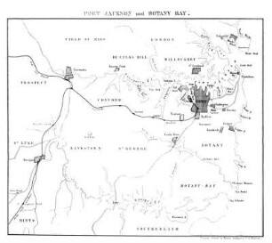
Port Jackson und Botany Bay

Verfahren Gertrud Prochownik, 28 Eastern Ave., Rose Bay North, New South Wales, Australien, gegen das Deutsche Reich
Verfahren Gertrud Prochownik, 28 Eastern Ave., Rose Bay North, New South Wales, Australien, gegen das Deutsche Reich
Verfahren Gertrud Prochownik, 28 Eastern Ave., Rose Bay North, New South Wales, Australien, gegen das Deutsche Reich
Verfahren Gertrud Prochownik, 28 Eastern Ave., Rose Bay North, New South Wales, Australien, gegen das Deutsche Reich
Verfahren Gertrud Prochownik, 28 Eastern Ave., Rose Bay North, New South Wales, Australien, gegen das Deutsche Reich
Verfahren Gertrud Prochownik, 28 Eastern Ave., Rose Bay North, New South Wales, Australien, gegen das Deutsche Reich
Verfahren Gertrud Prochownik, 28 Eastern Ave., Rose Bay North, New South Wales, Australien, gegen das Deutsche Reich
territory
Verfahren Nora Caspari, Double Bay, New South Wales, Australien
Verfahren Nora Caspari, Double Bay, New South Wales, Australien
Verfahren Nora Caspari, Double Bay, New South Wales, Australien
Port Jackson und Botany Bay
Verfahren Gertrud Prochownik, 28 Eastern Ave., Rose Bay North, New South Wales, Australien, gegen das Deutsche Reich
Verfahren Gertrud Prochownik, 28 Eastern Ave., Rose Bay North, New South Wales, Australien, gegen das Deutsche Reich
Verfahren Gertrud Prochownik, 28 Eastern Ave., Rose Bay North, New South Wales, Australien, gegen das Deutsche Reich
Verfahren Gertrud Prochownik, 28 Eastern Ave., Rose Bay North, New South Wales, Australien, gegen das Deutsche Reich
Verfahren Gertrud Prochownik, 28 Eastern Ave., Rose Bay North, New South Wales, Australien, gegen das Deutsche Reich
Verfahren Gertrud Prochownik, 28 Eastern Ave., Rose Bay North, New South Wales, Australien, gegen das Deutsche Reich
Verfahren Gertrud Prochownik, 28 Eastern Ave., Rose Bay North, New South Wales, Australien, gegen das Deutsche Reich
territory
Verfahren Nora Caspari, Double Bay, New South Wales, Australien
Verfahren Nora Caspari, Double Bay, New South Wales, Australien