Karten und Pläne
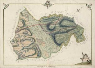
Topographischer Plan von Maulburg und Hoellstein
Wie H Maulburg 1, ohne Verzierungen, hellere Farben.
- Reference number
-
Abt. Generallandesarchiv Karlsruhe, H Maulburg 4
- Dimensions
-
52,3 x 73 (Höhe x Breite)
- Further information
-
Orientierung: NW
Originalmaßstab: 300 Ruten, 10 = 0,4 cm
- Context
-
Gemarkungspläne >> Erste badische Landesaufnahme >> Obere Markgrafschaft (Sausenberg, Rötteln, Badenweiler) >> Landgrafschaft Sausenberg / Herrschaft Rötteln / Oberamt Lörrach >> Ortsgemarkungen >> Serie D (Ludwig u.a.)
- Holding
-
Landesarchiv Baden-Württemberg, Abt. Generallandesarchiv Karlsruhe, H Gemarkungspläne
- Indexentry place
-
Höllstein : Steinen LÖ; Bad. Landesaufnahme (1784)
Maulburg LÖ; Bad. Landesaufnahme (1784)
- Creator
-
Autor/Fotograf: C. W. Ludwig
- Date of creation
-
1784
- Other object pages
- View digital item at providers-website
- Rights
-
Es gelten die Nutzungsbedingungen des Landesarchivs Baden-Württemberg.
- Last update
-
04.04.2025, 8:07 AM CEST
Data provider
This object is provided by:
Landesarchiv Baden-Württemberg. If you have any questions about the object, please contact the data provider.
Landesarchiv Baden-Württemberg. If you have any questions about the object, please contact the data provider.
Object type
- Karten und Pläne
Associated
- Autor/Fotograf: C. W. Ludwig
Time of origin
- 1784
Other Objects (12)
Topographischer Plan von Maulburg und Höllsteiner Bann

Zentrumsverein Höllstein-Steinen-Maulburg
Grundriss über die zwischen Maulburg, Hüsingen et Höllstein obwaltenden Bann- und Zehend-Streittsache
Arbeiterkonsumverein Steinen, Höllstein und Maulburg
Verlegung der Gemarkungsgrenze zwischen Maulburg - Höllstein - Hüfingen

Maulburg (LÖ)
Höllstein (Steinen LÖ)
Flurkarte Gemarkung Höllstein
Flurkarte Gemarkung Höllstein
Flurkarte Gemarkung Höllstein
Flurkarte Gemarkung Höllstein
Erneuerung von Gülten zu Maulburg, Höllstein und Hüsingen.
Topographischer Plan von Maulburg und Höllsteiner Bann
Zentrumsverein Höllstein-Steinen-Maulburg
Grundriss über die zwischen Maulburg, Hüsingen et Höllstein obwaltenden Bann- und Zehend-Streittsache
Arbeiterkonsumverein Steinen, Höllstein und Maulburg
Verlegung der Gemarkungsgrenze zwischen Maulburg - Höllstein - Hüfingen
Maulburg (LÖ)
Höllstein (Steinen LÖ)
Flurkarte Gemarkung Höllstein
Flurkarte Gemarkung Höllstein
Flurkarte Gemarkung Höllstein
Flurkarte Gemarkung Höllstein